
National Register of Historic Places listings in Marion County, South Carolina facts for kids

Have you ever wondered about the oldest buildings or special places in your town? In Marion County, South Carolina, there are many important spots that tell stories about the past. These places are so special that they are listed on something called the National Register of Historic Places.
This list helps us keep track of buildings, areas, and objects that are important to the history of the United States. It's like a special club for historic sites! In Marion County, there are 13 places on this list, and two of them are even more important, called National Historic Landmarks. Some places were once on the list but have since been removed, often because they were changed or no longer exist.
Contents
Discover Marion County's Historic Gems
The National Register of Historic Places helps protect and celebrate buildings and areas that have a lot of history. When a place is listed, it means it's recognized for its special importance. Let's explore some of these cool spots in Marion County!
Buildings with a Past
Many of the places on the list are old buildings that once served important purposes in their communities.
- A.H. Buchan Company Building in Mullins: This building was listed in 1984. It's a reminder of the businesses that helped Mullins grow.
- Dew Barn near Zion: Listed in 1984, this barn shows us what farming life was like long ago in Marion County.
- Dillard Barn in Mullins: Added to the list in 2005, this barn is another example of the area's agricultural history.
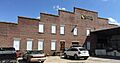
- Imperial Tobacco Company Building in Mullins: Also listed in 1984, this building was part of the big tobacco industry that was important to Mullins.
- Liberty Warehouse in Mullins: This warehouse, listed in 1984, was likely used for storing goods, possibly tobacco, showing the town's busy past.
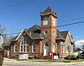
- Mt. Olive Baptist Church in Mullins: This church, listed in 2000, is an important part of the community's history and spiritual life.
- Neal and Dixon's Warehouse in Mullins: Listed in 1984, this is another historic warehouse from Mullins.
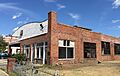
- Rasor and Clardy Company Building in Mullins: This building, listed in 1982, also tells a story about the businesses that shaped Mullins.
Schools and Districts with History
Some places on the list are entire areas or important community buildings like schools.
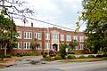
- Marion High School in Marion: This building, listed in 2001, was once a high school. Now, it's the main office for the Marion County School District, still serving the community!
- Marion Historic District in Marion: This isn't just one building; it's a whole area! Listed in 1973, this district includes many historic homes and buildings that show what Marion looked like long ago. It even had its boundaries expanded in 1979 to include more historic spots.
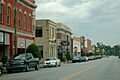
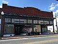
- Mullins Commercial Historic District in Mullins: Similar to Marion's district, this area in Mullins, listed in 2003, includes many old shops and businesses along streets like Main, Front, and West Wine. It gives us a peek into the town's busy commercial past.
Churches and Other Landmarks
- Old Ebenezer Church near Latta: This church, listed in 1973, is located a few miles south of Latta. It's a historic place of worship that has stood for many years.
Places No Longer on the List
Sometimes, a historic place might be removed from the National Register. This can happen if the building is changed too much, or if it's unfortunately torn down.
- Old Brick Warehouse in Mullins: This warehouse was listed in 1984 but was removed from the list in 2016 because it was demolished.
- J.C. Teasley House in Mullins: This house was listed in 2001 but was also removed in 2016 because it was demolished in 2015.
These former listings remind us that it's important to protect our historic places so future generations can learn from them.
Images for kids
-
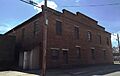
A.H. Buchan Company Building
-
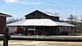
Dillard Barn
-
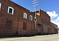
Imperial Tobacco Company Building
-
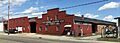
Liberty Warehouse
-
Marion High School
-
Marion Historic District
-
Mt. Olive Baptist Church
-
A building in the Mullins Commercial Historic District
-
Neal and Dixon's Warehouse
-
Rasor and Clardy Company Building
-
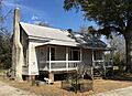
J.C. Teasley House (now demolished)


