
National Register of Historic Places listings in Marion County, West Virginia facts for kids

Have you ever wondered about the old buildings and special places in your town? In Marion County, West Virginia, there's a list of amazing spots that are super important to history! This list is called the National Register of Historic Places. It's like a special club for buildings, bridges, and areas that tell a big story about the past. When a place is on this list, it means it's recognized as a valuable part of American history and culture.
In Marion County, there are 22 different places and areas that have earned a spot on this important list. These sites include everything from old schools and grand houses to unique bridges and entire historic neighborhoods. They help us remember how people lived, worked, and built communities long ago in West Virginia. Let's explore some of these cool historic treasures!
Contents
- Historic Treasures of Marion County
- Barrackville Covered Bridge
- Dunbar School: A Place for Learning
- Fairmont Downtown Historic District
- Fairmont Senior High School
- Hamilton Round Barn: A Unique Farm Building
- High Gate: A Grand Home
- High Level Bridge: Crossing the Monongahela River
- Marion County Courthouse
- Prickett's Fort: A Frontier Story
- Other Notable Places
- Images for kids
Historic Treasures of Marion County
Barrackville Covered Bridge
Imagine crossing a bridge that's completely covered, like a tunnel! The Barrackville Covered Bridge is one of these rare and beautiful structures. It was built way back in 1853 and crosses Buffalo Creek near Barrackville, West Virginia. Covered bridges were popular because the roof and sides protected the wooden parts from rain and snow, making them last much longer. This bridge is a fantastic example of old-time engineering and a real piece of history you can still see today.

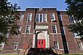
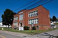
Dunbar School: A Place for Learning
The Dunbar School in Fairmont, West Virginia, is more than just an old building; it's a symbol of education and community. Built in 1928, this school played a big role in the lives of many students. It's a great example of the school buildings from that time period and reminds us how important schools have always been for young people.
.jpg)
Fairmont Downtown Historic District
Sometimes, it's not just one building that's historic, but a whole group of them! The Fairmont Downtown Historic District includes many old buildings along streets like Jackson, Adams, and Washington. This area shows what a busy and important downtown looked like in the past. Walking through it is like taking a step back in time, seeing the architecture and layout of a historic city center.

Fairmont Senior High School
Even schools can be historic! The Fairmont Senior High School building, located at 1 Loop Park, was added to the National Register in 2002. It's a significant landmark in Fairmont, West Virginia, and has been a place of learning for generations of students. It shows how important education has been to the community for a long time.

Hamilton Round Barn: A Unique Farm Building
Have you ever seen a round barn? The Hamilton Round Barn near Mannington, West Virginia, is a very unusual and cool building! Built in 1911, it's one of only a few round barns left in West Virginia. Farmers sometimes built round barns because they believed they were more efficient for feeding livestock and storing hay. It's a fun example of different ways people used to build things on farms.

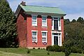
High Gate: A Grand Home
High Gate is a beautiful and impressive house located at 801 Fairmont Avenue in Fairmont, West Virginia. This grand home was built in 1910 and is known for its stunning architecture. It gives us a peek into how some of the more prominent families lived in the early 20th century.

High Level Bridge: Crossing the Monongahela River
Bridges are super important for connecting places, and the High Level Bridge (also known as the Robert H. Mollohan-Jefferson Street Bridge) is a major one in Fairmont. It crosses the Monongahela River and was built in 1921. This bridge is an amazing example of engineering from its time, allowing people and goods to move easily across the river.

Marion County Courthouse
The Marion County Courthouse and Sheriff's House are important buildings in Fairmont, West Virginia. Located at Adams and Jefferson Streets, the courthouse is where many important decisions for the county are made. These buildings represent the legal and governmental history of Marion County.

Prickett's Fort: A Frontier Story
Prickett's Fort is a really exciting historic site! It's a reconstructed fort that shows what life was like on the frontier in the late 1700s. Located in Prickett's Fort State Park near Fairmont, West Virginia, the fort helps us understand the challenges and daily lives of early settlers in West Virginia. It's a great place to learn about pioneer history.

Other Notable Places
Marion County is full of other amazing historic spots too!
- The Colonial Apartments in Fairmont, built in 1923, show us what apartment living was like almost a century ago.
- The Fairmont Normal School Administration Building is part of the history of higher education in the area.
- The Thomas W. Fleming House and the Fleming-Watson Historic District are examples of beautiful residential areas from the past.
- The Jacobs-Hutchinson Block is a historic commercial building in downtown Fairmont.
- The Mannington Historic District is another area with many important old buildings, similar to the one in Fairmont.
- The Masonic Temple in Fairmont is a grand building with unique architecture.
- The Thomas C. Miller Public School is another historic school building that served the community.
- The George Pinkney Morgan House near Rivesville, West Virginia, is a historic home with a story to tell.
- The Jacob Prickett, Jr. Log House is an even older, simpler home that shows how early settlers lived.
- The Shaw House in Fairmont is another significant historic residence.
- The Wilson School in Mannington, West Virginia, adds to the list of important educational buildings.
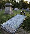
- And finally, Woodlawn Cemetery in Fairmont is a historic cemetery where many important figures from the county's past are laid to rest.
These places are more than just old buildings; they are windows into the past, helping us understand the rich history and development of Marion County, West Virginia.
Images for kids
-
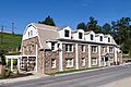
Colonial Apartments
-
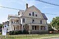
A building in the Fleming-Watson Historic District.
-
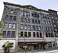
The Jacobs-Hutchinson Block.
-
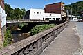
Buildings in the Mannington Historic District.
-

The Masonic Temple in Fairmont.
-
Thomas C. Miller Public School.
-
The George Pinkney Morgan House.
-
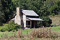
The Jacob Prickett, Jr. Log House.
-
The Shaw House.
-
Wilson School in Mannington.
-
Woodlawn Cemetery.


