
National Register of Historic Places listings in Monroe County, Missouri facts for kids

Monroe County, Missouri, is home to many special places that are listed on the National Register of Historic Places. This register is like a special list kept by the United States government. It helps protect buildings, sites, and objects that are important to history. When something is on this list, it means it has a unique story to tell about the past.
These places could be old houses, ancient sites, or even parts of parks. They show us how people lived, worked, and played many years ago. In Monroe County, there are 10 different spots that have earned a place on this important list. Let's explore some of them and learn about their cool history!
Contents
Exploring Monroe County's Historic Treasures
Monroe County has a rich history, and many of its important sites are preserved for everyone to learn from. These places help us understand what life was like long ago.
Mark Twain's Special Places
Monroe County is famous for being the birthplace of Samuel Clemens, better known as the author Mark Twain. He wrote classic books like The Adventures of Tom Sawyer and Adventures of Huckleberry Finn. Two places connected to him are on the historic register.
Mark Twain Birthplace Cabin

The Mark Twain Birthplace State Historic Site is where you can see the small cabin where Samuel Clemens was born in 1835. It's located near the town of Florida. This simple cabin shows us how families lived in Missouri almost 200 years ago. It's amazing to think that one of America's most famous writers started his life in such a humble place. The cabin was added to the National Register on May 21, 1969.
Mark Twain State Park Picnic Shelter
Also in Mark Twain State Park, near Santa Fe, is the Picnic Shelter at Buzzard's Roost. This shelter was built a long time ago and is a great example of how parks were designed for visitors. It's a nice spot to relax and enjoy nature, just like people have done for many years. It became a historic site on March 4, 1985.
Ancient History and Art
Monroe County also holds secrets from even older times, showing us how people lived thousands of years ago.
Crigler Mound Group Archeological Site
The Crigler Mound Group is an ancient site located north of Florida. It contains mounds that were built by Native American people long, long ago. Archeologists study these mounds to learn about the cultures and lives of the first people who lived in this area. It's a fascinating look into prehistoric times. This site was recognized on May 21, 1969.
Holliday Petroglyphs
The Holliday Petroglyphs are another incredible ancient discovery. These are carvings made into rocks by early Native Americans. They are found northeast of Holliday. Petroglyphs are like ancient drawings or messages, giving us clues about the beliefs and daily lives of people who lived here centuries ago. They were added to the register on January 11, 1974.
Historic Buildings and Structures
Many buildings in Monroe County tell stories about the communities that grew there.
Farmers and Merchants Bank Building

In Monroe City, the Farmers and Merchants Bank Building stands as a reminder of the town's past. Located at 201-207 S. Main Street, this building shows the style of architecture that was popular when it was built. Banks were very important centers for communities, helping businesses and families. It joined the list on January 12, 2012.
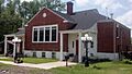
St. Jude's Episcopal Church

Also in Monroe City, at 301 N. Main Street, is St. Jude's Episcopal Church. This beautiful church has been a place of worship and community gathering for many years. Its architecture and history reflect the spiritual life of the town's residents. It was listed on November 22, 2000.
Union Covered Bridge

The Union Covered Bridge State Historic Site features a classic covered bridge located west of Paris. Covered bridges were built to protect the wooden parts of the bridge from weather, making them last longer. This bridge is a wonderful example of old engineering and a picturesque landmark. It was added to the register on June 15, 1970.
Washington School

The Washington School at 529 S. Locust Street in Monroe City is another important historic building. Schools are central to any community, and this building represents the history of education in the area. It shows how schools looked and functioned in the past. It became a historic site on December 29, 1994.
Other Notable Historic Sites
Monroe County has even more places that are part of its rich history.
Paris Male Academy
The Paris Male Academy at 411 E. Monroe Street in Paris was once a school specifically for boys. Academies like this were important for education before public high schools became common. It tells us about the history of learning in the region. It was listed on July 19, 1990.
Merritt Violette House
The Merritt Violette House, located off Route 107 near Florida, is a historic home. Old houses often provide clues about the families who lived there and the architectural styles of their time. It was added to the register on September 8, 1983.
Images for kids
-
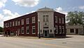
The Farmers and Merchants Bank Building in Monroe City.
-
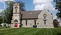
St. Jude's Episcopal Church in Monroe City.
-
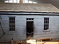
The small cabin where Mark Twain was born.
-
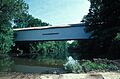
The historic Union Covered Bridge.
-
The historic Washington School in Monroe City.
