National Register of Historic Places listings in Morrill County, Nebraska facts for kids
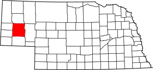
This is a list of the National Register of Historic Places listings in Morrill County, Nebraska.
This is intended to be a complete list of the properties and districts on the National Register of Historic Places in Morrill County, Nebraska, United States. The locations of National Register properties and districts for which the latitude and longitude coordinates are included below may be seen in a map.
There are 8 properties and districts listed on the National Register in the county.
Current listings
| Name on the Register | Image | Date listed | Location | City or town | Description | |
|---|---|---|---|---|---|---|
| 1 | Camp Clarke Bridge Site |
(#74001129) |
West of Bridgeport 41°41′24″N 103°10′43″W / 41.69°N 103.178611°W |
Bridgeport | Site of a wooden toll bridge built in 1875 to serve the Dakota gold fields. | |
| 2 | Chimney Rock National Historic Site |
(#66000116) |
3 miles (4.8 km) southwest of Bayard 41°42′09″N 103°20′49″W / 41.7025°N 103.346944°W |
Bayard | ||
| 3 | Courthouse and Jail House Rocks |
(#73001067) |
5 miles (8.0 km) south of Bridgeport 41°36′02″N 103°07′00″W / 41.600556°N 103.116667°W |
Bridgeport | ||
| 4 | Greenwood Stage Station |
(#12000106) |
Appr. location 41°30′07″N 103°04′57″W / 41.501994°N 103.0825°W |
Bridgeport | ||
| 5 | Morrill County Courthouse |
(#89002227) |
Main St. between 6th and 7th Sts. 41°40′07″N 103°06′00″W / 41.66864°N 103.10006°W |
Bridgeport | ||
| 6 | Mud Springs Station Archeological District |
(#73001068) |
County road 107 between 68 and 70 41°29′04″N 103°01′02″W / 41.4845°N 103.01712°W |
Dalton | Originally listed as "Mud Springs Pony Express Station Site"; boundaries increased on September 6, 2011 | |
| 7 | Rush Creek Battlefield |
(#11000619) |
Southern side of the Platte River at the mouth of Rush Creek 41°33′05″N 102°48′45″W / 41.551389°N 102.812500°W |
Broadwater | ||
| 8 | Schuetz Log Cabin |
(#11000105) |
HC 82 Box 103 41°29′57″N 103°05′17″W / 41.499167°N 103.088056°W |
Dalton | A settler family's log cabin, built during 1900-20. |

All content from Kiddle encyclopedia articles (including the article images and facts) can be freely used under Attribution-ShareAlike license, unless stated otherwise. Cite this article:
National Register of Historic Places listings in Morrill County, Nebraska Facts for Kids. Kiddle Encyclopedia.


