
National Register of Historic Places listings in Nevada County, California facts for kids

This article is about special places in Nevada County, California that are listed on the National Register of Historic Places. Think of this register as a very important list of buildings, sites, and objects across the United States that are worth saving because of their history. They might be important because of their architecture, what happened there, or who lived there.
Nevada County has 24 places on this list. One of them is even more special and is called a National Historic Landmark. These landmarks are the most important historic places in the country.
Contents
- Historic Places in Nevada County
- Boca Dam
- Bridgeport Covered Bridge
- Commercial Row-Brickelltown Historic District
- Davis Mill
- Donner Camp
- Empire Mine
- Foote's Crossing Road
- Grass Valley Public Library
- Kruger House
- Malakoff Diggins-North Bloomfield Historic District
- Martin Luther Marsh House
- Meadow Lake Petroglyphs
- Mount St. Mary's Academy and Convent
- National Exchange Hotel
- Nevada Brewery
- Nevada City Downtown Historic District
- Nevada City Firehouse No. 2
- Nevada City Free Public Library
- Nevada Theatre
- North Star House
- Ott's Assay Office
- Red Dog Townsite
- Aaron A. Sargent House
- Images for kids
Historic Places in Nevada County
Here are some of the cool historic spots you can find in Nevada County:
Boca Dam
The Boca Dam was added to the list on March 25, 1981. It's located at the south end of Boca Reservoir near Truckee. Dams are important for managing water and can be very old structures.
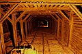
Bridgeport Covered Bridge
The Bridgeport Covered Bridge was listed on July 14, 1971. You can find it southwest of French Corral, stretching over the South Yuba River. Covered bridges are quite rare and beautiful, often built a long time ago to protect the wooden bridge from weather.
Commercial Row-Brickelltown Historic District
This historic district in Truckee was added on October 8, 2009. It includes buildings along the north side of Donner Pass Road. A "historic district" means a whole area with many old buildings that together tell a story about the past.
Davis Mill
The Davis Mill is located off North Bloomfield Road, about three miles northeast of Nevada City. It was listed on April 1, 2010. Mills were once very important for processing materials like lumber or grain.
Donner Camp
The Donner Camp is a very famous and important site, listed on October 15, 1966. It's about 2.6 miles west of Truckee on U.S. 40. This site is a National Historic Landmark because of its connection to the Donner Party, a group of pioneers who faced extreme challenges here in the winter of 1846–1847.
Empire Mine
The Empire Mine is a historic district southeast of Grass Valley at 338 East Empire Street. It was added to the list on December 9, 1977. This was one of California's oldest and richest gold mines. It operated for over 100 years!
Foote's Crossing Road
Foote's Crossing Road is found in the Tahoe National Forest near North Columbia. It was listed on January 29, 1981. Old roads like this can tell us a lot about how people traveled and transported goods in the past.
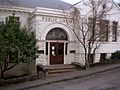
Grass Valley Public Library
The Grass Valley Public Library is at 207 Mill Street in Grass Valley. It became a historic place on March 26, 1992. Libraries are often important community buildings, and older ones can have beautiful architecture.
Kruger House
The Kruger House is located at 10292 Donner Pass Road in Truckee. It was listed on June 17, 1982. Historic houses give us a glimpse into how people lived many years ago.
Malakoff Diggins-North Bloomfield Historic District
This large historic district is near North Bloomfield and was listed on April 11, 1973. It's now part of the Malakoff Diggins State Historic Park. This area is famous for its "hydraulic mining" history, where powerful jets of water were used to wash away hillsides to find gold.
Martin Luther Marsh House
The Martin Luther Marsh House is at 254 Boulder Street in Nevada City. It was added to the register on April 11, 1973.
Meadow Lake Petroglyphs
The Meadow Lake Petroglyphs are ancient rock carvings located near French Lake. They were listed on May 6, 1971. Petroglyphs are drawings or carvings on rock, often made by early Native American people, and they are very important for understanding ancient cultures. The exact address is restricted to protect these fragile historical treasures.
Mount St. Mary's Academy and Convent
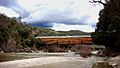
Mount St. Mary's Academy and Convent is located at Church and Chapel Streets in Grass Valley. It was listed on May 3, 1974. This building was once a school and a home for nuns, showing the history of education and religious communities in the area.
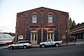
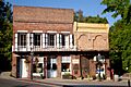
National Exchange Hotel
The National Exchange Hotel is at 211 Broad Street in Nevada City. It was listed on October 25, 1973. Historic hotels often served as central gathering places and show how towns grew.
Nevada Brewery
The Nevada Brewery is at 107 Sacramento Street in Nevada City. It was added on September 12, 1985. Breweries are part of the industrial history of a town.
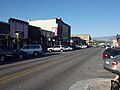
Nevada City Downtown Historic District
This large historic district in Nevada City was listed on September 23, 1985. It includes many streets like Spring, Bridge, Commercial, York, Washington, Coyote, and Main Streets. Walking through this district is like stepping back in time!
Nevada City Firehouse No. 2
The Nevada City Firehouse No. 2 is at 420 Broad Street in Nevada City. It was listed on May 3, 1974. Old firehouses are cool examples of community buildings and how towns protected themselves.
Nevada City Free Public Library
The Nevada City Free Public Library is at 211 North Pine Street in Nevada City. It became a historic place on December 10, 1990.
Nevada Theatre
The Nevada Theatre is at the corner of Broad and Bridge Streets in Nevada City. It was listed on March 14, 1973. This theatre is one of the oldest operating theatres in California, showing movies and live performances for many years.
North Star House
The North Star House is at 12075 Old Auburn Road in Grass Valley. It was added to the register on February 1, 2011. This house was designed by a famous architect and was part of the North Star Mine complex.
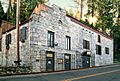
Ott's Assay Office
Ott's Assay Office is at 130 Main Street in Nevada City. It was listed on April 14, 1975. An "assay office" was where miners would bring their gold or other minerals to be tested for purity and value.
Red Dog Townsite
The Red Dog Townsite is near Nevada City and was listed on September 14, 2001. The exact location is restricted to protect the site. A "townsite" is the remains of an old town, often from the gold rush era, that is no longer active but still holds historical importance.
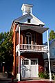
Aaron A. Sargent House
The Aaron A. Sargent House is at 449 Broad Street in Nevada City. It was listed on June 20, 1980. Aaron A. Sargent was an important figure in California's history, serving as a U.S. Senator.
Images for kids
-
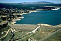
The Boca Dam, listed in 1981.
-
The historic Bridgeport Covered Bridge.
-
Buildings in the Commercial Row-Brickelltown Historic District in Truckee.
-
The Donner Camp, a National Historic Landmark.
-
A shaft at the Empire Mine, a rich gold mine.
-

The Grass Valley Public Library.
-
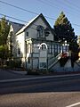
The Kruger House in Truckee.
-
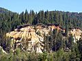
Malakoff Diggins, known for hydraulic mining.
-
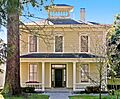
The Martin Luther Marsh House.
-
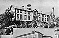
Mount St. Mary's Academy and Convent.
-
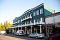
The National Exchange Hotel in Nevada City.
-
The historic Nevada Brewery.
-
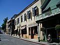
A street view of the Nevada City Downtown Historic District.
-
Nevada City Firehouse No. 2.
-
The Nevada City Free Public Library.
-
The historic Nevada Theatre.
-
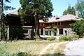
The North Star House in Grass Valley.
-
Ott's Assay Office.
-
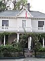
The Aaron A. Sargent House.


.JPG)

.jpg)


