
National Register of Historic Places listings in Onslow County, North Carolina facts for kids

This article is about special places and areas in Onslow County, North Carolina that are listed on the National Register of Historic Places. This register is like a national list of important buildings, sites, and districts that are worth saving because of their history. These places tell us stories about the past and help us understand how people lived long ago.
Contents
What is the National Register of Historic Places?
The National Register of Historic Places is the official list of the United States' historic places that are considered worthy of preservation. It's managed by the National Park Service. When a place is added to this list, it means it's important to the history, architecture, archaeology, engineering, or culture of the country. It helps protect these places and makes people more aware of their value.
Why are these places important?
These historic places are like time capsules! They show us how people lived, worked, and built things in the past. By protecting them, we can learn from history and make sure future generations can also experience these important sites. They help us understand the unique story of Onslow County and North Carolina.
Historic Places in Onslow County
Onslow County has many interesting places that are part of the National Register. These include old houses, farms, and even whole neighborhoods called "historic districts." Each one has its own unique story.
Houses and Plantations
Many of the listed places are old homes or large farms, often called plantations, that show how people lived in earlier times.
Alum Spring
Located near Catherine Lake, North Carolina, Alum Spring was added to the list in 1990. It's a natural spring that has been important to the area for a long time.
Avirett-Stephens Plantation
This historic plantation is found near Richlands, North Carolina. It was recognized in 1991 and gives us a look into the farming history of the region.
William Edward Mattocks House
In Swansboro, North Carolina, you can find the William Edward Mattocks House. This house, listed in 1989, is a great example of the architecture from its time.
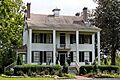
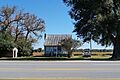
Palo Alto Plantation
Near Palopato, North Carolina, the Palo Alto Plantation was listed in 1979. It's one of the older listings in the county and has a rich history.
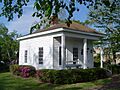
Pelletier House and Wantland Spring
This historic house and nearby spring are located in Jacksonville, North Carolina. They were added to the register in 1989, showing the early development of the city.
Taylor Farm
Another important farm, the Taylor Farm, is in Richlands, North Carolina. It was recognized in 1999 for its historical significance.
Historic Districts
Sometimes, it's not just one building that's important, but a whole group of buildings or a neighborhood. These are called historic districts.
Catherine Lake Historic District
This district, located where two roads meet in Catherine Lake, North Carolina, was listed in 1989. It includes several historic buildings that together tell a story.
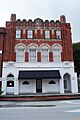
Bank of Onslow and Jacksonville Masonic Temple
In Jacksonville, North Carolina, this historic district includes two important buildings: the Bank of Onslow and the Jacksonville Masonic Temple. They were added to the list in 1989.
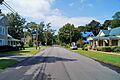
Mill Avenue Historic District
Also in Jacksonville, North Carolina, the Mill Avenue Historic District is a larger area with many historic buildings. It was recognized in 1990.
Richlands Historic District
The town of Richlands, North Carolina has its own historic district, listed in 1990. It covers a large part of the old town center.
Southwest Historic District
Near Waltons Store, North Carolina, this district was added in 1989. It highlights the historical development of that area.
Swansboro Historic District
The town of Swansboro, North Carolina has a beautiful historic district, recognized in 1990. It includes many buildings near the water and shows the town's long history.
Venters Farm Historic District
This district near Richlands, North Carolina was listed in 1987. It focuses on the historic farm buildings and land that show how farming shaped the area.
Other Notable Sites
Onslow County also has other unique historic sites.
Futral Family Farm
Near Fountaintown, North Carolina, the Futral Family Farm was listed in 1989. It represents the agricultural heritage of the county.
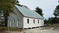
Yopps Meeting House
Located in Sneads Ferry, North Carolina, Yopps Meeting House was added to the register in 1999. It's a significant historical building that served as a community gathering place.
Images for kids
-
Bank of Onslow and Jacksonville Masonic Temple
-
Mill Avenue Historic District
-
Palo Alto Plantation
-
Pelletier House and Wantland Spring
-
Venters Farm Historic District
-
Yopps Meeting House


