Swansboro, North Carolina facts for kids
Quick facts for kids
Swansboro
|
|||
|---|---|---|---|

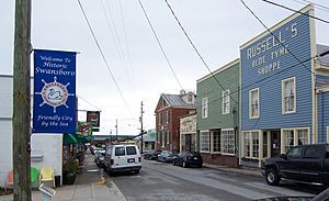
Downtown Swansboro
|
|||
|
|||
| Motto(s):
"The Friendly City by the Sea"
|
|||

Location within the state of North Carolina
|
|||
| Country | United States | ||
| State | North Carolina | ||
| County | Onslow | ||
| Area | |||
| • Total | 2.38 sq mi (6.16 km2) | ||
| • Land | 2.23 sq mi (5.79 km2) | ||
| • Water | 0.14 sq mi (0.37 km2) | ||
| Elevation | 30 ft (9 m) | ||
| Population
(2020)
|
|||
| • Total | 3,744 | ||
| • Density | 1,675.17/sq mi (646.90/km2) | ||
| Time zone | UTC-5 (Eastern (EST)) | ||
| • Summer (DST) | UTC-4 (EDT) | ||
| ZIP code |
28584
|
||
| Area codes | 910, 472 | ||
| FIPS code | 37-66360 | ||
| GNIS feature ID | 2406700 | ||
Swansboro is a fun resort town located in Onslow County, North Carolina. It sits right along the beautiful Crystal Coast. In 2020, about 3,744 people lived there. Swansboro is often called "The Friendly City by the Sea."
Contents
Discover Swansboro's Past
Swansboro began as a small settlement around a large farm owned by Theophilus Weeks. In 1783, it officially became a town. The town was named after Samuel Swann, who was an important leader in the North Carolina government. He lived in Onslow County.
Early Innovations and Local Traditions
In 1818, a man named Otway Burns built the Prometheus in Swansboro. This was the very first steamboat ever made in North Carolina. Swansboro is also famous for its annual Mullet Festival. This festival was started by a popular mayor, M.N. Lisk. It is one of the oldest seafood festivals on the coast of North Carolina.
Swansboro in Pop Culture
The town of Swansboro is even featured in a book! It is the setting for the novel The Guardian by famous author Nicholas Sparks.
Protecting Swansboro's Heritage
The historic area of Swansboro, known as the Swansboro Historic District, was added to the National Register of Historic Places in 1990. This means it's a special place that is protected for its history.
Facing Natural Challenges
In 2018, Swansboro was hit very hard by Hurricane Florence. A record-breaking amount of rain fell in the town, over 30 inches (77 cm). This was the most rain ever recorded in North Carolina from a hurricane.
Swansboro's Location and Size
Swansboro is a coastal town. It has a total area of about 1.3 square miles (3.4 square kilometers). Most of this area is land, about 1.2 square miles (3.1 square kilometers). A small part, about 0.1 square miles (0.26 square kilometers), is water.
Who Lives in Swansboro?
| Historical population | |||
|---|---|---|---|
| Census | Pop. | %± | |
| 1850 | 801 | — | |
| 1870 | 141 | — | |
| 1880 | 128 | −9.2% | |
| 1890 | 233 | 82.0% | |
| 1900 | 265 | 13.7% | |
| 1910 | 390 | 47.2% | |
| 1920 | 420 | 7.7% | |
| 1930 | 394 | −6.2% | |
| 1940 | 454 | 15.2% | |
| 1950 | 559 | 23.1% | |
| 1960 | 1,104 | 97.5% | |
| 1970 | 1,207 | 9.3% | |
| 1980 | 976 | −19.1% | |
| 1990 | 1,165 | 19.4% | |
| 2000 | 1,426 | 22.4% | |
| 2010 | 2,663 | 86.7% | |
| 2020 | 3,744 | 40.6% | |
| U.S. Decennial Census | |||
As of the 2020 census, there were 3,744 people living in Swansboro. These people made up 1,360 households, and 755 of those were families.
Swansboro's Diverse Community (2020 Census)
| Race | Number | Percentage |
|---|---|---|
| White (non-Hispanic) | 3,091 | 82.56% |
| Black or African American (non-Hispanic) | 121 | 3.23% |
| Native American | 14 | 0.37% |
| Asian | 77 | 2.06% |
| Pacific Islander | 4 | 0.11% |
| Other/Mixed | 201 | 5.37% |
| Hispanic or Latino | 236 | 6.3% |
Schools in Swansboro
Swansboro has several schools for students of all ages:
- Queens Creek Elementary School
- Swansboro Elementary School
- Swansboro Middle School
- Swansboro High School
Fun Things to Do in Swansboro
Swansboro is a great place for visitors! It's located right across the Intracoastal Waterway from Hammocks Beach State Park. This makes it a popular spot for tourists, people who love the outdoors, and those who enjoy fishing.
Community Events and Festivals
The Rotary Club of Swansboro is very active in the community. They often host events like the yearly King Mackerel Tournament. The Mullet Festival is the most famous and longest-running annual event. It has been happening for 68 years and includes a parade, street vendors, and live music.
Famous People from Swansboro
- Otway Burns (around 1775–1850) was born near Swansboro. He was a privateer (a type of sailor who attacked enemy ships) and later became a North Carolina State Senator.
See also
 In Spanish: Swansboro para niños
 | Kyle Baker |
 | Joseph Yoakum |
 | Laura Wheeler Waring |
 | Henry Ossawa Tanner |


