National Register of Historic Places listings in Orange County, Virginia facts for kids
Imagine a special list that helps protect important places in the United States! This list is called the National Register of Historic Places. It's like a hall of fame for buildings, sites, and areas that tell us a lot about history. In Orange County, Virginia, there are many cool places on this list. These spots are kept safe so future generations can learn from them.
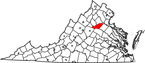
Orange County has 36 places listed on the National Register. One of them is extra special and is called a National Historic Landmark. This means it's super important to the history of the entire country!
Historic Treasures in Orange County
Orange County is full of amazing historic places. Let's explore some of them!
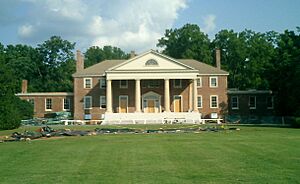
Montpelier: Home of a President
One of the most important places in Orange County is Montpelier. This was the home of James Madison, who was the fourth President of the United States! He is often called the "Father of the Constitution" because he helped write the U.S. Constitution. Montpelier is so important that it's a National Historic Landmark. You can visit it and learn about President Madison's life and how he helped shape our country. It's located about 4 miles west of Orange on Virginia Route 20.
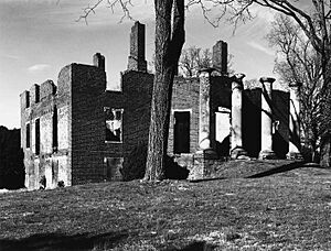
Barboursville: A Grand Ruin
Another fascinating spot is Barboursville. This was once a beautiful mansion designed by Thomas Jefferson, another U.S. President! Sadly, it burned down in 1884. Today, you can see the impressive ruins of the old house. It's a powerful reminder of the past and how things change over time. Barboursville is located south of the junction of Routes 777 and 678.
The Exchange Hotel: A Place of Many Stories
In Gordonsville, Virginia, you'll find the Exchange Hotel. This building has seen a lot of history! It started as a hotel and a hospital during the American Civil War. Many soldiers were cared for here. Later, it became a place where people could stay and rest during their travels. It's a great example of how buildings can have many different uses over the years. The Exchange Hotel is on South Main Street in Gordonsville.
Orange County Courthouse: A Center of Justice
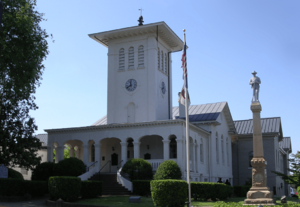
The Orange County Courthouse is a very important building in the town of Orange, Virginia. Courthouses are places where laws are upheld and justice is served. This building has been a central part of the community for a long time, witnessing many important decisions and events. It stands at the corner of Madison Road and North Main Street.
Germanna Site: Digging Up the Past
The Germanna Site is an archaeological site near Culpeper, Virginia. This means it's a place where scientists dig up old objects and structures to learn about people who lived there long ago. It was one of the first German settlements in Virginia, founded in the early 1700s. Exploring sites like Germanna helps us understand what life was like for early settlers. It's located on Germanna Highway.
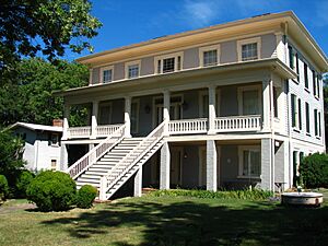
Black Meadow: A Glimpse into Farm Life
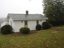
Black Meadow is a historic property near Gordonsville, Virginia. It includes buildings that show what a large farm was like in the 1800s. One of the buildings is a cottage from 1856, which was used by people who worked on the farm. Places like Black Meadow help us understand the daily lives of people from different times in history. It is located on Wolf Trap Drive.
Other Notable Places
Many other places in Orange County are also on the National Register. These include:
- Ballard-Marshall House: A historic home in Orange.
- Berry Hill: Another historic property south of Orange.
- Bloomsbury: A historic estate west of Orange.
- Burlington: Located near Barboursville.
- Chestnut Hill: A historic house in Orange.
- Frascati: A historic home south of Somerset, Virginia.
- Gordonsville Historic District: An area in Gordonsville with many historic buildings.
- Greenwood: A historic property in Orange.
- Grelen: Another historic site in Orange.
- Hampstead Farm Archeological District: An area with important archaeological findings near Barboursville.
- Hare Forest Farm: A historic farm near Orange.
- Lessland: Located near Culpeper, Virginia.
- Madison-Barbour Rural Historic District: A large historic area covering parts of Orange County.
- Mayhurst: A historic inn near Orange.
- Mount Calvary Baptist Church: A historic church in Orange.
- Mount Sharon: A historic property in Orange.
- Orange Commercial Historic District: The historic downtown area of Orange.
- Orange High School: The old high school building in Orange.
- Orange Springs: A historic site near Unionville, Virginia.
- Rapidan Historic District: A historic area in Rapidan, Virginia.
- Rebel Hall: A historic home in Orange.
- Rocklands: A historic property north of Gordonsville.
- Rockwood: Located near Montpelier Station, Virginia.
- St. Thomas Church: A historic church in Orange.
- Somerset Christian Church: A historic church in Old Somerset, Virginia.
- Tetley: A historic property east of Somerset.
- Waddell Memorial Presbyterian Church: A historic church near Rapidan.
- Willow Grove: A historic home near Madison Mills, Virginia.
- Williston: A historic property in Orange.
These places help us remember and learn about the rich history of Orange County and Virginia!
Images for kids


