
Rapidan, Virginia facts for kids
Quick facts for kids
Rapidan, Virginia
|
|
|---|---|

Rapidan, Virginia
Location in Virginia

Rapidan, Virginia
Location in the United States
|
|
| Country | |
| State | |
| County | Culpeper & Orange |
| Established | Mid- to late 1700s |
| Area | |
| • Total | 49 sq mi (130 km2) |
| Elevation | 430 ft (131 m) |
| Population
(2010)
|
|
| • Total | 1,469 |
| • Density | 30/sq mi (10/km2) |
| Time zone | UTC-5 (EST) |
| • Summer (DST) | UTC-4 (EDT) |
| ZIP code |
22733
|
| Area code(s) | 540 |
Rapidan is a small community in Virginia, USA. It's not a city or town with its own government. Instead, it's an unincorporated community located across two counties: Culpeper and Orange. Rapidan is about 8 kilometers (5 miles) northeast of the Town of Orange.
The community started in the late 1700s. It grew up around a mill called Waugh's Ford Mill. This mill was located on both sides of the Rapidan River.
Contents
A Look Back: Rapidan's History
In 1854, the Orange and Alexandria Railroad built train tracks through the area. A post office was then built near the river crossing. Because of the new train station, the community's name changed to Rapid Ann Station. Milling, which is the process of grinding grain into flour, was a very important business here until the mid-1900s.
Rapidan During the Civil War
Rapidan's location was very important during the Civil War. Being near both a railroad and a river made it a target. Several attacks happened here. Willis's Mill, which was built around 1772, was burned down. Many homes and other buildings were also destroyed. However, the miller's house was saved.
After the War: Rebuilding and Renaming
After the Civil War, the railroad was rebuilt. Rapid Ann Station became important again for shipping goods. It was especially key for sending out lumber and wood products. In 1886, the community's name changed one more time to its current name, Rapidan.
Exploring Rapidan's Historic Places
In 1987, a special area called the Rapidan Historic District was created. This district covers about 74 hectares (182 acres). It includes 35 important old buildings. This district was added to both the Virginia Landmarks Register and the National Register of Historic Places. One of the important buildings in the district is the Waddell Memorial Presbyterian Church.
Outside of this main historic district, there's another interesting old building. It's an 18th-century farmhouse called Locust Grove. It's also known as Goodwin Farm. This farmhouse was added to the Virginia Landmarks Register and the National Register of Historic Places in 1985.
-
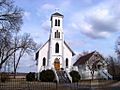
Emmanuel Episcopal Church
-
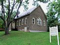
Lower Rapidan Baptist Church
-
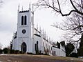
Waddell Memorial Presbyterian Church
-
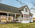
Rapidan Passenger Depot


Rapidan's Climate
The weather in Rapidan has hot and humid summers. The winters are usually mild to cool. This type of weather is called a humid subtropical climate. On climate maps, it's often shown as "Cfa."
Learning in Rapidan
Rapidan has a history related to education. In 1948, the George Washington Carver Regional High School opened here. At that time, schools in the United States were often segregated. This meant Black students had separate schools. George Washington Carver was for Black students from Culpeper, Orange, Madison, and Rappahannock Counties.
In 1968, schools began to desegregate, meaning students of all races could attend the same schools. George Washington Carver High School then became the Piedmont Technical Education Center. In 1992, its name changed again to the George Washington Carver-Piedmont Technical Education Center. This center helps students learn technical skills.
