
National Register of Historic Places listings in Orangeburg County, South Carolina facts for kids

This page lists cool and important places in Orangeburg County, South Carolina, that are part of the National Register of Historic Places. This is a special list in the United States that helps protect buildings, sites, and objects that are important to history. Think of it like a hall of fame for historic spots!
You can find 41 places and areas from Orangeburg County on this list right now. There were also 2 other places that used to be on the list but are not anymore.
Awesome Historic Places in Orangeburg County
| Name on the Register | Image | Date listed | Location | City or town | Description | |
|---|---|---|---|---|---|---|
| 1 | All Star Bowling Lane |
_sign_from_SW_1.JPG) |
(#96000837) |
559 E. Russell St. 33°29′34″N 80°51′34″W / 33.4929°N 80.859515°W |
Orangeburg | This bowling alley was a place where important events happened in 1968, as people protested for equal rights. |
| 2 | Amelia Street Historic District |
(#85002322) |
Amelia St. between Treadwell St. and Summers Ave. 33°29′39″N 80°51′37″W / 33.494167°N 80.860278°W |
Orangeburg | A historic area with many old buildings. | |
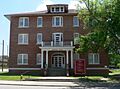
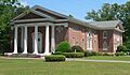
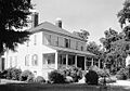
| 3 | F.H.W. Briggman House |
 |
(#85002337) |
156 Amelia St. 33°29′25″N 80°51′56″W / 33.490261°N 80.865601°W |
Orangeburg | A beautiful old house. |
| 4 | Donald Bruce House |
(#78002528) |
Southeast of Orangeburg on U.S. Route 301 33°28′36″N 80°48′53″W / 33.476667°N 80.814722°W |
Orangeburg | Another historic home in the area. | |
| 5 | Cattle Creek Campground |
(#83002204) |
Off South Carolina Highway 210 33°19′20″N 80°45′08″W / 33.322222°N 80.752222°W |
Rowesville | A historic campground. | |
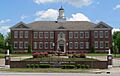
| 6 | Claflin College Historic District |
.jpg) |
(#85002324) |
On a portion of the Claflin College campus 33°29′51″N 80°51′18″W / 33.4975°N 80.855°W |
Orangeburg | This district includes historic buildings on the Claflin University campus. |
| 7 | Cope Depot |
(#01000298) |
Cope Rd. 33°22′39″N 81°00′28″W / 33.3775°N 81.007778°W |
Cope | An old train station in Cope. | |
| 8 | Dantzler Plantation |
(#07000098) |
2755 Vance Rd. 33°24′56″N 80°30′23″W / 33.415608°N 80.506383°W |
Holly Hill | A historic plantation site. | |
| 9 | Dixie Library Building |
(#85002336) |
Corner of Bull and Middleton Sts. 33°29′33″N 80°52′06″W / 33.4925°N 80.868333°W |
Orangeburg | An old library building. | |
| 10 | Dukes Gymnasium |
 |
(#85002321) |
South Carolina State University campus 33°29′50″N 80°51′01″W / 33.497326°N 80.850374°W |
Orangeburg | This gym is on the campus of South Carolina State University. |
| 11 | East Russell Street Area Historic District |
(#85002335) |
Along sections of E. Russell St. between Watson and Clarendon Sts., and along portions of Oakland Pl. and Dickson and Whitman Sts. 33°29′36″N 80°51′04″W / 33.493333°N 80.851111°W |
Orangeburg | A historic neighborhood on East Russell Street. | |
| 12 | Ellis Avenue Historic District |
(#85002327) |
Along portions of Ellis Ave. between Summers Ave. and Wilson St. 33°29′53″N 80°51′47″W / 33.498056°N 80.863056°W |
Orangeburg | Another historic area along Ellis Avenue. | |
| 13 | Enterprise Cotton Mills Building |
_from_NW_1.JPG) |
(#85002340) |
U.S. Route 21 33°29′14″N 80°51′14″W / 33.487161°N 80.853977°W |
Orangeburg | This building was once a cotton mill. |
| 14 | Eutaw Springs Battleground Park |
 |
(#70000593) |
2 miles east of Eutawville on South Carolina Highways 6 and 45 33°24′30″N 80°17′57″W / 33.408333°N 80.299167°W |
Eutawville | This park is where the Battle of Eutaw Springs happened during the Revolutionary War. |
| 15 | Maj. John Hammond Fordham House |
(#85002341) |
415 Boulevard 33°29′58″N 80°51′20″W / 33.499444°N 80.855556°W |
Orangeburg | The historic home of Major John Hammond Fordham. | |
| 16 | Great Branch Teacherage |
 |
(#07001112) |
2890 Neeses Highway 33°31′20″N 81°00′13″W / 33.522244°N 81.0036°W |
Orangeburg | This building was once a home for teachers. |
| 17 | Hodge Hall |
 |
(#85002320) |
South Carolina State University campus 33°29′51″N 80°51′06″W / 33.497615°N 80.851643°W |
Orangeburg | Another important building on the South Carolina State University campus. |
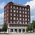
| 18 | Hotel Eutaw |
 |
(#85002318) |
Russell and Centre Sts. 33°29′29″N 80°51′38″W / 33.491481°N 80.860511°W |
Orangeburg | A historic hotel. |
| 19 | Lowman Hall, South Carolina State College |
 |
(#85002346) |
South Carolina State College campus 33°29′43″N 80°51′14″W / 33.495323°N 80.853790°W |
Orangeburg | Lowman Hall is part of the South Carolina State University campus. |
| 20 | Alan Mack Site (38OR67) |
 |
(#86000044) |
Address Restricted |
Orangeburg | This site is a special place that is kept secret to protect it. |
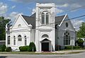
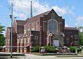
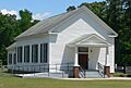
| 21 | Mt. Pisgah Baptist Church |
_from_S_1.JPG) |
(#85002342) |
310 Green 33°29′34″N 80°51′55″W / 33.492891°N 80.865154°W |
Orangeburg | A historic church building. |
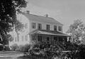
| 22 | Numertia Plantation |
.jpg) |
(#82003898) |
East of Eutawville 33°23′00″N 80°16′51″W / 33.383333°N 80.280833°W |
Eutawville | An old plantation house. |
| 23 | Orangeburg City Cemetery |
 |
(#96001025) |
Junction of Bull and Windsor Sts. 33°29′21″N 80°52′15″W / 33.489154°N 80.870756°W |
Orangeburg | This cemetery is a historic burial ground in Orangeburg. |
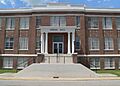
| 24 | Orangeburg County Fair Main Exhibit Building |
|
(#85002344) |
U.S. Route 21 33°28′49″N 80°51′10″W / 33.480274°N 80.852768°W |
Orangeburg | The main building of the Orangeburg County Fair. |
| 25 | Orangeburg County Jail |
 |
(#73001724) |
44 Saint John St. 33°29′22″N 80°51′42″W / 33.489540°N 80.861552°W |
Orangeburg | The old jail building for Orangeburg County. |
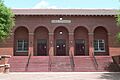
| 26 | Orangeburg Downtown Historic District |
 |
(#85002317) |
Russell, Broughton, Middleton, Church, Meeting, St. John, Hampton, and Amelia Sts. around the public square 33°29′24″N 80°51′49″W / 33.49°N 80.863611°W |
Orangeburg | This area covers the historic downtown part of Orangeburg. |
| 27 | Providence Methodist Church |
_from_S_2.JPG) |
(#08001395) |
4833 Old State Rd. 33°23′33″N 80°32′26″W / 33.392529°N 80.540493°W |
Holly Hill | A historic church in Holly Hill. |
| 28 | St. Julien Plantation |
(#80003693) |
South Carolina Highway 6 33°24′35″N 80°21′11″W / 33.409722°N 80.353056°W |
Eutawville | Another historic plantation site. | |
| 29 | South Carolina State College Historic District |
(#96001024) |
300 College St. 33°29′46″N 80°51′11″W / 33.496111°N 80.853056°W |
Orangeburg | This district includes many historic buildings on the South Carolina State University campus. | |
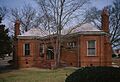
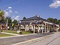
| 30 | Southern Railway Passenger Depot |
 |
(#73001723) |
110 N. Main St. 33°15′04″N 80°48′57″W / 33.251111°N 80.815833°W |
Branchville | The old train station in Branchville. |
| 31 | Springfield High School |
(#01000313) |
Brodie St., between South Carolina Highway 4 and Georgia St. 33°29′44″N 81°16′27″W / 33.495556°N 81.274167°W |
Springfield | The historic high school building in Springfield. | |
| 32 | William P. Stroman House |
(#96000836) |
1017 N. Boulevard 33°30′12″N 80°51′34″W / 33.503333°N 80.859444°W |
Orangeburg | The historic home of William P. Stroman. | |
| 33 | Tingley Memorial Hall, Claflin College |
 |
(#83002205) |
College Ave. 33°29′54″N 80°51′16″W / 33.498414°N 80.854333°W |
Orangeburg | Tingley Memorial Hall is a historic building at Claflin University. |
| 34 | Treadwell Street Historic District |
(#85002315) |
Along portions of Treadwell and Amelia Sts. 33°29′45″N 80°51′30″W / 33.495833°N 80.858333°W |
Orangeburg | A historic area along Treadwell and Amelia Streets. | |
| 35 | Trinity Lutheran Church |
(#08000721) |
390 Hampton St. 33°31′59″N 80°34′17″W / 33.533014°N 80.571467°W |
Elloree | A historic Lutheran church. | |
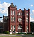
| 36 | Trinity Methodist Episcopal Church |
_from_SE_2.JPG) |
(#94001053) |
185 Boulevard NE. 33°29′44″N 80°51′23″W / 33.495569°N 80.856505°W |
Orangeburg | A historic Methodist church in Orangeburg. |
| 37 | White House United Methodist Church |
_from_SW_1.JPG) |
(#74001872) |
Near intersection of U.S. Highway 301 and Interstate 26 33°27′35″N 80°43′05″W / 33.459763°N 80.718082°W |
Orangeburg | This church is known for its historic importance. |
| 38 | Whitman Street Area Historic District |
(#85002326) |
Along sections of Whitman, Elliot, and E. Russell Sts. 33°29′28″N 80°51′29″W / 33.491111°N 80.858056°W |
Orangeburg | A historic neighborhood on Whitman Street. | |
| 39 | Williams Chapel A.M.E. Church |
_from_NW_1.JPG) |
(#85002345) |
1198 Glover St. 33°29′11″N 80°51′38″W / 33.486266°N 80.860517°W |
Orangeburg | A historic African Methodist Episcopal church. |
| 40 | Willow Consolidated High School |
(#06000581) |
2750 Cope Rd. 33°26′53″N 81°09′20″W / 33.448056°N 81.155556°W |
Norway | The old Willow Consolidated High School building. |
Places That Were Once Historic
| Name on the Register | Image | Date listed | Date removed | Location | City or town | Summary | |
|---|---|---|---|---|---|---|---|
| 1 | Gilmore House |
(#88001470) |
|
State St. & Eutaw Rd. |
Holly Hill | This house was taken off the list because it was torn down. | |
| 2 | Rocks Plantation |
 |
(#76001709) |
|
Near SC Highway 6 |
Eutawville | This plantation was removed from the list after it burned down. |
Images for kids
-
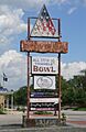
The sign for the All Star Bowling Lane.
-
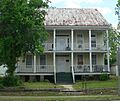
The F.H.W. Briggman House.
-
Lee Library at Claflin College.
-
The entrance to Dukes Gymnasium.
-
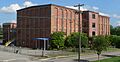
The Enterprise Cotton Mills Building, also known as the Zeus building.
-
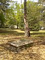
A view of Eutaw Springs Battleground Park.
-
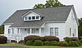
The Great Branch Teacherage.
-
Hodge Hall at South Carolina State University.
-
The historic Hotel Eutaw.
-
Lowman Hall at South Carolina State University.
-

An image representing a restricted address.
-
Mt. Pisgah Baptist Church.
-
Numertia Plantation House.
-
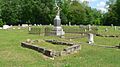
A view inside Orangeburg City Cemetery.
-
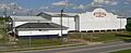
The Orangeburg County Fair Main Exhibit Building.
-
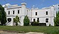
The old Orangeburg County Jail.
-
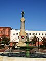
A Confederate memorial in the Orangeburg Downtown Historic District.
-
Providence Methodist Church.
-
The Southern Railway Passenger Depot in Branchville.
-
Tingley Memorial Hall at Claflin University.
-
Trinity Methodist Episcopal Church.
-
White House United Methodist Church.
-
Williams Chapel A.M.E. Church.
-
The Rocks Plantation, which is no longer standing.
