
National Register of Historic Places listings in Pottawattamie County, Iowa facts for kids

Have you ever wondered about the old buildings and places in your town? Many of them have amazing stories! The National Register of Historic Places is a special list in the United States. It helps protect places that are important to history, architecture, or culture. When a place is on this list, it means it's worth saving for future generations to enjoy.
This article is about the cool historic places in Pottawattamie County, Iowa. These places are all on the National Register of Historic Places. There are 39 of them! One of these is even a National Historic Landmark, which is a very special honor. A few other places used to be on the list but have since been removed. Let's explore some of these neat spots!
Contents
- Historic Buildings and Homes
- Homes with History
- Important Public and Commercial Buildings
- Bennett Building
- Chevra B'nai Yisroel Synagogue
- Chicago, Rock Island & Pacific Railroad Passenger Depot
- Council Bluffs Free Public Library
- German Bank Building of Walnut, Iowa
- Hotel Chieftain
- Hughes-Irons Motor Company
- McCormick Harvesting Machine Company Building
- Pioneer Implement Company
- Pottawattamie County Jail
- Pottawattamie County Sub Courthouse
- Reverend Little's Young Ladies Seminary
- St. Peter's Church and Rectory
- Sandwich–Marseilles Manufacturing Building
- State Savings Bank
- Y.M.C.A. Building
- Historic Districts and Other Sites
- Former Listings
- Images for kids
Historic Buildings and Homes
Pottawattamie County has many old buildings and houses. They tell us about how people lived and worked long ago.
Homes with History
Many beautiful old houses in the county are on the list. They show different styles of architecture from the past.
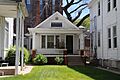
August Beresheim House
The August Beresheim House is located at 621 3rd Street in Council Bluffs, Iowa. It was added to the list in 1976. This house is a great example of older homes in the area.
Jean and Inez Bregant House
You can find the Jean and Inez Bregant House at 517 S. 4th Street in Council Bluffs. It joined the list in 2013. It's another interesting old home.
Thomas E. Cavin House
The Thomas E. Cavin House is at 150 Park Avenue in Council Bluffs. It became historic in 1984. Imagine living in a house like this!

Grenville M. Dodge House
The Grenville M. Dodge House is at 605 S. 3rd Street in Council Bluffs. It was added to the list way back in 1966. This house is super important! It's a National Historic Landmark. Grenville M. Dodge was a famous general and railroad builder. His home is a must-see.

Martin Hughes House
The Martin Hughes House is at 903 3rd Street in Council Bluffs. It was listed in 1984. This house has a unique design.

Thomas Jefferis House
Located at 523 6th Avenue in Council Bluffs, the Thomas Jefferis House was added in 1979. It's a charming old home.

Charles Henry and Charlotte Norton House
In Avoca, Iowa, you'll find the Charles Henry and Charlotte Norton House at 401 N. Chestnut Street. It was listed in 2004. It's a beautiful example of homes from its time.

John J. and Agnes Shea House
The John J. and Agnes Shea House is at 309 S. 8th Street in Council Bluffs. It became historic in 1995. This house adds to the rich history of the area.

Lysander Tulleys House
At 151 Park Avenue in Council Bluffs is the Lysander Tulleys House. It was listed in 1979. It's right next to the Thomas E. Cavin House.

O.P. Wickham House
The O.P. Wickham House is at 616 S. 7th Street in Council Bluffs. It was added in 1979. This house has a classic look.

Wickham-De Vol House
Another interesting home is the Wickham-De Vol House at 332 Willow Avenue in Council Bluffs. It was listed in 1995.

Important Public and Commercial Buildings
These buildings played a big role in the community's past. They include places where people worked, learned, or gathered.
Bennett Building
The Bennett Building is at 405 West Broadway in Council Bluffs. It was listed in 2001. This building was important for businesses in the past.

Chevra B'nai Yisroel Synagogue
This historic synagogue is at 618 Mynster Street in Council Bluffs. It was added in 2007. It's a place of worship with a long history.

Chicago, Rock Island & Pacific Railroad Passenger Depot
This old train station is now the RailsWest Railroad Museum. It's at 1512 S. Main Street in Council Bluffs. It was listed in 1995. Trains were super important for travel and trade back then!

Council Bluffs Free Public Library
The old library building at 200 Pearl Street in Council Bluffs became historic in 1999. It's now part of the Union Pacific Railroad Museum. Imagine all the books that were once here!

German Bank Building of Walnut, Iowa
In Walnut, Iowa, you can find the old German Bank Building. It's at the junction of Highland and Central Streets. It was listed in 1991. This building shows what banks looked like long ago.

Hotel Chieftain
The Hotel Chieftain is at 38 Pearl Street in Council Bluffs. It was added to the list in 2014. This hotel once welcomed many travelers.

Hughes-Irons Motor Company
This building at 149-161 W. Broadway in Council Bluffs was listed in 2011. It was once a motor company, showing the early days of cars.

McCormick Harvesting Machine Company Building
At 1001 S. 6th Street in Council Bluffs, this building was listed in 2012. It was used by a company that made farm machines. This was very important for farmers.

Pioneer Implement Company
Another building related to farming is the Pioneer Implement Company. It's at 1000 S. Main Street in Council Bluffs. It was listed in 2008. These companies helped farmers grow food for everyone.

Pottawattamie County Jail
The old Pottawattamie County Jail is at 226 Pearl Street in Council Bluffs. It became historic in 1972. It's a unique building that once held prisoners.

Pottawattamie County Sub Courthouse
In Avoca, the Pottawattamie County Sub Courthouse on Elm Street was listed in 1981. Courthouses are important places where laws are made and justice is served.

Reverend Little's Young Ladies Seminary
This interesting building at 541 6th Avenue in Council Bluffs was listed in 1982. It was once a school for young ladies.

St. Peter's Church and Rectory
St. Peter's Church and Rectory are at 1 Bluff Street in Council Bluffs. They were listed in 1992. This church has been a spiritual center for many years.

Sandwich–Marseilles Manufacturing Building
This building at 1216–1230 S. Main Street in Council Bluffs was listed in 2014. It was once a manufacturing building, making things for people.

State Savings Bank
The State Savings Bank building at 509 W. Broadway in Council Bluffs was listed in 1984. It's another example of a historic bank building.

Y.M.C.A. Building
The Y.M.C.A. Building at 628 1st Avenue in Council Bluffs was listed in 1979. The YMCA has helped many young people over the years.

Historic Districts and Other Sites
Sometimes, it's not just one building that's historic, but a whole area! These are called historic districts.
Historic Districts to Explore
These districts are groups of buildings that together tell a story about the past.
100 Block of West Broadway Historic District
This district includes parts of W. Broadway, 1st Street, and 4th Street in Council Bluffs. It was listed in 2002. This area has many old shops and buildings.

Haymarket Commercial Historic District
The Haymarket Commercial Historic District is on S. Main Street in Council Bluffs. It was listed in 1985. This area was once a busy place for trade and business.

Lincoln-Fairview Historic District
This large district in Council Bluffs was listed in 2007. It's roughly bounded by W. Kanesville Boulevard, Oakland Avenue, Fairview Cemetery, and N. 1st Street. It has many historic homes and buildings.

Park/Glen Avenues Historic District
This district in Council Bluffs includes parts of Glen Avenue, Park Avenue, W. Pierce, and Huntington. It was listed in 2010. It's a neighborhood with many historic homes.

South 8th Street Historic District
This district in Council Bluffs was listed in 2020. It's bounded by South 7th Street, South 8th Street, 1st Avenue, and 7th Avenue, with a segment along 2nd Avenue extending to South 10th Street. It's a vibrant historic neighborhood.
Willow-Bluff-3rd Street Historic District
This district in Council Bluffs was listed in 2005. It's roughly bounded by Worth, High School Avenue, Clark Avenue, and the western side of Bluff Street. It's another area with many historic buildings.

Unique Historic Sites
Some places are special because of their unique purpose or design.
Carstens Farmstead
The Carstens Farmstead is south of Shelby, Iowa on Iowa Highway 168. It was listed in 1979. This old farm shows how people lived and worked on farms long ago.
Ruth Anne Dodge Memorial
This beautiful memorial is in Fairview Cemetery in Council Bluffs. It was listed in 1980. It's a peaceful and artistic tribute.

Eckle Round Barn
The Eckle Round Barn is off Iowa Highway 168 near Shelby. It was listed in 1986. Round barns are very rare and special! They were built in a unique way.
Graceland Cemetery Chapel
This chapel is in Graceland Cemetery, off U.S. Route 59 in Avoca. It was listed in 1986. Chapels in cemeteries are often very old and beautiful.

Former Listings
Some places were once on the National Register but have been removed. This can happen if a building is changed too much or torn down.
- Hancock Savings Bank: This bank in Hancock, Iowa was listed in 1983 but removed in 2014.
- Ogden House: This house in Council Bluffs was listed in 1976 but removed in 2007.
- South Omaha Bridge: This bridge over the Missouri River connected Council Bluffs to Omaha. It was listed in 1992 but removed in 2011 because it was taken down in 2010.
Images for kids
-

The August Beresheim House
-
The Jean and Inez Bregant House


