National Register of Historic Places listings in Prince Edward County, Virginia facts for kids
Welcome to Prince Edward County, Virginia! This special place is full of history, and many of its important spots are listed on the National Register of Historic Places. Think of this register as a special list of buildings, places, and areas that are super important to the history of the United States. They are worth protecting and remembering.
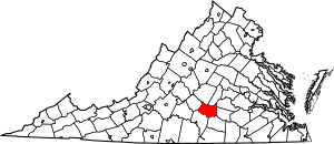
This list shows all the cool historic places right here in Prince Edward County. There are 15 of them, and two are even more special: they are called National Historic Landmarks. This means they are extra important to the whole country's history! You can even see where these places are on a map if you look up their coordinates.
Discovering Prince Edward County's Historic Treasures
| Name on the Register | Image | Date listed | Location | City or town | Description | |
|---|---|---|---|---|---|---|
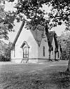
| 1 | Briery Church |
(#69000371) |
Northwest of the junction of U.S. Route 15 and Briery Rd. 37°05′23″N 78°28′44″W / 37.089722°N 78.478889°W |
Briery | Briery Church is a historic Presbyterian church. It was built a long time ago and has been a place of worship for many years. It shows the early history of faith in the area. | |
| 2 | Buffalo Presbyterian Church |
(#95000395) |
Buffalo Church Rd., 0.3 miles (0.48 km) south of its junction with Five Forks Rd. 37°14′27″N 78°36′02″W / 37.240833°N 78.600556°W |
Pamplin | Buffalo Presbyterian Church is another old church in the county. It has a unique design and tells a story about the community's past. | |
| 3 | Debtor's Prison |
(#72001412) |
U.S. Route 15 37°13′41″N 78°26′34″W / 37.228111°N 78.442694°W |
Worsham | Debtor's Prison is a very old building that was once used to hold people who owed money. It's a rare example of this type of building from early American history. | |
| 4 | Falkland |
(#79003071) |
Northwest of Meherrin on Falkland Rd. 37°07′52″N 78°24′30″W / 37.131111°N 78.408333°W |
Redd Shop | Falkland is a historic home that shows how people lived a long time ago. It has special architecture that makes it important. | |
| 5 | Farmville Historic District |
(#89001822) |
Roughly bounded by Main, Venable, High, Ely, and School Sts., 1st Ave., Irving St., 2nd Ave., Oak, W. 3rd, and Mill Sts. 37°18′06″N 78°23′48″W / 37.301667°N 78.396667°W |
Farmville | The Farmville Historic District is a whole area in the town of Farmville. It includes many old buildings and streets that show what the town looked like in the past. | |
| 6 | First Baptist Church |
(#13000046) |
100 S. Main St. 37°18′03″N 78°23′35″W / 37.300833°N 78.393056°W |
Farmville | ||
| 7 | Hampden-Sydney College Historic District |
(#70000822) |
Bounded approximately by the Hampden-Sydney College campus 37°14′34″N 78°27′32″W / 37.242639°N 78.458889°W |
Hampden-Sydney | The Hampden-Sydney College Historic District includes the campus of one of the oldest colleges in the United States. Many of its buildings are very old and have seen a lot of history. | |
| 8 | High Bridge |
(#08000875) |
Appomattox River 37°18′43″N 78°19′10″W / 37.311944°N 78.319444°W |
Farmville | High Bridge is a very long and tall bridge over the Appomattox River. It played an important role during the American Civil War and is now a popular trail for walking and biking. It also extends into Cumberland County. | |
| 9 | Longwood House |
(#84003564) |
Johnson Dr. 37°17′30″N 78°22′46″W / 37.291528°N 78.379583°W |
Farmville | Longwood House is a historic building that is part of Longwood University. It's a beautiful example of old architecture and has been a center for education for many years. | |
| 10 | Robert Russa Moton Boyhood Home |
(#14000149) |
4162 Lockett Rd., about 10 miles (16 km) from Rice 37°19′26″N 78°16′10″W / 37.323806°N 78.269306°W |
Rice | ||
| 11 | Robert Russa Moton High School |
(#95001177) |
Junction of S. Main St. and Griffin Boulevard 37°17′29″N 78°23′52″W / 37.291389°N 78.397778°W |
Farmville | Robert Russa Moton High School is a National Historic Landmark. It was a key place in the fight for equal education for all students. It is now a museum that tells this important story. | |
| 12 | Old Prince Edward County Clerk's Office |
(#79003072) |
U.S. Route 15 37°13′44″N 78°26′32″W / 37.228889°N 78.442222°W |
Worsham | ||
| 13 | Sayler's Creek Battlefield |
(#85002436) |
Sayler's Creek, James Town, and Bunker Hill Rds. 37°19′55″N 78°14′48″W / 37.331944°N 78.246667°W |
Farmville | Sayler's Creek Battlefield is a National Historic Landmark and the site of a major battle during the American Civil War. It was one of the last big battles before the war ended. | |
| 14 | Twin Lakes State Park |
(#12000906) |
788 Twin Lakes Rd. 37°10′26″N 78°16′25″W / 37.173889°N 78.273611°W |
Green Bay | Twin Lakes State Park is a beautiful natural area with two lakes. It offers outdoor fun like camping and swimming, and it also has a history related to how parks were developed in Virginia. | |
| 15 | Worsham High School |
(#10000384) |
8832 Abilene Rd. 37°13′49″N 78°26′47″W / 37.230278°N 78.446389°W |
Farmville | Worsham High School is a former school building that served the community for many years. It represents the history of education in the area. |

All content from Kiddle encyclopedia articles (including the article images and facts) can be freely used under Attribution-ShareAlike license, unless stated otherwise. Cite this article:
National Register of Historic Places listings in Prince Edward County, Virginia Facts for Kids. Kiddle Encyclopedia.


