
National Register of Historic Places listings in Richmond County, Georgia facts for kids
Richmond County, Georgia, is home to many amazing places that are listed on the National Register of Historic Places. This special list includes buildings, areas, and objects that are important to the history of the United States. When a place is on this list, it means it's recognized for its historical or architectural value.
Augusta and Richmond County used to be separate, but they joined together to form Augusta-Richmond. This area has a rich past, and many of its historic sites tell stories about how people lived, worked, and built communities long ago. Let's explore some of these cool places!
Contents
- Historic Buildings and Homes
- Academy of Richmond County
- Augusta Cotton Exchange Building
- Stephen Vincent Benet House
- Brahe House
- Engine Company Number One
- Fruitlands
- Gertrude Herbert Art Institute
- Lamar Building
- Joseph Rucker Lamar Boyhood Home
- Meadow Garden
- Old Medical College Building
- Old Richmond County Courthouse
- Shiloh Orphanage
- Tubman High School
- United States Post Office and Courthouse
- Woodrow Wilson Boyhood Home
- Historic Churches
- Historic Districts
- Augusta Canal Industrial District
- Augusta Downtown Historic District
- Bethlehem Historic District
- Broad Street Historic District
- Greene Street Historic District
- Harrisburg-West End Historic District
- Laney-Walker North Historic District
- Pinched Gut Historic District
- Sands Hill Historic District
- Seclusaval and Windsor Spring
- Summerville Historic District
- Images for kids
Historic Buildings and Homes
Many old buildings and houses in Richmond County have been preserved because they are so important. They show us what life was like in different times.
Academy of Richmond County
The Academy of Richmond County is a very old school. The first building, located at 540 Telfair Street, was listed in 1973. Later, the campus built in 1926, at 910 Russell Street, was also added to the list. It's neat to see how a school can have such a long history!
.jpg)

Augusta Cotton Exchange Building
The Augusta Cotton Exchange Building on Reynolds Street was once a very busy place. It was where people bought and sold cotton, which was a huge part of Augusta's economy a long time ago. This building reminds us of the city's past as a center for trade.

Stephen Vincent Benet House
The Stephen Vincent Benet House at 2500 Walton Way was the home of Stephen Vincent Benét, a famous American writer. His house is so important that it's also a National Historic Landmark, which is an even higher level of historical recognition!
.jpg)
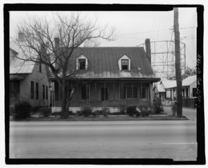
Brahe House
The Brahe House at 456 Telfair Street is another historic home. It was listed in 1973 and is a great example of the architecture from its time.

Engine Company Number One
Located at 452 Ellis Street, Engine Company Number One was an early fire station. It's cool to see how fire departments operated in the past and how their buildings looked.

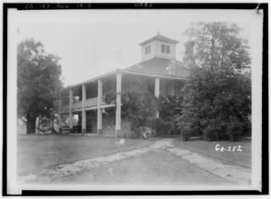
Fruitlands
Fruitlands is a historic home at 2604 Washington Road. It was listed in 1979 and has a unique history.
Gertrude Herbert Art Institute
The Gertrude Herbert Art Institute at 506 Telfair Street is a beautiful building that now serves as an art institute. It was listed in 1973 and helps keep art alive in Augusta.

Lamar Building
The Lamar Building at 753 Broad Street is a tall, impressive building. It was listed in 1979 and stands out in the Augusta skyline.

Joseph Rucker Lamar Boyhood Home
The childhood home of Joseph Rucker Lamar, a Supreme Court Justice, is at 415 7th Street. It's interesting to see where important figures in history grew up.

Meadow Garden
Meadow Garden at 1230 Nelson Street is super important! It was the home of George Walton, who was the youngest person to sign the United States Declaration of Independence. This house is also a National Historic Landmark.

Old Medical College Building
The Old Medical College Building at Telfair and 6th Streets was once a medical school. It's a National Historic Landmark and shows the history of medicine and education in the area.
.jpg)
Old Richmond County Courthouse
The Old Richmond County Courthouse at 432 Telfair Street was where important legal decisions were made. It was listed in 1978 and is a key part of the county's government history.

Shiloh Orphanage
The Shiloh Orphanage at 1635 15th Street provided care for children in the past. It was listed in 1996 and reminds us of the community's efforts to help those in need.

Tubman High School
Tubman High School at 1740 Walton Way was listed in 1994. It's another important school building that has served the community for many years.
.jpg)
United States Post Office and Courthouse
The United States Post Office and Courthouse at 500 E. Ford Street is a grand building that has served as both a post office and a courthouse. It was listed in 2000.
.jpg)
Woodrow Wilson Boyhood Home
The Woodrow Wilson Boyhood Home at 419 7th Street was where Woodrow Wilson, who later became a U.S. President, lived as a boy. This house is also a National Historic Landmark.
.jpg)
Historic Churches
Several churches in Richmond County are also on the National Register, showing their importance to the community's spiritual and architectural history.
First Baptist Church of Augusta
The First Baptist Church of Augusta at Greene and 8th Streets was listed in 1972. It's a significant religious building in the city.

First Presbyterian Church of Augusta
The First Presbyterian Church of Augusta at 642 Telfair Street was listed in 1997. It's another beautiful and historically important church.
.jpg)
Sacred Heart Catholic Church
The Sacred Heart Catholic Church at Greene and 13th Streets is a stunning building. It was listed in 1972 and is now a cultural center, hosting events and activities.

Springfield Baptist Church
Springfield Baptist Church at 112 12th Street is a very important historical site, especially for African American history. It was listed in 1982.

St. Paul's Episcopal Church
St. Paul's Episcopal Church at 6th and Reynolds Streets was listed in 1973. It's another beautiful example of historic church architecture.
,_605_Reynolds_Street,_Augusta_(Richmond_County,_Georgia).jpg)
Historic Districts
Historic districts are areas that contain many historic buildings, showing how neighborhoods and parts of the city developed over time.
Augusta Canal Industrial District
The Augusta Canal Industrial District is a very special area along the Savannah River. It's a National Historic Landmark because the canal and the industries around it were very important for Augusta's growth. It even extends into Columbia County!
.jpg)
Augusta Downtown Historic District
The Augusta Downtown Historic District covers a large part of downtown Augusta, including many streets and buildings. It shows how the city center has changed and grown over the years.
Bethlehem Historic District
The Bethlehem Historic District is a neighborhood roughly bounded by Wrightsboro Road, MLK Jr. Boulevard, and other streets. It's a great example of a historic residential area.

Broad Street Historic District
The Broad Street Historic District includes the main street of Augusta between 5th and 13th Streets. This area has many historic shops and buildings that tell the story of Augusta's commercial past.

Greene Street Historic District
The Greene Street Historic District focuses on Greene Street. This area is known for its beautiful historic homes and buildings.

Harrisburg-West End Historic District
The Harrisburg-West End Historic District is a large area bounded by 15th Street, Walton Way, and the Augusta Canal. It's another important neighborhood that shows the city's development.
.JPG)
Laney-Walker North Historic District
The Laney-Walker North Historic District is a neighborhood with many historic buildings, showing how people lived in this part of Augusta.
Pinched Gut Historic District
The Pinched Gut Historic District has an interesting name! It's a historic neighborhood roughly bounded by Gordon Highway and other streets.

Sands Hill Historic District
The Sands Hill Historic District is another historic neighborhood in Augusta, known for its unique character and historic homes.
.jpg)
Seclusaval and Windsor Spring
Located in Hephzibah, the Seclusaval and Windsor Spring area was once a popular resort. It was listed in 1988 and tells a story of leisure and health in the past.
.JPG)
Summerville Historic District
The Summerville Historic District is a beautiful area roughly bounded by Milledge Lane and other streets. It's known for its lovely historic homes and tree-lined streets.
Images for kids
-
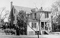
The Harper House, part of the College Hill National Historic Landmark.
-
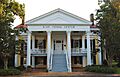
The Reid-Jones-Carpenter House.
.jpg)
.JPG)
