
National Register of Historic Places listings in Rosebud County, Montana facts for kids

This article lists special places in Rosebud County, Montana that are part of the National Register of Historic Places. This is like a national list of important buildings, sites, and objects. These places are recognized for their history, architecture, or what they mean to American culture.
In Rosebud County, there are 21 such places. One of them is even more special. It's called a National Historic Landmark. This means it's one of the most important historic sites in the entire country!
Exploring Rosebud County's Historic Sites
Rosebud County in Montana has many interesting places. These sites help us learn about the past. They show us how people lived and worked long ago.
Historic Buildings in Forsyth
Many historic buildings are found in Forsyth, Montana. This city is the county seat of Rosebud County.
Homes and Meeting Places
- The Herman and Hannah Anderson House is a historic home. It was built a long time ago.
- The Blue Front Rooming House is another old building. It used to offer rooms for people to stay.
- The Brotherhood of Locomotive Engineers Hall was a meeting place. Train workers would gather there.
- The Claude O. Marcyes House is also a historic home. It shows us how houses looked in the past.
- The Cold Springs Ranch House is a ranch home. It is located west of Forsyth.
Important Public Buildings
- The First Presbyterian Church and Manse is a beautiful old church. The manse is where the minister lived.
- The Rosebud County Courthouse is a very important building. It's where county government happens. It was built in 1986.
- The Rosebud County Deaconess Hospital was an early hospital. It helped people get well.
- The Howard School is an old school building. It taught children many years ago.
- The Forsyth Water Pumping Station helped bring water to the town. It was a key part of the city's growth.
Forsyth's Historic Districts
- The Forsyth Main Street Historic District includes many old shops and buildings. They line the main street.
- The Forsyth Residential Historic District has many historic homes. These homes show different styles of building.
Historic Places in Other Towns
Rosebud County has historic sites beyond Forsyth too.
Ingomar's Old Buildings
- The J.A. Bookman General Store was a general store. People could buy many things there.
- The Ingomar Public School is an old school building. It served the community of Ingomar, Montana.
- The Wiley, Clark & Greening Bank was a bank. It helped people with their money.
Ranches and Churches
- The Bones Brothers Ranch is a large historic ranch. It is located near Birney, Montana.
- St. Philip's Episcopal Church is a historic church. It is located in the town of Rosebud, Montana.
Vananda Historic District
- The Vananda Historic District is a historic area. It is located west of Forsyth. It shows what a small town looked like.
National Historic Landmarks
Two sites in Rosebud County are extra special. They are National Historic Landmarks.
Deer Medicine Rocks
- Deer Medicine Rocks is a very important site. It is located near Lame Deer, Montana. This place has special rock carvings. It is a sacred site for Native American tribes.
Wolf Mountains Battlefield
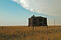
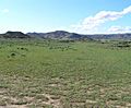
- The Wolf Mountains Battlefield is another landmark. It is also known as "Where Big Crow walked Back and Forth." This site near Birney, Montana was a battlefield. A famous battle took place here. It was part of the Great Sioux War.
Images for kids
-
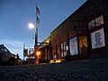
The J.A. Bookman General Store in Ingomar.
-
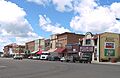
Main Street in Forsyth.
-
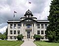
The Rosebud County Courthouse.
-
Buildings in the Vananda Historic District.
-
The Wolf Mountains Battlefield.


