
National Register of Historic Places listings in Seminole County, Florida facts for kids

This article is about special places in Seminole County, Florida, United States. These places are listed on the National Register of Historic Places. Think of it like a very important list of old buildings, areas, or sites that are super special because of their history or how they look. The government wants to help protect these places so everyone can learn from them.
There are 18 different buildings and areas in Seminole County that are on this important list. Each one has a unique story to tell about the past!
Contents
What is the National Register of Historic Places?
The National Register of Historic Places is the official list of the nation's historic places. It is part of a program by the United States government. This program helps to identify and protect historic and archaeological sites. When a place is added to this list, it means it is important to the history of the local area, the state, or even the whole country.
Being on the list encourages people to preserve these places. It also helps people learn about the past. These places can be old houses, churches, schools, or even whole neighborhoods. They tell us about how people lived, worked, and built things a long time ago.
Historic Treasures in Seminole County
Seminole County has many interesting places on the National Register. These sites show different parts of the county's history. Let's explore some of them.
Homes with History
Many old houses in Seminole County are on the list. These homes often have unique architecture or belonged to important people.
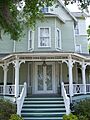
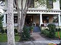
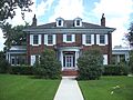
Bradlee-McIntyre House
The Bradlee-McIntyre House is in Longwood. It was added to the list in 1991. This house is a beautiful example of old Florida homes. It shows how people built houses many years ago.
Browne-King House
In Oviedo, you can find the Browne-King House. This house became a historic place in 2001. It is another example of a well-preserved old home in the county.
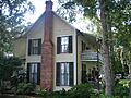
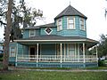
Wheeler-Evans House
Also in Oviedo, the Wheeler-Evans House joined the list in 2001. These old homes help us imagine what life was like in Seminole County long ago.
Important Community Buildings
Some buildings on the list were once important gathering spots or served the community in special ways.
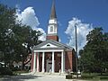
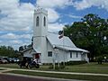
First Methodist Church of Oviedo
The First Methodist Church of Oviedo was added to the list in 2007. Churches are often important historical sites. They show how communities grew and how people practiced their faith.
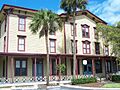
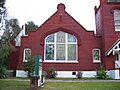
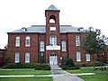
Hopper Academy
Hopper Academy is in Sanford. It became a historic place in 2015. This building was likely an important school. It tells us about education in the past.
Lake Mary Chamber of Commerce Building
The Lake Mary Chamber of Commerce Building in Lake Mary was listed in 2004. This building probably played a role in the business and growth of Lake Mary.
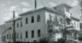
Old Fernald-Laughton Memorial Hospital
In Sanford, the Old Fernald-Laughton Memorial Hospital was added in 1987. Hospitals are key parts of a community's history. They show how healthcare has changed over time.
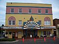
Wayne Densch Performing Arts Center (Ritz Theater)
The Wayne Densch Performing Arts Center, also known as the Ritz Theater, is in Sanford. It was listed in 2001. This theater was a place where people went for entertainment. It reminds us of how people spent their free time.
St. James A. M. E. Church
The St. James A. M. E. Church in Sanford joined the list in 1992. This church is an important part of the community's history. It represents the strength and spirit of its members.
Sanford Grammar School
The Sanford Grammar School was listed in 1984. Schools are very important in any community. This old school building shows us how children were educated many years ago.
Seminole County Home
The Seminole County Home in Sanford was added in 1999. This building likely served as a place for people who needed care or support. It tells a story about community welfare.
Historic Districts: Whole Neighborhoods with Stories
Sometimes, not just one building, but a whole area is considered historic. These are called "historic districts." They are special because many buildings in the area together tell a story.
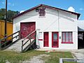
R. W. Estes Celery Company Precooler Historic District
The R. W. Estes Celery Company Precooler Historic District is in Oviedo. It was listed in 2001. This district tells us about farming and how food was processed in the past. Oviedo was once famous for its celery!
Longwood Historic District
The Longwood Historic District in Longwood was added in 1990. This district includes many old buildings. Together, they show what Longwood looked like a long time ago.
Nelson and Company Historic District
Another district in Oviedo is the Nelson and Company Historic District, listed in 2001. This area might have been important for businesses or industries in Oviedo's past.
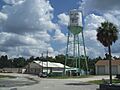
Sanford Commercial District
The Sanford Commercial District was listed in 1976. This district includes parts of old downtown Sanford. It shows where businesses and shops were located many years ago.
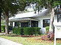
Sanford Residential Historic District
The Sanford Residential Historic District was added in 1989. This district includes many old homes. It gives us a picture of how neighborhoods looked and felt in Sanford's history.
Why These Places Matter
These historic places in Seminole County are like open books. They help us understand the past. They show us how people lived, worked, and built their communities. By protecting these sites, we make sure that future generations can also learn from them. It's like keeping a piece of history alive for everyone to see and enjoy!
Images for kids
-
The Bradlee-McIntyre House in Longwood.
-
The Browne-King House in Oviedo.
-
A building in the R. W. Estes Celery Company Precooler Historic District.
-
The First Methodist Church of Oviedo.
-
Hopper Academy in Sanford.
-
The Lake Mary Chamber of Commerce Building.
-
A church within the Longwood Historic District.
-
The Longwood Hotel.
-
A building in the Nelson and Company Historic District.
-
The Old Fernald-Laughton Memorial Hospital in Sanford.
-
The Wayne Densch Performing Arts Center, also known as the Ritz Theater.
-
St. James A. M. E. Church in Sanford.
-
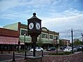
A clock tower in the Sanford Commercial District.
-
The Sanford Grammar School.
-
A house in the Sanford Residential Historic District.
-
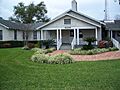
The Seminole County Home.
-
The Wheeler-Evans House in Oviedo.


