
National Register of Historic Places listings in Smithtown (town), New York facts for kids
The Town of Smithtown is a place with a rich history, and many of its important buildings and areas are protected! These special spots are listed on the National Register of Historic Places. Think of it like a national honor roll for buildings, parks, and neighborhoods that are super important to America's past. When a place is on this list, it means it's recognized for its history, architecture, or what happened there. This helps make sure these places are preserved for future generations, so kids like you can learn about them too!
Contents
What is the National Register of Historic Places?
The National Register of Historic Places is the official list of the United States' historic places worth saving. It's managed by the National Park Service. Being on this list helps protect these places and sometimes even helps get money to fix them up. It's all about celebrating and keeping alive the stories of our country.
Historic Places in Smithtown
Smithtown has many cool places on the National Register. These include old homes, churches, and even whole neighborhoods that tell us about life long ago. Let's explore some of them!
Homes with History
Many of the places on the list are beautiful old homes. These houses often have unique designs and stories.
Beachbend
Located in Nissequogue, Beachbend was added to the list in 1993. It's a private home, but it's recognized for its special history and architecture.
By-the-Harbor
Also in Nissequogue, By-the-Harbor joined the list in 1993. It's another example of the beautiful historic homes found in the area.
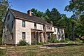
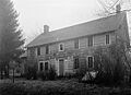
East Farm
You can find East Farm in Head of the Harbor. This historic farm was added in 1993 and gives us a peek into the agricultural past of the region.

Harbor House
Another Nissequogue gem, Harbor House, was listed in 1993. It's part of the collection of important homes in the area.
Land of Clover
This interesting name belongs to another historic property in Nissequogue, listed in 1993.
The Mallows
In Head of the Harbor, The Mallows was recognized in 1993. It's a significant historic home.
James W. and Anne Smith Phyfe Estate
This estate in Nissequogue was added in 1993, showing the importance of family estates in the area's history.
Rassapeague
Another Nissequogue property, Rassapeague, was listed in 1993.
William J. Ryan Estate
The William J. Ryan Estate in Nissequogue also made the list in 1993.
Shore Cottage
In Head of the Harbor, Shore Cottage was added in 1993.
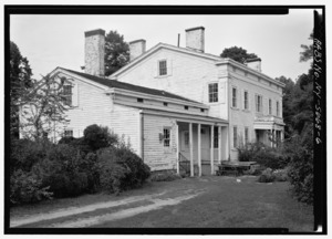
Obadiah Smith House
The Obadiah Smith House in Kings Park is a very old and important house, listed in 1996. It's a great example of early American architecture.
.jpg)
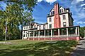
Kate Annette Wetherill Estate
This estate in Head of the Harbor was listed in 1993. It's known for its unique design.

Woodcrest
Woodcrest, located in Nissequogue, was added to the list in 1993.
Historic Districts and Parks
Sometimes, it's not just one building that's historic, but a whole area or park! These are called historic districts.
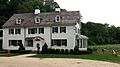
Blydenburgh Park Historic District
Blydenburgh County Park in Smithtown is home to a historic district that was listed in 1983. This park has old buildings and beautiful nature, making it a special place.

Box Hill Estate
Northwest of St. James, the Box Hill Estate was recognized as a historic district in 1973.
Mills Pond District
East of St. James, the Mills Pond District was listed in 1973. This area along NY 25A has a lot of history.
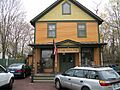
Saint James District
The Saint James District, located on NY 25A in Saint James, was added to the list in 1973. This district includes many historic buildings that give the area its unique charm.

Village of the Branch Historic District
Along the north side of Middle Country Road in Branch, this historic district was listed in 1986. It helps preserve the historic feel of the village.
Wyandanch Club Historic District
The Wyandanch Club Historic District is located southwest of Jericho Turnpike in Smithtown. It was added to the list in 1990.

Other Important Structures
Not all historic places are homes or districts. Some are important public buildings or sites.
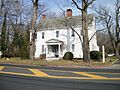
First Presbyterian Church
The First Presbyterian Church in Branch is a beautiful and historic church, listed in 1977. Churches often play a big role in a community's history.

Fort Salonga
The site of Fort Salonga in Fort Salonga was added to the list in 1982. This location has historical significance, even if its exact address is kept private for protection.
Halliock Inn
The Halliock Inn, located in Branch, was listed in 1974. Inns were important places for travelers and community gatherings in the past.

Images for kids
-
The Weld Farmhouse inside Blydenburgh Park.
-
The historic farmhouse at East Farm.
-
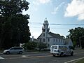
The First Presbyterian Church in Smithtown.
-
The historic Halliock Inn.
-

The Mills Pond House, part of the historic district.
-
The Obadiah Smith House, a historic landmark.
-
The Saint James General Store, a historic building in the district.
-

An aerial view of the Kate Annette Wetherill Estate.
-
The historic Wyandanch Club.
