
National Register of Historic Places listings in Solano County, California facts for kids

Have you ever wondered about old buildings or places that have a special story? In Solano County, California, there are many such places! They are so important that they are listed on something called the National Register of Historic Places. This is like a special list kept by the United States government to protect and celebrate buildings, sites, and objects that are important to American history, architecture, archaeology, engineering, or culture.
When a place is on this list, it means it's recognized for its unique value and history. There are 31 places in Solano County on this list, and one of them is even a National Historic Landmark, which is an even higher level of importance! Let's explore some of these amazing historic spots.
Contents
Historic Places in Solano County
Benicia's Historic Treasures

The city of Benicia has several cool historic sites. One of the most interesting is the Benicia Arsenal. This was once a huge military base where weapons and supplies were stored. It was active for over 100 years, from 1851 to 1964! A very unique part of its history involves camels! Yes, camels were brought here in the 1850s to be used for transportation in the desert. You can still see the old "Camel Barn" today. The Benicia Arsenal was added to the National Register in 1976.
Another important place in Benicia is the Benicia Capitol State Historic Park. Did you know that Benicia was once the capital of California? For a short time in the 1850s, this building was where the state government met. It's a beautiful old building that helps us remember an important part of California's early days. It became a historic place in 1971.

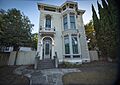
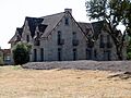
Benicia also has some beautiful old homes and buildings. The Carr House, built in 1879, was a lovely home, though it was sadly taken down around the year 2000. The Crooks Mansion, built in 1860, is another grand old house that shows us what homes looked like long ago. It was listed in 1978. The Joseph Fischer House, from 1850, is one of the oldest homes in Benicia and was added to the list in 1979.
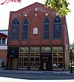
Even the Old Masonic Hall in Benicia, built in 1850, is on the list. Masonic halls are meeting places for a social organization called the Freemasons. This one is special because it's one of the oldest in California. It was recognized in 1972.
_1945.jpg)
Vallejo is home to a very important historic site: the Mare Island Naval Shipyard. This was the first permanent U.S. naval base on the Pacific Ocean, opening in 1854! For many years, ships were built, repaired, and stored here. It played a huge role in many wars, especially World War II. It's so important that it's a National Historic Landmark, listed in 1975.
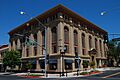
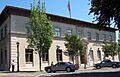
Vallejo also has several historic buildings that show how the city grew. The City Hall building, built in 1927, is a grand building that has served as the center of city government for many years. It was added to the list in 2013. Another important building is the Masonic Temple-Naval Lodge No. 87, built in 1917, which also served as a meeting place for the Freemasons. It was listed in 2013.

The Vallejo Old City Historic District is a whole area of the city, not just one building, that is considered historic. This district includes many old homes and buildings that show what Vallejo looked like in its early days. It was recognized in 1973.
Vacaville and Dixon's Early Days

In Vacaville, you can find the Pena Adobe. This is one of the oldest buildings in Solano County, built way back in 1842! It's an "adobe" building, meaning it was made from sun-dried mud bricks. It was home to the Pena family, who were early settlers in the area. It became a historic site in 1972.
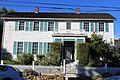
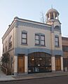
The Will H. Buck House in Vacaville, built in 1892, is another beautiful old home on the list. It shows the fancy architectural styles of that time. It was listed in 1985. The Vacaville Town Hall, built in 1907, was once the center of local government and is now also a historic landmark, recognized in 1978.

In Dixon, the Dixon Carnegie Library is a special building. Many towns across the U.S. have "Carnegie Libraries" because a very rich man named Andrew Carnegie helped fund their construction so that everyone could have access to books. This library was built in 1912 and became a historic place in 2011.
Other Interesting Solano County Sites

The Bird and Dinkelspiel Store in Birds Landing is a general store built in 1875. Imagine a time when this store was the main place for people to buy everything they needed! It was listed in 1999.
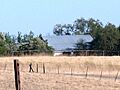
The Hastings Adobe near Collinsville, built in 1846, is another example of an early adobe home in the county. It was recognized in 1972.

For train lovers, the Sacramento Northern Railway Historic District in Suisun City is a must-see. This district includes parts of an old electric railway that used to connect cities in Northern California. Today, it's home to the Western Railway Museum, where you can see and even ride historic trains! It was added to the list in 2012.
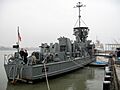
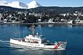
The USCGC STORIS (cutter) is a ship that was once part of the U.S. Coast Guard. It's a very old ship, built in 1942, and served in many important missions, including in the Arctic. It was listed as a historic place in 2012 and is located in Suisun Bay.
These are just some of the many historic places in Solano County that help us understand the past and appreciate the stories of the people who lived there long ago.
Images for kids
-
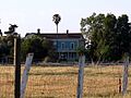
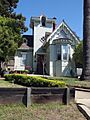
The Jackson Fay Brown House in Dixon.
-
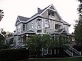
The Will H. Buck House in Vacaville.
-
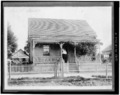
The Carr House in Benicia, before it was demolished.
-
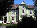
The Crooks Mansion in Benicia.
-
The Joseph Fischer House in Benicia.
-
The Daniel Webster Harrier House in Vallejo.
-
The Hastings Adobe near Collinsville.
-
The LCS-102 (landing craft support) ship.
-
The Samuel Martin House in Suisun City.
-
The Masonic Temple in Vallejo.
-
The Old Masonic Hall in Benicia.
-
A building within the Saint Vincent's Hill Historic District in Vallejo.
-
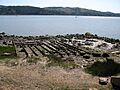
The location where the whaling bark STAMBOUL was once moored.
-
The Suisun Masonic Lodge No. 55.
-
The USCGC STORIS (cutter) ship.
-
The Vacaville Town Hall.
-
The Vallejo City Hall and County Building Branch.
-
A building in the Vallejo Old City Historic District.
-
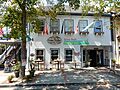
The Von Pfister General Store in Benicia.


_102.jpg)


