
National Register of Historic Places listings in St. John the Baptist Parish, Louisiana facts for kids

Have you ever wondered about really old buildings and places that are super important to history? In St. John the Baptist Parish, Louisiana, there are many such special spots! This article will tell you about some of these amazing places. They are all listed on the National Register of Historic Places. This is like a special list kept by the United States government. It helps protect places that are important for their history, architecture, or what they mean to our country.
There are 17 places in this parish that are on the National Register. Two of these are even more special. They are called National Historic Landmarks. This means they are considered important to the history of the entire country!
Contents
Exploring Historic Places in St. John the Baptist Parish
St. John the Baptist Parish is full of history. Many of its historic places are old homes and plantations. These buildings tell stories about how people lived long ago. Let's take a closer look at some of these fascinating sites.
Evergreen Plantation: A National Treasure

One of the most important places in the parish is Evergreen Plantation. It's located near Wallace. This plantation is a National Historic Landmark. This means it's super important to the history of the whole United States!
Evergreen Plantation is special because it has 37 buildings. This includes a main house and 22 old slave cabins. These cabins show what life was like for enslaved people before the American Civil War. The plantation is a great example of the large farms that were common in the Southern United States a long time ago. You can even visit Evergreen Plantation today to learn about its history.
San Francisco Plantation: A Unique Home

Another amazing National Historic Landmark in the parish is the San Francisco Plantation House. You can find it near Reserve. This house was built in 1856. It has a very unique style that looks a bit like a steamboat. It's known for its fancy decorations and bright colors. The plantation was named after the first owner's steamboat, "San Francisco." This house is also open for visitors to explore.
Historic Homes and Stores
Many other buildings in the parish are also on the National Register. They might not be National Historic Landmarks, but they are still very important to the local history.
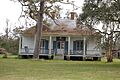
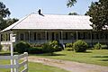
Bacas House
The Bacas House is an old home located east of Evergreen Plantation in Edgard. It was added to the National Register in 1990. This house shows the style of homes built in the area a long time ago.
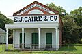
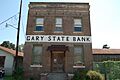
E.J. Caire & Co. Store
In Edgard, you can find the E.J. Caire & Co. Store. This store was started by Jean Baptiste Caire. It was run for many years by Etienne J. Caire. The store finally closed in the mid-1970s. It's a great example of an old general store.
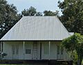
Dugas House
The Dugas House is another historic home in Edgard. It was listed in 1989. Like many homes in the area, it shows the traditional architecture of Louisiana.
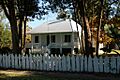
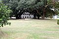
Emilie Plantation House
Near Garyville, you'll find the Emilie Plantation House. This house was added to the list in 1989. It's another example of the beautiful plantation homes in the region.
Godchaux-Reserve Plantation House
The Godchaux-Reserve Plantation House is located in Reserve. It became a historic place in 1994. This house has a rich history connected to the sugar cane industry in Louisiana.
Graugnard House
Also in Reserve is the Graugnard House. It was listed in 1994. This home adds to the collection of historic buildings that tell the story of the parish.
Haydel-Jones House
The Haydel-Jones House is on River Road in Edgard. It was added to the National Register in 2010. This house is a good example of French Creole architecture in Louisiana.
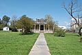
Hope Plantation House
In Garyville, the Hope Plantation House was listed in 2005. It's another important piece of the area's history.
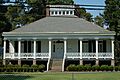
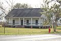
Montegut Plantation House
The Montegut Plantation House is in LaPlace. It was added to the list in 1988. This house shows the architectural styles popular in the late 1800s.
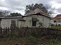
Sorapuru House
The Sorapuru House is another historic home in Edgard. It was listed in 1999.
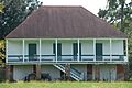
Woodland Plantation
The Woodland Plantation in LaPlace was added to the National Register in 2017. It is one of the more recently listed historic places in the parish.
Historic Districts
Sometimes, not just one building is important, but a whole group of buildings or an area. These are called historic districts.
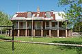
Garyville Historic District
The Garyville Historic District is a special area in Garyville. It was listed in 1990. This district includes many buildings that show what Garyville was like in the past. It's a great place to see how a whole town developed.
Whitney Plantation Historic District
The Whitney Plantation Historic District is located east of Wallace. It was listed in 1992. This district is important because it focuses on the history of slavery. It has many original slave cabins and buildings that tell the story of the enslaved people who lived and worked there. It is a museum dedicated to understanding this difficult part of history.
Other Important Sites
Bayou Jasmine Archeological Site
The Bayou Jasmine Archeological Site near LaPlace is a very old place. It was listed in 1976. This site is important for studying how people lived in the area thousands of years ago. Its exact location is kept secret to protect it.
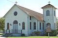
Our Lady of Grace Church
The Our Lady of Grace Church in Reserve was added to the National Register in 2005. This church is important to the community's history and faith.
These historic places in St. John the Baptist Parish help us remember the past. They teach us about different times and how people lived. Visiting them is like taking a step back in time!
Images for kids
-
Bacas House
-
E.J. Caire & Co. Store
-
Dugas House
-
Emilie Plantation House
-
Garyville Historic District
-
Godchaux-Reserve Plantation House
-
Graugnard House
-
Haydel-Jones House
-
Hope Plantation House
-
Montegut Plantation House
-
Our Lady of Grace Church
-
Sorapuru House
-
Whitney Plantation Historic District
-
Woodland Plantation


