
National Register of Historic Places listings in Stanislaus County, California facts for kids

Have you ever wondered about the oldest and most special buildings or places in your area? In Stanislaus County, California, there's a list of amazing historic spots! These places are so important that they are officially recognized on the National Register of Historic Places. This list helps protect them so future generations can enjoy them too.
There are 24 different properties and areas in Stanislaus County that are on this special list. One of them is even a National Historic Landmark, which means it's super important to the history of the entire United States!
Contents
What is the National Register of Historic Places?
The National Register of Historic Places is like a hall of fame for historic buildings, sites, and objects in the United States. It's managed by the National Park Service. When a place is added to this list, it means it has a unique history. It might be important for its architecture, its connection to famous people, or its role in big events. Being on the list helps protect these places and can even offer support for their care.
Exploring Stanislaus County's Historic Treasures
Stanislaus County is full of interesting history, from old ranches to grand buildings and even a gold dredge! Let's take a look at some of the cool places on the National Register here.
Historic Buildings in Modesto
Modesto is the biggest city in Stanislaus County and has several historic buildings.
McHenry Mansion: A Glimpse into the Past
The McHenry Mansion is a stunning old house built in 1883. It looks like something out of a storybook! This mansion was once home to Robert McHenry, a very important person in Modesto's early days. Today, it's a museum where you can step back in time and see how people lived over a hundred years ago. It's located at 906 15th Street.
Hotel Covell: A Downtown Landmark
The Hotel Covell at 1023 J Street is another historic building in Modesto. It was built in 1912 and has been a part of the city's downtown area for a long time. Imagine all the travelers and stories this hotel could tell!
El Viejo Post Office: A Place for Letters
The U.S. Post Office building in Modesto, sometimes called the El Viejo Post Office, is found at Twelfth and I Streets. Built in 1933, it's a great example of the kind of grand buildings constructed during that time. It reminds us of a time when sending letters was the main way to communicate.
Historic Sites in La Grange
La Grange is a smaller town with a rich history, especially from the Gold Rush era. Many of its historic buildings are grouped together.
Kingen Hotel and Louie's Place
The Kingen Hotel and Louie's Place are two historic buildings located very close to each other on Yosemite Boulevard in La Grange. They were both added to the National Register in 1979. These buildings give us a peek into what life was like in a busy Gold Rush town.
Old Adobe Barn and Stage Stop
Imagine a time when people traveled by horse and buggy! The Old Adobe Barn and the Stage Stop on Yosemite Boulevard and La Grange Road were important places for travelers. The Stage Stop was where stagecoaches would stop for a break, and the barn likely housed horses. They were both listed in 1979.
Old La Grange Schoolhouse and St. Louis Catholic Church
The Old La Grange Schoolhouse and St. Louis Catholic Church are both located on La Grange Road and Floto Street. The schoolhouse, listed in 1979, taught generations of children. The church, also listed in 1979, has been a place of worship for the community for many years.
Knights Ferry: A National Historic Landmark
Knights Ferry is home to one of Stanislaus County's most important historic sites.
Knights Ferry Bridge: A True Landmark
The Knights Ferry Bridge is not just any bridge; it's a National Historic Landmark! This means it's recognized as being super important to the history of the entire United States. It's a covered bridge that spans the Stanislaus River. Covered bridges are rare and beautiful, and this one has been around since 1862. It's a fantastic example of old engineering and a reminder of how people used to cross rivers. The whole area of Knights Ferry is also a historic district.
Libraries and Schools with History
Several libraries and school buildings in Stanislaus County are also on the National Register, showing their importance to education and community life.
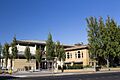
Carnegie Libraries: Gifts for Learning
You might notice a few "Carnegie Libraries" on the list, like the Patterson Branch Library (1990), the Riverbank Branch Library (1996), and the Turlock Carnegie Library (1993). These libraries were built with money donated by Andrew Carnegie, a famous businessman who believed in the power of public libraries. They were designed to be beautiful and welcoming places for everyone to learn.
Turlock High School Auditorium
The Turlock High School Auditorium and Gymnasium is another important building, listed in 1991. Located at 1574 E. Canal Drive, this building has been a central part of the school and community for many years, hosting plays, concerts, and sports events.
Other Notable Historic Places
Stanislaus County's historic places include a variety of interesting sites.
First National Bank of Oakdale Building
The First National Bank of Oakdale Building in Oakdale (listed in 2000) is a great example of early 20th-century bank architecture. It shows how important banks were to the growth of towns.
Gold Dredge: A Relic of the Gold Rush
Imagine a giant machine that dug for gold! The Gold Dredge south of La Grange (listed in 1971) is a reminder of the California Gold Rush. These massive machines were used to dig up riverbeds to find gold, changing the landscape in big ways.
Daniel Whitmore House: A Ceres Gem
The Daniel Whitmore House in Ceres (listed in 1989) is a historic home that tells the story of early settlers in the area. It's located at 2928 Fifth Street.
Current listings
| Name on the Register | Image | Date listed | Location | City or town | Description | |
|---|---|---|---|---|---|---|
| 1 | Bald Eagle Ranch House |
(#13001069) |
511 Crawford Rd. 37°43′08″N 120°59′15″W / 37.718857°N 120.987486°W |
Modesto | ||
| 2 | First National Bank of Oakdale Building |
 |
(#00000320) |
338 East F St. 37°46′01″N 120°50′48″W / 37.766944°N 120.846667°W |
Oakdale | |
| 3 | Gold Dredge |
(#71000208) |
S of La Grange 37°38′00″N 120°28′35″W / 37.633333°N 120.476389°W |
La Grange | ||
| 4 | Hotel Covell |
(#94001501) |
1023 J St. 37°38′28″N 120°59′58″W / 37.641111°N 120.999444°W |
Modesto | ||
| 5 | Kingen Hotel |
 |
(#79003465) |
30054 Yosemite Blvd. 37°39′49″N 120°27′37″W / 37.663611°N 120.460278°W |
La Grange | |
| 6 | Knights Ferry |
 |
(#75000490) |
On the Stanislaus River, 2 miles (3.2 km) from Stanislaus 37°49′11″N 120°39′52″W / 37.819722°N 120.664444°W |
Knights Ferry | |
| 7 | Knight's Ferry Bridge |
 |
(#12001014) |
Spanning Stanislaus River at bypassed section of Sonora Rd., approximately .75 miles (1.21 km) north of CA 108/120 37°39′48″N 120°27′44″W / 37.663333°N 120.462222°W |
Knights Ferry | |
| 8 | Louie's Place |
 |
(#79003466) |
30048 Yosemite Blvd. 37°39′48″N 120°27′44″W / 37.663333°N 120.462222°W |
La Grange | |
| 9 | McHenry Mansion |
 |
(#78000805) |
906 15th St. 37°38′37″N 120°59′37″W / 37.643611°N 120.993611°W |
Modesto | |
| 10 | Odd Fellows Hall |
 |
(#79003467) |
Yosemite Blvd. 37°39′48″N 120°27′41″W / 37.663333°N 120.461389°W |
La Grange | |
| 11 | Old Adobe Barn |
 |
(#79003462) |
Yosemite Blvd. and La Grange Rd. 37°39′50″N 120°27′34″W / 37.663889°N 120.459444°W |
La Grange | |
| 12 | Old La Grange Schoolhouse |
 |
(#79003461) |
La Grange Rd. and Floto St. 37°39′44″N 120°27′35″W / 37.662222°N 120.459722°W |
La Grange | |
| 13 | Patterson Branch Library |
 |
(#90001812) |
355 W. Las Palmas Ave. 37°28′16″N 121°08′31″W / 37.471111°N 121.141944°W |
Patterson | |
| 14 | Plaza Building |
 |
(#03001359) |
Plaza #2 37°28′17″N 121°07′44″W / 37.471389°N 121.128889°W |
Patterson | |
| 15 | Riverbank Branch Library |
 |
(#96001077) |
3237 Santa Fe St. 37°44′11″N 120°56′05″W / 37.736389°N 120.934722°W |
Riverbank | |
| 16 | Shell Gas Station |
 |
(#79003464) |
Yosemite Blvd. 37°39′50″N 120°27′41″W / 37.663889°N 120.461389°W |
La Grange | |
| 17 | St. Louis Catholic Church |
 |
(#79003460) |
La Grange Rd. and Floto St. 37°39′46″N 120°27′39″W / 37.662778°N 120.460833°W |
La Grange | |
| 18 | Stage Stop |
 |
(#79003463) |
Yosemite Blvd. and La Grange Rd. 37°39′49″N 120°27′35″W / 37.663611°N 120.459722°W |
La Grange | |
| 19 | Turlock Carnegie Library |
 |
(#92001753) |
250 N. Broadway 37°29′43″N 120°50′57″W / 37.495278°N 120.849167°W |
Turlock | |
| 20 | Turlock High School Auditorium and Gymnasium |
 |
(#90002141) |
1574 E. Canal Dr. 37°29′54″N 120°49′52″W / 37.498333°N 120.831111°W |
Turlock | |
| 21 | U.S. Post Office |
 |
(#83001246) |
Twelfth and I Sts. 37°38′28″N 120°59′48″W / 37.641111°N 120.996667°W |
Modesto | |
| 22 | Dr. Robert and Mary Walton House |
(#06001133) |
417 Hogue Dr. 37°44′55″N 120°59′36″W / 37.748611°N 120.993333°W |
Modesto | ||
| 23 | Daniel Whitmore House |
 |
(#89000230) |
2928 Fifth St. 37°35′28″N 120°57′03″W / 37.591111°N 120.950833°W |
Ceres | |
| 24 | Walter B. Wood House |
 |
(#88000551) |
814 Twelfth St. 37°38′27″N 120°59′44″W / 37.640833°N 120.995556°W |
Modesto |
Images for kids
-
Another view of the Turlock Carnegie Library.
-
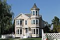
The Walter B. Wood House in Modesto.

