
National Register of Historic Places listings in Stewart County, Georgia facts for kids
Stewart County, Georgia, is home to many special places that are listed on the National Register of Historic Places. This list includes buildings, historic areas, and even old archaeological sites. These places are important because they tell us about the history of the county and the people who lived there long ago.
Contents
What is the National Register of Historic Places?
The National Register of Historic Places (NRHP) is the official list of places in the United States that are worth saving. These places can be buildings, structures, objects, sites, or even entire historic districts. They are chosen because they have special meaning in American history, architecture, archaeology, engineering, or culture.
When a place is added to the NRHP, it means it is recognized as important. This helps to protect it and makes people more aware of its value. It can also help property owners get grants or tax breaks to help preserve these historic spots.
Historic Places in Stewart County
Stewart County has many places listed on the National Register. These sites help us understand the past of this part of Georgia. They include old homes, churches, courthouses, and even places where ancient people once lived.
Notable Homes and Buildings
Many old houses in Stewart County are on the list. These homes show us how people lived and built things in the past.
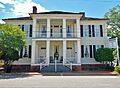
Bedingfield Inn
The Bedingfield Inn in Lumpkin was built around 1836. It's a great example of an old inn where travelers might have stayed. Imagine people arriving by horse and buggy!
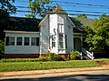
Dr. Thomas B. Miller House
In Richland, you can find the Dr. Thomas B. Miller House. This house, located at 97 Nicholson Street, was added to the Register in 1988. It shows us the kind of homes important people like doctors lived in during earlier times.
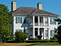
Nathaniel Prothro Plantation
The Nathaniel Prothro Plantation near Richland is another historic site. It was listed in 1985. Plantations like this played a big role in the history and economy of the South.
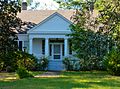
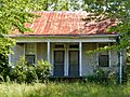
Travis Usher House
The Travis Usher House on Florence Street in Lumpkin was also built around 1836. It is another example of the early architecture in the area.
Important Public and Community Sites
Beyond homes, Stewart County also has important public buildings and community gathering spots on the list.
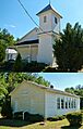
Green Grove Church, School, and Cemetery
The Green Grove Church, School, and Cemetery is a special place. It includes a church, a school, and a cemetery all together. This site shows how important these places were for a community's life, learning, and remembrance. It is located on Old Lumpkin-Eufaula Road.
Old Chattahoochee County Courthouse
The Old Chattahoochee County Courthouse is very unique. It is one of only three courthouses from before the American Civil War that still exist in Georgia. It was originally in Westville and later moved. Courthouses were central to law and order in early towns.
Stewart County Courthouse
The Stewart County Courthouse in Lumpkin is another significant building. It stands on Courthouse Square and has been a center for county government for a long time.
Historic Districts
Some listings are not just single buildings but entire areas called "historic districts." These districts have many buildings that together create a sense of a past time.
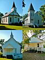
Louvale Church Row Historic District
The Louvale Church Row Historic District in Louvale is a great example. It includes several churches along US 27. This shows how important churches were to the community's social life.
Richland Historic District
The Richland Historic District covers a larger area in Richland. It includes many historic buildings, showing what a town looked like in earlier days. The old Richland Depot, which is now the City Hall, is part of this district.
Archaeological Sites
Stewart County also has very old sites that tell us about people who lived here thousands of years ago. These are called archaeological sites.
Roods Landing Site
The Roods Landing Site is south of Omaha. It is located where Rood Creek meets the Chattahoochee River. This site helps archaeologists learn about ancient cultures that lived along the river.
Singer-Moye Archeological Site
The Singer-Moye Archeological Site is another important place for understanding ancient history. These sites are often kept secret to protect them from damage.
Other Historic Places
Many other individual homes and districts in Stewart County are also listed. These include:
- Armstrong House
- Bush-Usher House
- Dr. Miller's Office
- East Main Street Residential Historic District
- Dr. R. L. Grier House
- George Y. Harrell House
- Jared Irwin House
- Lumpkin Commercial Historic District
- Mathis House
- Pigtail Alley Historic District
- Stoddard Rockwell House
- Second Methodist Church
- Smith-Alston House
- John A. Tucker House
- Uptown Residential Historic District
- West Hill
Each of these places adds to the rich history of Stewart County and helps us remember the past.
Images for kids
-
The historic Bedingfield Inn in Lumpkin.
-
The Green Grove Church and Schoolhouse.
-
Churches in the Louvale Church Row Historic District.
-
The Dr. Thomas B. Miller House in Richland.
-
The Nathaniel Prothro Plantation.
-
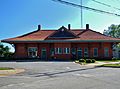
The Richland Depot, now City Hall.
-
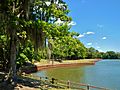
Roods Landing Site near Omaha.
-
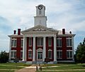
The Stewart County Courthouse in Lumpkin.
-
The Travis Usher House, built around 1836.
-
West Hill, a historic site in Lumpkin.

.jpg)
.jpg)
.JPG)

_(c._1890)_(Richland,_GA).JPG)


;_Lumpkin,_GA.JPG)

