
National Register of Historic Places listings in Sweetwater County, Wyoming facts for kids

Sweetwater County in Wyoming is home to many amazing places that are super old and important! These special spots are listed on something called the National Register of Historic Places. Think of it like a Hall of Fame for buildings, sites, and areas that tell us a lot about the past.
There are 36 of these cool places in Sweetwater County. One of them is even more special and is called a National Historic Landmark. This means it's super important to the history of the whole United States!
Contents
What is the National Register of Historic Places?
The National Register of Historic Places is an official list kept by the United States government. It includes buildings, structures, objects, sites, and districts that are important in American history, architecture, archaeology, engineering, or culture. When a place is added to this list, it means it's recognized as a valuable part of our heritage. It also helps protect these places and sometimes provides money to help keep them in good shape.
Sweetwater County's Historic Gems
Let's explore some of the cool historic places you can find in Sweetwater County!
Famous Landmarks
One of the most famous spots is Expedition Island in Green River. This island is a National Historic Landmark because it was a starting point for John Wesley Powell's famous boat trips down the Green and Colorado Rivers in 1869. Imagine explorers setting off from here on a big adventure!
Old Buildings and Town Centers
Many historic buildings in Sweetwater County show us how people lived and worked long ago.
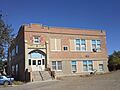
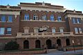
- The City Hall in Rock Springs is an old building that has served as the city's main office for a long time. It's where important decisions about the city are made.
- The Downtown Rock Springs Historic District isn't just one building; it's a whole area! It includes many old buildings in the heart of Rock Springs that show what the town looked like when it was growing.
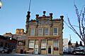
- The First National Bank Building in Rock Springs is another historic spot. Banks were very important for towns to grow, and this building shows the style of architecture from its time.
- In Green River, the Green River Downtown Historic District is similar, preserving the look and feel of the town's early days.
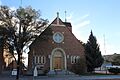
- Churches also play a big part in a community's history. Our Lady of Sorrows Catholic Church and Saints Cyril and Methodius Catholic Church and Rectory in Rock Springs are beautiful old churches that have been important to many families over the years.
- The Slovenski Dom in Rock Springs is a special building that was once a community hall for Slovenian immigrants. It was a place where people could gather, celebrate, and keep their culture alive.
- The South Superior Union Hall in Superior was a meeting place for coal miners. It tells a story about the hard work and community spirit of the people who worked in the mines.
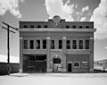
- The Sweetwater Brewery in Green River is an old building that used to make beer. It's a reminder of the businesses that helped towns grow in the past.
- The US Post Office-Green River is another historic building that shows how important mail service was for connecting communities.
Historic Travel Stops
Before cars and highways, people traveled by horse and wagon, often stopping at "stage stations."
- The Granger Station in Granger was a very important stop on the Pony Express and the Overland Stagecoach. It's one of the few original stage stations still standing!
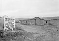
- The Point of Rocks Stage Station near Rock Springs was another key stop for stagecoaches and travelers crossing Wyoming.
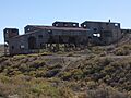
- The Laclede Station Ruin is what's left of another old stage station. Even though it's a ruin, it still tells a story about the long journeys people made.
Ancient History and Industry
Sweetwater County also has sites that show much older history and industrial past.
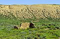
- The Tolar Petroglyph Site near Point of Rocks has ancient rock carvings made by early people. These carvings, called petroglyphs, give us clues about the lives of people who lived here thousands of years ago.
- The Reliance School and Gymnasium and the Reliance Tipple in Reliance are important for understanding the area's coal mining history. The school served the children of miners, and the tipple was a big structure used to load coal onto trains.
Other Cool Places
- The ETD Bridge over Green River and the ETR Big Island Bridge are historic bridges that helped people and goods cross the Green River. Bridges are vital for connecting places!
- The Elinore Pruitt Stewart Homestead near McKinnon was the home of a famous writer who wrote about her life as a homesteader in Wyoming. It gives us a peek into what life was like for pioneers.
- The Parting of the Ways is a historic spot where the Oregon Trail split into two different paths. It's a reminder of the thousands of pioneers who traveled through Wyoming on their way west.
These are just some of the many fascinating places in Sweetwater County that are protected because of their historical importance. Each one helps us understand the rich and varied past of Wyoming and the United States!
Images for kids
-
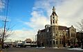
City Hall in Rock Springs
-
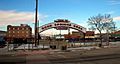
Downtown Rock Springs Historic District
-
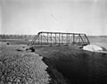
ETD Bridge over Green River
-
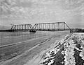
ETR Big Island Bridge
-
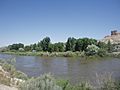
Expedition Island in Green River
-
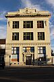
First National Bank Building in Rock Springs
-
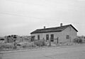
Granger Station
-
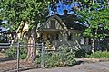
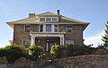
Gras House in Rock Springs
-
Laclede Station Ruin
-
Our Lady of Sorrows Catholic Church in Rock Springs
-
Point of Rocks Stage Station
-
Reliance School and Gymnasium
-
Reliance Tipple
-
Rock Springs Elks' Lodge No. 624
-

Slovenski Dom in Rock Springs
-
South Superior Union Hall
-
Sweetwater Brewery in Green River
-
Taliaferro House in Rock Springs
-

Tolar Petroglyph Site
-

Wardell Court Historic Residential District


.jpg)
_from_South_Street.jpg)


