
National Register of Historic Places listings in Talladega County, Alabama facts for kids

Have you ever wondered about old buildings and places that are super important to history? In Talladega County, Alabama, there are 24 special spots listed on the National Register of Historic Places. This list is like a hall of fame for buildings, areas, and objects that tell us about the past of the United States.
Two of these places are even more special! They are called National Historic Landmarks. This means they are recognized as being important to the history of the entire country, not just Alabama. Let's explore some of these amazing historic places in Talladega County!
Contents
- Discovering Talladega County's Historic Gems
- Historic Homes and Buildings
- Important Public Buildings and Districts
- B.B. Comer Memorial Library: A Center for Learning
- First Presbyterian Church: A Place of Worship
- Kymulga Mill & Covered Bridge: A Scenic Spot
- Hightower Brothers Livery Stable: A Business from the Past
- Talladega Courthouse Square Historic District: The Heart of the City
- Sylacauga Historic Commercial District: Downtown History
- Silk Stocking District: A Neighborhood's Story
- Historic Colleges and Institutions
- Images for kids
Discovering Talladega County's Historic Gems
Talladega County is full of history, and many of its old buildings and areas are protected. These places help us remember how people lived and what happened long ago. They are like living museums that we can visit and learn from.
Historic Homes and Buildings
Many of the places on the list are old homes or important buildings. They show us different styles of architecture and how people built things in the past.
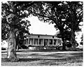
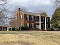
J.L.M. Curry House: A National Treasure
The J.L.M. Curry House is a very important home located near Talladega. It's so special that it's one of the two National Historic Landmarks in the county! J.L.M. Curry was a famous person who worked in politics and education. He helped shape schools and government in the late 1800s. His home is a reminder of his important work and the history of that time.
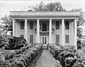
Boxwood: A Grand Old Home
In Talladega, you can find a beautiful old house called Boxwood. It's located on East North Street. This house was added to the National Register in 1983. It's a great example of the grand homes built in the area many years ago.
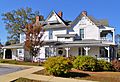
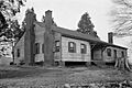
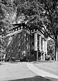
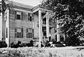
Charles Butler House: A Glimpse into the Past
The Charles Butler House is in Childersburg. It sits at the corner of 1st Street and 10th Avenue. This house was recognized in 1996. It helps us understand the history and architecture of Childersburg.
Goodwin-Hamilton House: A Countryside Gem
Out on Marble Valley Road near Sylacauga is the Goodwin-Hamilton House. This historic home was listed in 1986. It shows us what rural homes looked like in the past in Talladega County.
Lawler-Whiting House (Orange Vale): Southern Charm
South of Talladega on State Route 21, you'll find the Lawler-Whiting House, also known as Orange Vale. This house was listed in 1986. It has a classic Southern charm and tells stories of the families who lived there.
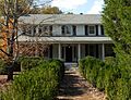
Thornhill: A Historic Residence
Another significant home is Thornhill, located on State Route 21 near Talladega. It was added to the National Register in 1998. Thornhill is a beautiful example of historic architecture in the region.
Winterboro Stagecoach Inn: A Stop on the Journey
The Winterboro Stagecoach Inn in Winterboro is a fascinating place. Located on State Route 21, it was listed in 2005. Imagine travelers stopping here for a rest when stagecoaches were the main way to travel! It's a great reminder of early transportation and hospitality.
Important Public Buildings and Districts
Besides homes, the list includes important public buildings and entire areas that have historical value.
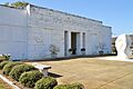
B.B. Comer Memorial Library: A Center for Learning
The B.B. Comer Memorial Library in Sylacauga is more than just a library. It was listed in 2005. Today, this building is home to the Isabel Anderson Comer Museum & Arts Center. It's a place where people can learn about art and history.
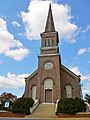
First Presbyterian Church: A Place of Worship
The First Presbyterian Church in Talladega, located on North Street, is a historic place of worship. It was recognized in 1983. Churches often play a big role in a community's history, and this one is no exception.
Kymulga Mill & Covered Bridge: A Scenic Spot
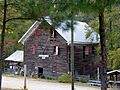
About 4.5 miles northeast of Childersburg, you'll find the Kymulga Mill & Covered Bridge. This unique spot was listed in 1976. It includes an old mill and a beautiful covered bridge, which are rare and important examples of early American engineering and industry. It's a very scenic and historic place to visit.
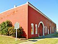
Hightower Brothers Livery Stable: A Business from the Past
In Sylacauga, the Hightower Brothers Livery Stable on Norton Avenue was listed in 1997. A livery stable was a place where people could rent horses and carriages, or keep their own horses. This building shows us what businesses were like before cars became common.
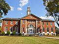
Talladega Courthouse Square Historic District: The Heart of the City
The Talladega Courthouse Square Historic District is the central part of Talladega. It includes the area around the courthouse square. This district was first listed in 1972, and its boundaries were later expanded. It's important because it shows how the city grew and developed around its main public square. Many historic buildings are found here.
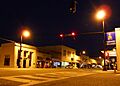
Sylacauga Historic Commercial District: Downtown History
The Sylacauga Historic Commercial District covers a large part of downtown Sylacauga. It was listed in 2004. This area is important because it shows how businesses and shops were set up in the past. It helps us understand the economic history of Sylacauga.
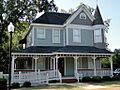
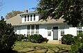
Silk Stocking District: A Neighborhood's Story
In Talladega, the Silk Stocking District is a historic neighborhood. It was listed in 1979. This area is known for its beautiful old homes and tree-lined streets. It tells the story of how people lived and built their communities in the past.
Historic Colleges and Institutions
Some of the most important historic places are connected to education.
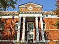
Swayne Hall, Talladega College: A Landmark of Learning
Swayne Hall is located on the campus of Talladega College. It's the second National Historic Landmark in Talladega County, listed in 1974. Talladega College is a historically Black college, and Swayne Hall is one of its oldest and most important buildings. It represents a long history of education and civil rights.
Talladega College Historic District: A Campus Full of History
The entire Talladega College Historic District was listed in 1990. This district includes many buildings on the college campus. It shows the growth and importance of this historic institution, which has played a huge role in American education.
Images for kids
-
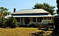
William Averiett House
-
Charles Butler House
-
B.B. Comer Memorial Library
-
J.L.M. Curry House
-
First Presbyterian Church
-
Hightower Brothers Livery Stable
-
Idlewild
-
Jemison House Complex
-
Kymulga Mill and Covered Bridge
-
Lawler-Whiting House (Orange Vale)
-
A home in the Silk Stocking District
-
Dudley Snow House
-
Swayne Hall
-
Sylacauga Historic Commercial District
-
Savery Library, Talladega College
-
Talladega County Courthouse
-
Thornhill
-
Welch-Averiett House
-
Winterboro Stagecoach Inn


.jpg)

.jpg)


.jpg)


