
National Register of Historic Places listings in Tuolumne County, California facts for kids

Imagine a special list that keeps track of important buildings, places, and areas in the United States. This list is called the National Register of Historic Places. It helps protect places that tell a story about our past. In Tuolumne County, California, there are many such places. They show us what life was like long ago, especially during the Gold Rush.
Currently, 34 places in Tuolumne County are on this list. Two of them are even more special, called National Historic Landmarks. These landmarks are extra important to the history of the entire country.
Contents
Exploring Historic Places in Tuolumne County
Tuolumne County is full of history, from old mining towns to beautiful natural parks. Many of its historic places are found in towns like Sonora, Jamestown, and Groveland. Other important sites are deep within Yosemite National Park.
Historic Buildings in Sonora
Sonora is the county seat of Tuolumne County and has several buildings on the National Register. These buildings often show the architecture and daily life from the Gold Rush era.
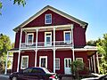
The Cady House
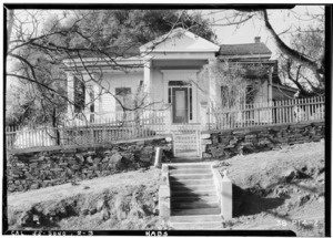
The Cady House is a beautiful old home located at 72 N. Norlin Street. It was added to the list in 1982. This house gives us a peek into how people lived in Sonora many years ago.
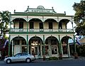
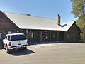
The City Hotel
The City Hotel at 145 S. Washington Street was listed in 1983. Hotels like this were very important places where travelers and miners stayed. They were also social hubs in the growing towns.

Tuolumne County Courthouse
The Tuolumne County Courthouse is located at 41 W. Yaney Avenue. It was added to the list in 1981. This building is where important legal decisions were made and where the county government operated. It's a key part of the county's civic history.

Tuolumne County Jail
Right near the courthouse, at 156 W. Bradford Street, is the Tuolumne County Jail. This jail was listed in 1978. It shows how law and order were kept in the early days of the county.

Gold Rush Era Sites
Many places in Tuolumne County are connected to the California Gold Rush. These sites help us understand the challenges and excitement of that time.
Columbia Historic District
The Columbia Historic District is about 4 miles northwest of Sonora. It became a National Historic Landmark in 1966. Columbia was once a very busy gold mining town. Today, it's preserved as a state historic park, showing what a Gold Rush town looked like.

The Emporium in Jamestown
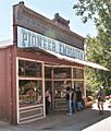
In Jamestown, the Emporium at 735 Main Street was listed in 1978. An emporium was a large store that sold many different kinds of goods. It was a vital place for miners and settlers to buy supplies.

Groveland's Historic Hotels
The town of Groveland also has historic buildings. The Groveland Hotel at 18767 Main Street was listed in 1994. The Hotel Charlotte at 18736 Main Street was listed in the same year. These hotels served travelers heading to and from Yosemite National Park and the gold fields.


Historic Sites in Yosemite National Park
A large part of Yosemite National Park is located in Tuolumne County. Several important historic sites within the park are also on the National Register.
Great Sierra Mine Historic Site
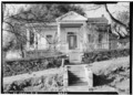
The Great Sierra Mine Historic Site is west of Lee Vining in Yosemite National Park. It was listed in 1978. This site reminds us that even in beautiful natural parks, there was once mining activity.

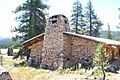
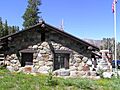
Parsons Memorial Lodge
The Parsons Memorial Lodge in Tuolumne Meadows became a National Historic Landmark in 1979. This lodge is a special building that blends into its natural surroundings. It was built to honor a conservationist and is a great example of early park architecture.

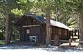
McCauley Cabin and Soda Springs Cabin
Also near Lee Vining in Tuolumne Meadows are the McCauley Cabin (listed 1977) and the Soda Springs Cabin (listed 1979). These cabins show the simple living conditions of early settlers and rangers in the high Sierra mountains.


Tuolumne Meadows
The entire area of Tuolumne Meadows itself was listed in 1978. This vast, beautiful meadow is not just a natural wonder but also a historic landscape. It has been used by people for thousands of years.

Tuolumne Meadows Ranger Stations
The Tuolumne Meadows Ranger Stations and Comfort Stations were listed in 1978. These buildings were important for park rangers who helped manage and protect the park. They also provided services for visitors.

Tioga Pass Entrance Station
The Tioga Pass Entrance Station is southwest of Lee Vining in Yosemite National Park. It was listed in 1978. This station is where visitors entering the park via Tioga Pass would stop. It's a historic gateway to the park.

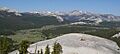
Yosemite Valley
The famous Yosemite Valley itself, located within Yosemite National Park, was listed as a historic district in 2006. This means the entire valley, with its stunning cliffs and waterfalls, is recognized for its historical importance in conservation and tourism.

Other Notable Historic Sites
Tuolumne County has many other interesting places on the National Register.
Baker Highway Maintenance Station
The Baker Highway Maintenance Station at 33950 CA 108 in Strawberry was listed in 2004. This station helped keep the roads open and safe for travelers, especially in the mountains.
Chinaman Mortar Site
The Chinaman Mortar Site near Strawberry was listed in 1975. This site is restricted, meaning its exact location is kept private to protect it. It is an archaeological site that tells us about the lives of early Chinese immigrants in the area.
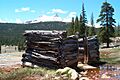
Gamble Building and Miner's Bean Kettle
In Big Oak Flat, the Gamble Building and Miner's Bean Kettle at 17544 CA 120 was listed in 1991. This unique site includes a building and a large kettle, likely used for cooking for many miners.

Niagara Camp
The Niagara Camp northeast of Tuolumne in Stanislaus National Forest was listed in 1975. This camp was likely a base for logging or mining operations in the past.
Quail Site
The Quail Site near Long Barn was listed in 1975. Like the Chinaman Mortar Site, its location is restricted to protect its archaeological value.
Sonora Youth Center
The Sonora Youth Center at 732 S. Barretta Street was listed in 2009. This building has served the community's young people for many years.

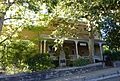
Sugg House
The Sugg House at 37 Theall Street in Sonora was listed in 1984. It is another example of the historic homes that make Sonora special.

Watts & Tannahill Company Store
In Groveland, the Watts & Tannahill Company Store at 18761 Main Street was listed in 1995. Company stores were common in mining towns, providing everything workers needed.

Images for kids
-
The Cady House in Sonora, built long ago.
-
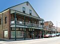
The historic City Hotel in Sonora.
-
A street in the Columbia Historic District.
-
The Emporium building in Jamestown.
-
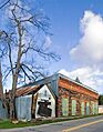
The Miner's Bean Kettle and Gamble Building.
-
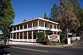
The historic Groveland Hotel.
-
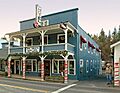
Hotel Charlotte in Groveland.
-

McCauley Cabin in Tuolumne Meadows.
-
Parsons Memorial Lodge in Tuolumne Meadows.
-
Soda Springs Cabin.
-
The Sonora Youth Center.
-
The Sugg House in Sonora.
-
The Tioga Pass Entrance Station.
-
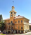
The Tuolumne County Courthouse.
-
The old Tuolumne County Jail.
-
Tuolumne Meadows, a historic landscape.
-
A ranger station in Tuolumne Meadows.
-

The Watts & Tannahill Company Store.
-

Yosemite Valley with Half Dome in the distance.
-
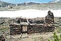
The Dana Cabin at the Great Sierra Mine site.
