
National Register of Historic Places listings in Turner County, South Dakota facts for kids

This page is about special old places and buildings in Turner County, South Dakota that are listed on the National Register of Historic Places. Think of this list as a way to keep track of important historical sites across the United States. These places are recognized because they tell us a lot about the past, like how people lived, worked, or what important events happened there.
In Turner County, there are 30 different places and areas that are currently on this special list. There were also 2 other places that used to be on the list but have since been removed.
What is the National Register of Historic Places?
The National Register of Historic Places is like a big honor roll for buildings, places, and objects that are important to American history. It's managed by the National Park Service, which is part of the U.S. government. When a place is added to this list, it means it's recognized for its historical, architectural, archaeological, engineering, or cultural importance.
Being on the list helps protect these places. It doesn't mean the government owns them, but it does encourage people to take care of them. It can also help owners get special grants or tax breaks to fix up and preserve these historic sites. It's all about making sure we remember and learn from the past!
Cool Old Buildings and Bridges in Turner County
Turner County has many interesting places on the National Register. Most of them are old houses, farms, and bridges. These structures show us how people built things a long time ago and how they lived their lives.
Historic Homes and Farms
Many of the listed places are old homes and farmsteads. For example, the Bones Hereford Ranch Sale Barn near Parker is a historic building used for selling cattle. It shows how important farming and ranching were, and still are, to the area.
Other homes like the Brough-Martinson House and the Farrar House in Hurley give us a peek into the past lives of families in the county. The Dr. Harry S. Graves House is another example of a historic home. These houses often have unique designs or were owned by important people in the community.
The Tenus Isaac Gunderson House and the William Higinbotham House in Centerville are also on the list. These homes are great examples of older architecture. The Chandler Gray and Mary Abbie Newhall House and Homestead Shack near Parker tells a story of early settlers. The Thielman-Stoddard House in Parker and the James S. Thomson House in Centerville are also recognized for their historical value.
A unique listing is the Jacob Weins House-Barn near Marion. This shows how some early settlers built their homes and barns together. The Wek Farmstead near Freeman is another example of a historic farm, showing how agriculture shaped the region.
Important Old Bridges
Many bridges in Turner County are also on the National Register. These bridges are important because they show old ways of building and engineering. They helped people travel and transport goods across rivers and streams.
Some examples include:
- Bridge No. 63-137-090-Parker: This bridge near Parker crosses a small stream.
- Centerville Township Bridge Number S-18: Located in Centerville, this bridge is a good example of early 2000s bridge design.
- Childstown Township Bridge Number S-15: Found in the Childstown area.
- Dalton Township Bridge: This bridge near Marion is also recognized.
- Daneville Township Bridge No. E-26: Located near Viborg.
- Germantown Township Bridge S-29: This bridge is in the Germantown area.
- Salem Township Bridge Number E-1: Found near Salem.
- Several South Dakota Department of Transportation Bridges (like No. 63-016-150 near Marion, No. 63-052-030 near Marion, No. 63-132-040 near Parker, No. 63-160-056 near Parker, No. 63-197-130 near Davis, No. 63-198-181 near Davis, and No. 63-210-282 near Centerville) are also listed. These bridges are important examples of how roads and transportation developed in the state.
- Spring Valley Township Bridge No. E-31: This bridge is near Viborg.
- Turner Township Bridge No. SE-18: Located near Centerville.
These bridges are not just ways to cross water; they are also pieces of history that show us how engineers and builders worked in the past.
Other Notable Sites
The Archeological Site 39TU5 near Freeman is a very special listing. Archeological sites are places where scientists study human history through digging up old objects and remains. This site helps us learn about people who lived in Turner County long, long ago.
The Glud Theatre in Viborg is another interesting place. Theaters are important for showing how communities gathered for entertainment and culture. The Parker Masonic Hall in Parker is also listed. Masonic halls are buildings used by a fraternal organization, and they often have unique architecture and a history of community involvement.
Places That Used to Be Listed
Sometimes, a place is removed from the National Register. This can happen if the building is changed too much, or if it is unfortunately destroyed. In Turner County, two places were once listed but are no longer on the Register:
- The I.O.O.F. Hall, Hurley Lodge No. 75 in Hurley was delisted in 1988.
- Two South Dakota Department of Transportation Bridges (No. 63-177-160 near Hurley and No. 63-186-020 near Parker) were delisted in 2008.
These former listings still remind us of the rich history of Turner County, even if they are no longer officially on the Register.
Images for kids
-
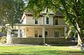
The Tenus Isaac Gunderson House in Centerville.
-
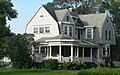
The William Higinbotham House in Centerville.
-
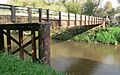
A bridge over the Vermillion River near Centerville.
-
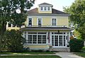
The James S. Thomson House in Centerville.


