
National Register of Historic Places listings in Van Buren County, Arkansas facts for kids

Have you ever wondered about the oldest and most important buildings and places around you? In Van Buren County, Arkansas, there's a special list of places that are super important to history. This list is called the National Register of Historic Places. It helps protect buildings, areas, and objects that tell us a lot about the past of the United States.
This article will tell you about 16 amazing places in Van Buren County that are on this special list. Some are old houses, some are bridges, and some are even whole areas with many historic buildings! By learning about these places, we can understand more about how people lived long ago and what was important to them.
Contents
Cool Historic Buildings and Places
These are some of the interesting spots in Van Buren County that have been recognized for their history.
Homes with a Story
Many old houses in the county have been preserved because they show us how people lived in the past.
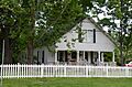
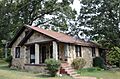
Melvin Chrisco House
The Melvin Chrisco House is located in Damascus. It was added to the National Register in 2005. This house is a great example of the kind of homes built in the area a long time ago.
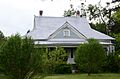
Collums-Baker House
You can find the Collums-Baker House near Bee Branch. It was listed in 1992. This house stands out as an important part of the local history and architecture.
Joclin-Bradley-Bowling House
In Clinton, there's the Joclin-Bradley-Bowling House. It joined the list in 2007. This house has a unique design that tells us about building styles from its time.
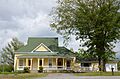
Carl and Esther Lee House
Another interesting home in Damascus is the Carl and Esther Lee House. It was added to the National Register in 2005. It's a well-preserved example of a historic home.
Walter Patterson House
The Walter Patterson House is also in Clinton. It became a historic listing in 2007. This house is known for its special design and history.
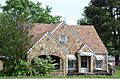
Art Scanlan House
Near Bee Branch, you'll find the Art Scanlan House. It was listed in 1999. This house is a significant part of the area's past.
Important Community Spots
These places were central to community life or played a big role in local history.
Clinton Commercial Historic District
The Clinton Commercial Historic District is an area in Clinton with many historic buildings. It's roughly bordered by Town Branch Creek and U.S. Highway 65B. This district was recognized in 2006 because its buildings together show what the town's business area looked like long ago.
Damascus CCC Camp, Co. No. 3781 Historic District
In Damascus, there's a historic district that was once a camp for the Civilian Conservation Corps (CCC). The CCC was a program during the Great Depression that helped young men find work. This district was listed in 2002 and shows us how these camps were set up.
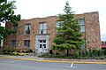
Damascus Gymnasium
The Damascus Gymnasium is located on Highway 285 in Damascus. This old gym was added to the National Register in 1992. It was an important place for sports and community events for many years.
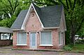
Walter Patterson Filling Station
The Walter Patterson Filling Station is in Clinton, on U.S. Highway 65. It was listed in 2001. This old gas station gives us a peek into how people traveled and bought fuel a long time ago.
Van Buren County Courthouse
The Van Buren County Courthouse is a very important building in Clinton. It's located at the corner of Griggs and Main Streets. This courthouse, listed in 1991, is where many important decisions for the county have been made over the years.
Bridges and Other Structures
Even bridges can be historic! They show us how people built things and traveled in the past.
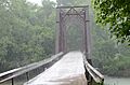
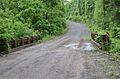
Middle Fork of the Little Red River Bridge
The Middle Fork of the Little Red River Bridge is a historic bridge near Shirley. It crosses the Middle Fork of the Little Red River on County Road 125. This bridge was added to the list in 2010.
Van Buren County Road 2E Bridge
Another historic bridge is the Van Buren County Road 2E Bridge, located near Scotland. It crosses a small stream called a tributary of Driver's Creek. This bridge was recognized in 1995.
Titan II ICBM Launch Complex 374-7 Site
This site, located west of U.S. Highway 65 near Southside, is a very unique historic place. It was once a launch complex for a Titan II missile. It was listed in 2000 and represents an important part of the Cold War era.
Places with Restricted Addresses
Some historic places, like archaeological sites or private homes, have their exact addresses kept secret to protect them.
Edgemont Shelter
The Edgemont Shelter is a historic site near Shirley. Its address is restricted to protect it. It was listed in 1982.
Lynn Creek Shelter
Another site with a restricted address is the Lynn Creek Shelter, near Fairfield Bay. It was added to the list in 1978.
Former Listings
Sometimes, a place might be removed from the National Register of Historic Places. This can happen if it is destroyed or changes too much.
Stobaugh House
The Stobaugh House was once on the National Register. It was located near Choctaw. It was listed in 1976 but was later removed from the list in 2000.
Images for kids
-

The Melvin Chrisco House in Damascus.
-
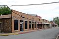
A building in the Clinton Commercial Historic District.
-
The Collums-Baker House near Bee Branch.
-
A structure from the Damascus CCC Camp.
-
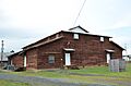
The historic Damascus Gymnasium.
-
The Joclin-Bradley-Bowling House in Clinton.
-
The Carl and Esther Lee House in Damascus.
-
The Middle Fork of the Little Red River Bridge.
-
The Walter Patterson Filling Station in Clinton.
-
The Walter Patterson House in Clinton.
-
The Art Scanlan House near Bee Branch.
-
The Van Buren County Courthouse in Clinton.
-
The Van Buren County Road 2E Bridge.


