
National Register of Historic Places listings in Yates County, New York facts for kids

Have you ever wondered about old buildings and places that are super important to history? In Yates County, New York, there are many special spots that are officially recognized for their historical value! These places are listed on the National Register of Historic Places. It's like a special club for buildings, areas, and objects that tell us amazing stories about the past.
When a place is on this list, it means it's considered important for its history, architecture, or what it represents about American culture. It helps protect these places so future generations can learn from them too. You can even see many of these places on a map if you click on "Map of all coordinates" (though that's more for grown-ups!).
Contents
What is the National Register of Historic Places?
The National Register of Historic Places is the official list of the United States' historic places worth saving. It's managed by the National Park Service. Think of it as a national treasure map, but instead of gold, it points to important historical sites!
Why are places listed?
Places get listed for many reasons:
- They might be very old and show how people lived long ago.
- They could be beautiful examples of a certain type of building style.
- Famous people might have lived or worked there.
- Important events might have happened there.
Being on the list helps people understand and appreciate these sites. It can also help protect them from being changed or torn down.
Historic Places in Yates County
Yates County is full of history, and many of its buildings and areas are on the National Register. Let's explore some of them!
Homes with History
Many of the listed places are old houses, often called "farmhouses." These homes tell us about the families who settled here and how they lived. Some are even built with a special style called "cobblestone," where smooth, rounded stones are used to build the walls.
- The Angus Cobblestone Farmhouse and Barn Complex in Benton was listed in 1992. It's a great example of those unique cobblestone buildings.
- The Barden Cobblestone Farmhouse, also in Benton, is another cool cobblestone house from 1992.
- The Bates Cobblestone Farmhouse in Middlesex shows us more of this special building style.
- The Jephtha Earl Cobblestone Farmhouse in Benton is another historic cobblestone home.
- The William Nichols Cobblestone Farmhouse in Benton also features this interesting construction.
- The Dr. Henry Spence Cobblestone Farmhouse and Barn Complex in Starkey is another example of these unique homes.
- The Daniel Supplee Cobblestone Farmhouse in Starkey is also built with cobblestones.
- The Young-Leach Cobblestone Farmhouse and Barn Complex in Torrey completes our list of these special stone houses.
Besides cobblestone houses, there are many other historic homes:
- The Jonathan Bailey House in Milo was listed in 1994.
- The Peter Bitley House and Thomas Bitley House, both in Jerusalem, are also on the list.
- The Samuel Botsford House in Jerusalem and the John Briggs House in Milo Center are other examples of historic homes.
- The John Carr House in Middlesex and the Thomas Bennett Curtis House in Starkey also have historical importance.
- Esperanza in Jerusalem, listed in 1995, is a significant historic property.
- The James Fox House in Italy and the Asahel Green Farm in Middlesex are also recognized.
- The Uriah Hair House in Dundee and Hampstead in Jerusalem are important historic homes.
- The Uriah Hanford House and George Hays House, both in Jerusalem, are also listed.
- The James Hobart House in Potter and the Smith McLoud House in Italy are on the list.
- The Roderick M. Morrison House in Penn Yan and the John Noyes House in Starkey are also recognized.
- The Ezikial Perry House in Jerusalem and the Arnold Potter House in Potter are historic homes.
- The Miles Raplee House in Milo and the Sill Tenant House in Jerusalem are also listed.
- The Spicer-Millard House in Barrington and the William Swarthout Farm in Milo are important.
- The William Swortz House in Starkey and the Abraham Wagener House in Jerusalem are also on the list.
- The Charles Wagener House in Penn Yan and the H. Allen Wagener House in Jerusalem are recognized.
- The Myron Weaver House and Solomon Weaver House, both in Branchport, are historic.
- The Whitaker House in Benton and the Jemima Wilkinson House in Jerusalem are also listed.
- The Sherman Williams House and Fruit Barn in Jerusalem and the Christopher Willis House in Dresden are important.
- The Milton Wilson House in Rushville and the Abner Woodworth House in Benton are also recognized.
- Finally, the Dr. James Wrightman House in Branchport is another historic home on the list.
Important Buildings and Districts
It's not just houses! Other types of buildings and even whole areas can be historic.
- The Dundee Methodist Church and the First Presbyterian Church in Dundee are both beautiful old churches that are important to the community's history.
- The Himrod Baptist Church in Milo and the Italy Valley Methodist Church in Italy are also historic churches.
- The Middlesex Center Methodist Church in Middlesex and the St. Luke's Episcopal Church in Jerusalem are listed.
- The Starkey United Methodist Church in Starkey and the Vine Valley Methodist Church in Middlesex are also recognized.
- The Yatesville Methodist Church in Potter is another historic church.
Some places are important because of what they taught people:
- The Overackers Corners Schoolhouse in Middlesex is an old schoolhouse, reminding us how kids used to learn.
Other buildings are famous for different reasons:
- The Robert Ingersoll Birthplace in Dresden is where a very famous speaker and writer was born.
- The Sampson Theatre in Penn Yan is an old theater, a place where people used to go for entertainment.
- The U.S. Post Office in Penn Yan is a historic building where people send and receive mail.
Sometimes, a whole area is important:
- The Crooked Lake Outlet Historic District stretches along the Keuka Lake Outlet Trail from Penn Yan to Dresden. This area is important because of its history related to the lake and how people used its water.
- The Dundee Village Historic District includes Main, Water, and Seneca Streets in Dundee. This means many buildings in this part of town are historically significant together.
- The Penn Yan Historic District covers a large part of downtown Penn Yan. It's a whole neighborhood filled with historic buildings!
- The Yates County Courthouse Park District in Penn Yan includes the courthouse and the park around it, showing important government history.
Even cemeteries can be historic:
- The Beddoe–Rose Family Cemetery in Jerusalem is a burial ground for an early family who helped settle the area.
- The Lake View Cemetery in Penn Yan is also a historic cemetery.
These places help us remember the past and understand how Yates County grew and changed over time. They are like open-air museums, each with a unique story to tell!
Images for kids
-
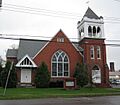
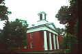
Dundee Methodist Church
-
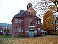
Greater Dundee Historical Society in the Dundee Village Historic District
-
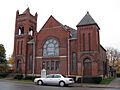
First Presbyterian Church in Dundee
-
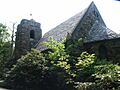
Garrett Memorial Chapel
-
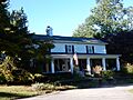
Robert Ingersoll Birthplace
-
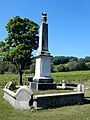
Lake View Cemetery
-
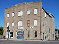
Sampson Theatre
-
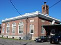
U.S. Post Office in Penn Yan
-
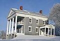
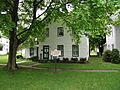
Abraham Wagener House
-
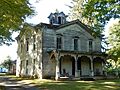
Charles Wagener House
-
Christopher Willis House
-
Yates County Courthouse


