
National Register of Historic Places listings in Yellowstone County, Montana facts for kids

Have you ever wondered about the old buildings and special places in your town? In Yellowstone County, Montana, there are many amazing spots that are part of the National Register of Historic Places. This is a special list kept by the United States government. It helps protect places that are important to history, architecture, archaeology, engineering, or culture.
Yellowstone County has 44 places on this list! Two of them are even more special and are called National Historic Landmarks. These landmarks are super important to the history of the entire country. Let's explore some of these cool places and learn why they are so special!
Contents
Exploring Yellowstone County's Historic Treasures
Yellowstone County is full of history, from ancient caves to grand old buildings. Each place tells a story about the past. Protecting these sites helps us remember where we came from and learn about the people who lived here before us.
Ancient Wonders: Pictograph Cave and Pompeys Pillar
Some of the most exciting historic places in Yellowstone County are very, very old! They show us how people lived thousands of years ago.
Pictograph Cave: A Window to the Past
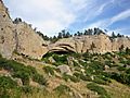
Imagine a cave where ancient people drew pictures on the walls! That's what you'll find at Pictograph Cave. It's located about 7 miles southeast of Billings in Indian Caves Park. This cave is a National Historic Landmark because it holds incredible rock art, or "pictographs," made by early Native Americans. These drawings tell stories about their lives, hunting, and beliefs. It's like a giant history book written on stone! The cave also has artifacts from people who lived there over 2,000 years ago.
Pompeys Pillar: A Famous Landmark
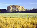
Another amazing National Historic Landmark is Pompeys Pillar. This huge rock formation stands tall west of Pompey's Pillar. It's famous because William Clark of the Lewis and Clark Expedition carved his name and the date (July 25, 1806) into the rock. It's the only remaining physical evidence of the expedition along the entire trail! Native American tribes also used this pillar as a landmark for thousands of years, leaving behind their own carvings and stories.
Historic Buildings in Billings
Many of the historic places in Yellowstone County are beautiful old buildings, especially in the city of Billings. These buildings show us how people lived, worked, and played in the past.
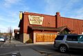
The Babcock Theatre Building
The Babcock Theatre Building at 114-124 N. 28th & 2808-2812 2nd Aves. in Billings is a great example of old architecture. The Babcock Theatre was once a popular place for people to watch movies and shows. It's a reminder of how entertainment has changed over the years.
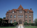
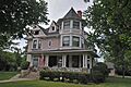
The Moss Mansion: A Grand Home
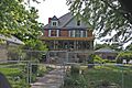
The Moss Mansion is a stunning house located at 914 Division St. in Billings. It was built for Preston B. Moss, a wealthy businessman, in the early 1900s. This mansion is a beautiful example of historic architecture and gives us a peek into the lives of prominent families from long ago. You can even take tours to see its fancy rooms and learn about the family who lived there.
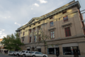
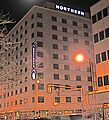
The Northern Hotel: A Place to Stay
The Northern Hotel at 19 N. Broadway in Billings has a long and interesting history. Hotels like this were very important in the past, providing places for travelers and business people to stay. The Northern Hotel has been rebuilt and restored over the years, but it still keeps its historic charm.
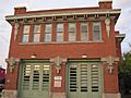
Old Fire House No. 2
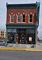
Imagine a time before modern fire trucks! The Fire House No. 2 at 201 E. 30th St. in Billings was once a busy place, protecting the city from fires. It's a cool example of the buildings that housed essential services in the past.
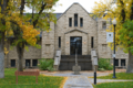
The Western Heritage Center (Parmly Billings Memorial Library)
The Western Heritage Center at 2822 Montana Ave. in Billings was originally the Parmly Billings Memorial Library. Libraries are important places for learning and community. This building now serves as a museum, preserving and sharing the history and culture of the Yellowstone River Valley.
Historic Districts: Whole Neighborhoods of History
Sometimes, it's not just one building that's historic, but a whole group of buildings or a neighborhood! These are called historic districts.
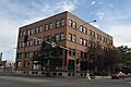
Billings Historic District
The Billings Historic District covers an area roughly bounded by N. 23rd and N. 25th Sts. and 1st and Montana Aves. This district includes many buildings that show what Billings looked like as it grew. It's like stepping back in time to see the city's early days.
Billings Old Town Historic District
Another important area is the Billings Old Town Historic District. This district is generally bounded by Montana Ave. on the north, S. 26th on the east, 1st Ave., S on the south, and S. 30th St. on the west. It includes many of the oldest parts of Billings, showing the original layout and buildings from when the city was first established.
Laurel Downtown Historic District
The town of Laurel also has its own historic district. The Laurel Downtown Historic District is roughly bounded by the Burlington Northern Santa Fe Railway Company tracks to the south, Third St., S. to the north, and Wyoming Ave. This area shows the historic heart of Laurel, with buildings that tell the story of its development.
Other Interesting Places
Yellowstone County has many other unique historic sites.
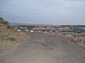
Black Otter Trail
The Black Otter Trail is a historic trail in Billings. Trails like this are important because they show us how people traveled and explored the land long ago.
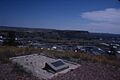
Boothill Cemetery
North of Billings, you'll find Boothill Cemetery. Old cemeteries are often considered historic places because they hold the graves of early settlers and important figures, telling stories of the community's past.
Dude Rancher Lodge
The Dude Rancher Lodge at 415 N. 29th St. in Billings is a unique historic building. Dude ranches were popular in the American West, offering visitors a taste of ranch life. This lodge is a reminder of that era.
These are just a few of the many amazing historic places in Yellowstone County. Each one helps us understand the rich history of Montana and the people who shaped it.
Images for kids
-
Armour Cold Storage
-
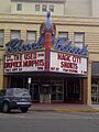
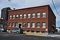
Babcock Theatre Building
-
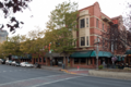
Billings Historic District
-
Yukon Bar in Billings Old Town Historic District
-
Black Otter Trail
-
Boothill Cemetery
-
Dude Rancher Lodge
-

Electric Building
-
Fire House No. 2
-
L and L Building
-
Masonic Temple
-
McMullen Hall
-
Moss Mansion
-
Northern Hotel
-
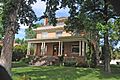
I.D. O'Donnell House
-
Oliver Building
-
Western Heritage Center (Parmly Billings Memorial Library)
-
Pictograph Cave
-
Pompey's Pillar
-
Prescott Commons
-
U.S. Post Office and Courthouse-Billings
-
Christian Yegen House
-
Peter Yegen House


_-_Yellowstone_County,_Montana_2.png)


_-_Yellowstone_County,_Montana.png)


_-_Yellowstone_County,_Montana.png)


_-_Yellowstone_County,_Montana.png)


