Navigation Structures at Harbor Beach Harbor facts for kids
Quick facts for kids |
|
|
Navigation Structures at Harbor Beach Harbor
|
|
 |
|
| Location | N. Lakeshore Dr., Harbor Beach, Michigan |
|---|---|
| Area | 5.6 acres (2.3 ha) |
| Built | 1873 |
| Architect | Major G. Weitzel, Charles P. Glibert, |
| Architectural style | Utilitarian |
| NRHP reference No. | 97000972 |
| Added to NRHP | September 11, 1997 |
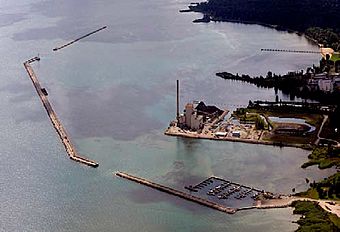
The Navigation Structures at Harbor Beach Harbor are like giant protective walls. They are called breakwaters. These walls are found in Lake Huron, near North Lakeshore Drive in Harbor Beach, Michigan. They were added to the National Register of Historic Places in 1997 because they are important historically.
Contents
Building a Safe Harbor
Early Days and First Lights
Back in the mid-1800s, sailing across Saginaw Bay could be quite dangerous. If a big storm came, the closest safe spot for ships was 80 miles away. That was the mouth of the St. Clair River. Ship captains really wanted a closer, safer place to hide from storms.
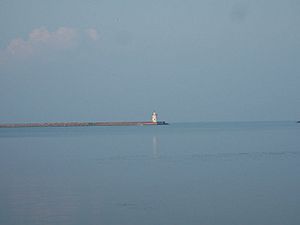
So, in 1872, this spot in Harbor Beach was chosen. Building the breakwaters started in 1873. By 1875, a simple light tower was put up. It helped ships find the entrance to the harbor, even though it wasn't finished yet. The Harbor Beach Light you see today was built in 1885. That same year, the main breakwater construction was completed. The whole project cost about $975,000, which was a lot of money back then!
Stronger Walls for the Future
By 1903, the original wooden parts of the breakwaters were starting to get old and fall apart. The next year, the Army Corps of Engineers began to fix them. They replaced the old wooden tops with strong concrete.
The main breakwater was finished with its new concrete top by 1909. The northern and southern parts got their concrete tops a few years later. This happened between 1911 and 1917. The breakwaters were repaired again in the late 1960s and early 1970s. More repairs were done in the 1980s to keep them strong.
What Do They Look Like?
The navigation structures are very long, almost 7,900 feet in total. That's about 1.5 miles of protective walls around the Harbor Beach harbor! These walls are made from wooden boxes filled with rocks. This is called stone-filled cribwork.
The breakwater is built in three main parts. The first part stretches about 1,500 feet to the east. It starts about three-quarters of a mile north of the dock. There's a gap of about 300 feet before the next section. This second part goes about 300 feet east, then 3,960 feet southeast, and another 300 feet east.
There's a 600-foot gap for ships to enter the harbor. After this entrance, the final section of breakwater runs 1,900 feet to the south. The inside of the harbor is kept deep enough for ships, about 23 feet deep. The famous Harbor Beach Light sits right on the breakwater at the harbor's entrance. All the breakwaters have a strong concrete top.


