Neahkahnie Beach, Oregon facts for kids
Quick facts for kids
Neahkahnie Beach, Oregon
|
|
|---|---|

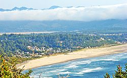
View of Neahkanie Beach, Manzanita, and Nehalem Bay from Oswald West State Park
|
|
| Country | United States |
| State | Oregon |
| County | Tillamook |
| Elevation | 85 ft (26 m) |
| Time zone | UTC-8 (Pacific (PST)) |
| • Summer (DST) | UTC-7 (PDT) |
| ZIP code |
97131
|
| Area code(s) | 503 and 971 |
Neahkahnie Beach, also known simply as Neahkahnie, is a small community in Tillamook County, Oregon, United States. It is not an official city but is recognized for statistical purposes. This area is found west of U.S. Route 101. It sits at the base of Neahkahnie Mountain. The community has about 370 homes. It is located just north of the city of Manzanita.
About Neahkahnie Beach
Neahkahnie Beach is called a "census-designated place" (CDP). This means the United States Census Bureau defines it for counting people. It helps gather information about the population. It is also an "unincorporated community." This means it does not have its own local government. Instead, it is part of the larger Tillamook County.
Location and Features
Neahkahnie Beach is a coastal community. It offers beautiful views of the Pacific Ocean. The area is known for its natural beauty. It is close to Neahkahnie Mountain. This mountain is a well-known landmark in the region. The community is a quiet place. Many people enjoy visiting the beach and the surrounding nature.
Population
The population of Neahkahnie Beach is quite small. According to the 2020 Census, 197 people lived there. This makes it a peaceful and less crowded area. The number of people living in a CDP is counted by the government. This helps understand how communities are growing or changing.
See also
 In Spanish: Neahkahnie Beach para niños
 | Bessie Coleman |
 | Spann Watson |
 | Jill E. Brown |
 | Sherman W. White |


