
Neerijnen facts for kids
Quick facts for kids
Neerijnen
|
|||
|---|---|---|---|
|
Village and former municipality
|
|||
.jpg)
Castle Neerijnen
|
|||
|
|||
.svg)
Location in Gelderland
|
|||

Neerijnen
Location in Gelderland

Neerijnen
Location in Netherlands
|
|||
| Country | Netherlands | ||
| Province | Gelderland | ||
| Municipality | West Betuwe | ||
| Merged | 2019 | ||
| Area | |||
| • Total | 6.11 km2 (2.36 sq mi) | ||
| Elevation | 3 m (10 ft) | ||
| Population
(2021)
|
|||
| • Total | 465 | ||
| • Density | 76.10/km2 (197.1/sq mi) | ||
| Time zone | UTC+1 (CET) | ||
| • Summer (DST) | UTC+2 (CEST) | ||
| Postcode |
4182
|
||
| Area code | 0418 | ||

Neerijnen is a small village in the Netherlands. It used to be its own municipality (like a local government area), but it joined with other towns in 2019. Now, it's part of the new municipality called West Betuwe.
Neerijnen is located about 35 kilometers (22 miles) south of Utrecht and 15 kilometers (9 miles) north of 's-Hertogenbosch. In 2021, about 465 people lived there.
A Look at Neerijnen's Past
Neerijnen is quite old! It was first mentioned in written records way back in the year 996. The name "Neerijnen" might mean "lower Ine," possibly compared to a nearby place called Opijnen ("upper Ine").
The village grew along the dike of the Waal river. This dike helps protect the land from floods.
Neerijnen Castle
One of the most famous buildings in Neerijnen is
Neerijnen Castle was built around the year 1350. For a long time, it was part of the same estate as Waardenburg Castle.
During a war in 1574, the castle was attacked by William the Silent and was mostly destroyed. But don't worry, it was rebuilt in 1627! For many years, starting in 1980, the castle was used as the town hall for the Neerijnen municipality. When Neerijnen merged into West Betuwe in 2019, the castle was put up for sale.
In 1840, about 294 people lived in Neerijnen. The village's Dutch Reformed Church was built in 1865.
Nearby Villages
When Neerijnen was its own municipality, it included several other villages. These villages are now also part of West Betuwe. They include:
- Est
- Haaften
- Heesselt
- Hellouw
- Ophemert
- Opijnen
- Tuil
- Varik
- Waardenburg
Location on the Map

This map shows the area that used to be the municipality of Neerijnen in June 2015. Topographic maps show details about the land, like rivers, roads, and how high the land is.
Gallery
-
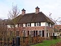
A house in Neerijnen.
-
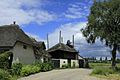
A farm with a haystack in Neerijnen.
-
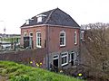
A restaurant located on the dike in Neerijnen.


.jpg)
