Neponset, California facts for kids
Quick facts for kids
Neponset
|
|
|---|---|

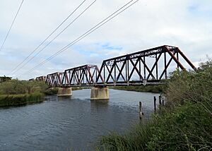
A railroad bridge over the Salinas River at Neponset
|
|
| Country | United States |
| State | California |
| County | Monterey |
| Elevation | 187 ft (57 m) |
| • Summer (DST) | UTC-7 (PDT) |
| ZIP code |
93908
|
| Area code | 831 |
Neponset is a small, unincorporated community in Monterey County, California. An "unincorporated community" means it's a place with people living there, but it doesn't have its own local government like a city or town.
This community is located along the Southern Pacific Railroad tracks. It's also found near California State Route 1, a famous highway. Neponset sits between the towns of Marina, California and Castroville, California. It is about 8.5 miles (13.7 kilometers) northwest of Salinas, California. The area is about 23 feet (7 meters) above sea level.
Contents
A Look Back: History of Neponset
Neponset wasn't always called Neponset! Before 1900, it was known as Martin Station.
Early Days as Martin Station
Back in 1890, Martin Station was a small farming area. It had a school house where local children learned. There were also several ranches spread across the land.
Becoming Neponset
In 1900, the community changed its name to "Neponset." This new name came from a place called Neponset in Boston, Massachusetts. In the early 1900s, local newspapers like The Californian often shared news about families living in Neponset. People in the community even started a group called the Neponset Temperance Club. This club was formed by men who wanted to encourage people to avoid alcohol.
Railroad Connections in Neponset
The railroad has always been an important part of Neponset.
Tracks and Roads
Today, you can still see the old railroad tracks near the Dole Food Company plant. These tracks are important for moving goods. Monte Road is a smaller road that runs next to State Route 1. It helps people get around the area. Neponset Road also goes around the southern side of the Dole plant.


