Nesconset, New York facts for kids
Quick facts for kids
Nesconset, New York
|
|
|---|---|

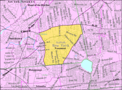
U.S. Census map
|
|
| Country | |
| State | |
| County | Suffolk |
| Town | Smithtown |
| Area | |
| • Total | 3.83 sq mi (9.91 km2) |
| • Land | 3.82 sq mi (9.90 km2) |
| • Water | 0.00 sq mi (0.01 km2) |
| Elevation | 118 ft (36 m) |
| Population
(2020)
|
|
| • Total | 13,207 |
| • Density | 3,455.52/sq mi (1,334.33/km2) |
| Time zone | UTC-5 (Eastern (EST)) |
| • Summer (DST) | UTC-4 (EDT) |
| ZIP code |
11767
|
| Area codes | 631, 934 |
| FIPS code | 36-49825 |
| GNIS feature ID | 0958373 |
Nesconset is a community in New York, United States. It is known as a hamlet and a census-designated place (CDP). This means it's a small, unincorporated area that the government tracks for population numbers. Nesconset is located within the Town of Smithtown, in Suffolk County, on Long Island. In 2020, about 13,207 people lived there.
Contents
History of Nesconset
Early Days and Native Americans
Long ago, before European settlers arrived, the area that is now Nesconset was likely a place where Native American groups went to hunt during certain seasons. These groups included people who spoke Algonquin and Munsee languages. They often lived in family groups called clans and would sometimes join together in winter to share food or protect themselves from dangers.
By the 1700s, many Native Americans on Long Island had been affected by conflicts and diseases brought by European settlers. Their numbers had greatly reduced, and they lived in special areas called reservations or mission-towns. One of these groups, known as the Nissequogue or Nesaquake, lived in early Smithtown. Their main leader, or sachem, was named Nassaconsett or Nassetteconsett. Nesconset was later named after him.
After a law was passed in Smithtown in 1768 that changed how Native Americans could live, Nesconset remained mostly an empty area with many pine trees and sandy soil, known as "pine barrens." However, when the Middle Country Road (NY 25) was built around the same time, it slowly opened the area for farming.
Growth and Development
By the early 1800s, a few farmers and people who visited only in the summer lived along Middle Country Road and near Lake Ronkonkoma. There were also some basic roads like Gibbs Pond Road and Smithtown Boulevard.
In 1904, two brothers from France, Louis and Clemen Vion, often visited the pine barrens in southeastern Smithtown for sports. By 1910, they cleared a line of trees off Gibbs Pond Road to create Midwood Avenue and built their home there.
As more people moved to the area, a lumber yard, a general store, and a post office were built in 1908. The historic Nesconset Schoolhouse was built in 1910, and the Nesconset Fire Department was built by 1935. A small town center started to form where Lake Avenue South and Gibbs Pond Road meet. The Vion brothers decided to name the new settlement Nesconset, after the Native American leader Nasseconsett. Later, more homes were built, especially summer houses, around Lake Avenue South, Southern Boulevard, and the Lake Ronkonkoma area.
By 1930, Nesconset had about 50 people living along Lake Avenue and spreading out along Smithtown Boulevard and Gibbs Pond Road. In the 1950s, the building of New York State Route 347 helped the area grow quickly with new neighborhoods. This new road went right through the small center of Nesconset, causing the main business area to move to Smithtown Boulevard.
Geography
Nesconset covers about 3.8 square miles (9.9 square kilometers) of land.
In the early 1970s, the official area of Nesconset was made larger. It now includes a part of what used to be Lake Ronkonkoma, New York. This expanded area stretches from Gibbs Pond Road east to School House Road and from Brown's Road south to Smithtown Boulevard.
Population Information
Recent Population Counts
- As of the 2020 census, Nesconset had a population of 13,207 people.
- In the 2010 census, the population was 13,387.
- In the 2000 census, there were 11,992 people living in Nesconset.
How People Live
In 2000, there were 3,964 households in Nesconset. About 39.7% of these households had children under 18 living with them. Most households (71.5%) were married couples living together. The average household had about 4.97 people.
The population was spread out by age:
- 25.7% were under 18 years old.
- 6.5% were between 18 and 24.
- 32.3% were between 25 and 44.
- 25.8% were between 45 and 64.
- 9.6% were 65 years or older.
The average age in Nesconset was 37 years.
Education
Children living in Nesconset attend public schools in one of two different school districts: the Sachem Central School District or the Smithtown Central School District. Which district a child attends depends on where they live within Nesconset.
Transportation
Two main state highways pass through Nesconset:
- Middle Country Road (NY 25): This road forms the northern edge of Nesconset.
- Nesconsett–Port Jefferson Highway (NY 347): This road cuts diagonally through Nesconset.
Both of these important roads meet at the border between Nesconset and St. James.
See also
 In Spanish: Nesconset para niños
 | Delilah Pierce |
 | Gordon Parks |
 | Augusta Savage |
 | Charles Ethan Porter |


