
Neville, Ohio facts for kids
Quick facts for kids
Neville, Ohio
|
|
|---|---|
|
Village
|
|

Location of Neville, Ohio
|
|

Location of Neville in Clermont County
|
|
| Country | United States |
| State | Ohio |
| County | Clermont |
| Township | Washington |
| Platted | 1808 |
| Area | |
| • Total | 0.46 sq mi (1.18 km2) |
| • Land | 0.40 sq mi (1.02 km2) |
| • Water | 0.06 sq mi (0.16 km2) |
| Elevation | 492 ft (150 m) |
| Population
(2020)
|
|
| • Total | 87 |
| • Density | 220.25/sq mi (85.12/km2) |
| Time zone | UTC-5 (Eastern (EST)) |
| • Summer (DST) | UTC-4 (EDT) |
| ZIP code |
45156
|
| Area code(s) | 513 |
| FIPS code | 39-53956 |
| GNIS feature ID | 2399448 |
Neville (/nəˈvɪl/ NƏ-vil) is a small village in Clermont County, Ohio, United States. It is located right next to the Ohio River. In 2020, the village had a population of 87 people.
Contents
History of Neville
Neville was first planned out and mapped in 1808. It was named after General Presley Neville, who originally owned the land where the village now stands. A post office, where people could send and receive mail, has been open in Neville since 1816.
After a big flood in the Ohio River Valley in March 1997, many homes in Neville were affected. The Federal Emergency Management Agency (FEMA) bought about 40% of the village's properties. These were homes that were often in danger of flooding. Because of this, Neville lost more than half of its population.
In 2016, people in Neville voted on an idea to make the village part of the nearby Washington Township. This would have meant the village would no longer exist as a separate place. However, the village survived this vote. Neville also faces challenges with money. It relies a lot on funds from the state government. If these funds are cut, the village might have trouble paying for its services.
Geography
Neville is a small place. The United States Census Bureau says the village covers about 0.46 square miles (1.18 square kilometers). Most of this area, about 0.40 square miles (1.02 square kilometers), is land. The rest, about 0.06 square miles (0.16 square kilometers), is water, mainly from the Ohio River.
Population and People
| Historical population | |||
|---|---|---|---|
| Census | Pop. | %± | |
| 1860 | 404 | — | |
| 1870 | 422 | 4.5% | |
| 1880 | 445 | 5.5% | |
| 1890 | 340 | −23.6% | |
| 1900 | 265 | −22.1% | |
| 1910 | 200 | −24.5% | |
| 1920 | 128 | −36.0% | |
| 1930 | 135 | 5.5% | |
| 1940 | 127 | −5.9% | |
| 1950 | 127 | 0.0% | |
| 1960 | 164 | 29.1% | |
| 1970 | 179 | 9.1% | |
| 1980 | 142 | −20.7% | |
| 1990 | 226 | 59.2% | |
| 2000 | 127 | −43.8% | |
| 2010 | 100 | −21.3% | |
| 2020 | 87 | −13.0% | |
| U.S. Decennial Census | |||
How Many People Live Here?
According to the census from 2010, there were 100 people living in Neville. These people lived in 39 different homes, and 29 of those were families. The village had about 250 people per square mile.
Most of the people living in Neville in 2010 were White (99.0%). A small number (1.0%) were Asian.
The average age of people in the village was 43 years old. About 20% of the residents were under 18 years old. The population was split evenly between males and females, with 50% male and 50% female residents.
Gallery
-
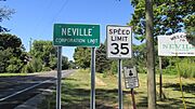
This sign shows the official boundary of Neville village.
-
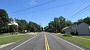
A view looking east on US Highway 52 in Neville.


See also
 In Spanish: Neville (Ohio) para niños
