New Burnside, Illinois facts for kids
Quick facts for kids
New Burnside, Illinois
|
|
|---|---|

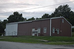
Village Hall
|
|

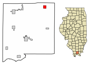
Location of New Burnside in Johnson County, Illinois
|
|

Location of Illinois in the United States
|
|
| Country | United States |
| State | Illinois |
| County | Johnson |
| Area | |
| • Total | 1.05 sq mi (2.73 km2) |
| • Land | 1.04 sq mi (2.71 km2) |
| • Water | 0.01 sq mi (0.02 km2) |
| Elevation | 545 ft (166 m) |
| Population
(2020)
|
|
| • Total | 153 |
| • Density | 146.41/sq mi (56.55/km2) |
| Time zone | UTC-6 (CST) |
| • Summer (DST) | UTC-5 (CDT) |
| ZIP code |
62967
|
| Area code(s) | 618 |
| FIPS code | 17-52285 |
| GNIS feature ID | 2399459 |
| Wikimedia Commons | New Burnside, Illinois |
New Burnside is a small village located in Johnson County, Illinois, in the United States. In 2020, about 153 people lived there.
The Story of New Burnside
New Burnside was started in 1872. It grew quickly because of the Cairo and Vincennes Railroad that ran through it. At its busiest in 1878, about 1,200 people lived here.
The village was first known for its coal mining, much like nearby towns Harrisburg and Carrier Mills. But by 1900, the main business changed to growing fruit in orchards.
When the railroad stopped running, the number of people living in New Burnside slowly went down. Today, the old railroad path is now the Tunnel Hill State Trail, a popular path for bicycles. The village was named after Ambrose Burnside, a general from the American Civil War.
Where is New Burnside?
New Burnside is in the northeastern part of Johnson County, Illinois. You can find it at these coordinates: 37.579166 degrees North and 88.771983 degrees West.
U.S. Route 45 goes through the east side of the village. This road can take you about 18 miles (29 km) northeast to Harrisburg. It also goes about 15 miles (24 km) southwest to Vienna, which is the main town of Johnson County.
Illinois Route 166 starts in New Burnside and goes through the northern part of the village. If you take Routes 166 and 13, you can reach Marion, which is about 19 miles (31 km) to the northwest.
The village covers a total area of about 1.05 square miles (2.73 square kilometers). Most of this area is land, with only a very small part being water. New Burnside is located east of where Interstates 24 and 57 meet.
People of New Burnside
| Historical population | |||
|---|---|---|---|
| Census | Pop. | %± | |
| 1880 | 650 | — | |
| 1890 | 596 | −8.3% | |
| 1900 | 468 | −21.5% | |
| 1910 | 369 | −21.2% | |
| 1920 | 309 | −16.3% | |
| 1930 | 299 | −3.2% | |
| 1940 | 299 | 0.0% | |
| 1950 | 244 | −18.4% | |
| 1960 | 227 | −7.0% | |
| 1970 | 249 | 9.7% | |
| 1980 | 276 | 10.8% | |
| 1990 | 259 | −6.2% | |
| 2000 | 242 | −6.6% | |
| 2010 | 211 | −12.8% | |
| 2020 | 153 | −27.5% | |
| U.S. Decennial Census | |||
In 2000, there were 242 people living in New Burnside. There were 95 households, which are groups of people living together in one home. About 70 of these households were families.
The village had about 229 people per square mile (88 people per square kilometer). This is called the population density.
In 2000, about 31.6% of households had children under 18 living with them. Most households (61.1%) were married couples. About 22.1% of all households were people living alone. About 12.6% of these were people aged 65 or older living by themselves.
The average household had about 2.55 people. The average family had about 2.96 people.
The median age of people in the village was 34 years old. This means half the people were younger than 34, and half were older. About 23.1% of the population was under 18. About 13.6% of the population was 65 or older.
The median income for a household in the village was $31,591. For families, the median income was $32,273.
See also
 In Spanish: New Burnside (Illinois) para niños
 | Mary Eliza Mahoney |
 | Susie King Taylor |
 | Ida Gray |
 | Eliza Ann Grier |

