New Carlisle Historic District facts for kids
Quick facts for kids |
|
|
New Carlisle Historic District
|
|
 |
|
| Location | Roughly bounded by Front, Arch, Chestnut and Bray Sts., New Carlisle, Indiana |
|---|---|
| Area | 24 acres (9.7 ha) |
| Architectural style | Italianate, Italian Villa, Queen Anne |
| NRHP reference No. | 92001653 |
| Added to NRHP | December 14, 1992 |
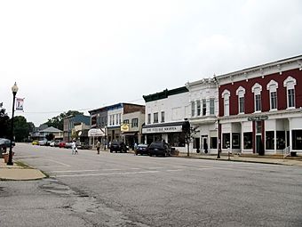
The New Carlisle Historic District is a special area in the town of New Carlisle, Indiana. It is located in northwestern St. Joseph County, Indiana, right next to LaPorte County, Indiana. This district sits on a small hill and looks over a flat, rich area called the Terre Coupee prairie.
The main street, Michigan Street, is very wide (about 45 feet!). Since the town was planned in 1835, it has always been an important road. It was first known as the Michigan Road, then the Lincoln Highway, and now US 20. Two train tracks, one for Conrail and another for the electric South Shore line, run along the northern edge of town at the bottom of the hill. Beyond these tracks, there is still open farmland. This is also true to the west and south of town. However, in recent years, some new shops and homes have been built. This historic district is mainly the commercial heart of New Carlisle, found along Michigan Street.
History of New Carlisle
New Carlisle's location on one of Indiana's main roads helped it grow. In 1851, the Lake Shore Railroad (which later became part of the New York Central Railroad) built its tracks through New Carlisle. These tracks were at the bottom of the hill, running almost parallel to the Michigan Road, which was a few blocks higher up to the south. In the late 1870s, the New York Central system took over the line. It remained part of New York Central until recent years, when it became Conrail.
Trains and Trolleys
After the year 1900, two interurban companies also served New Carlisle. Interurbans were like electric trolleys that connected towns. These companies were the Chicago Lake Shore and South Bend Railway (later the Chicago South Shore and South Bend Railroad) and the Northern Indiana Railway. They ran alongside the New York Central tracks. The Northern Indiana Railway stopped operating during the Great Depression, and its tracks were removed. However, the South Shore line is still running today!
The Rise of Cars
As cars became more popular, they started to challenge the importance of railroads and interurbans. New Carlisle's location on an improved road once again helped it stay successful. The Lincoln Highway was one of the first major roads built across the United States. It was created because people wanted better roads for their cars. This highway crossed northern Indiana through cities like Fort Wayne, South Bend, LaPorte, Valparaiso, and Schererville.
The Lincoln Highway was mostly finished by 1915. It passed through New Carlisle on Michigan Street, which was the old Michigan Road. In 1919, Indiana's new State Highway Commission called the Lincoln Highway a "main market road." This was a step towards setting up Indiana's state highway system. In the 1920s, the United States government started building its own highway network. They named the route running through the top row of counties in northern Indiana, which included parts of the old Michigan Road, as US 20. Many other small towns along this new highway, like Rolling Prairie (about five miles to the west), were bypassed in the 1920s and 1930s. But New Carlisle was not bypassed. This might have been because it would have been too difficult to build a bypass route around the town due to the hills and land features.


