
New Jersey Route 158 facts for kids
Quick facts for kids
|
||||
|---|---|---|---|---|
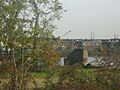
| Centre Street Bridge | ||||
|
Route 158 highlighted in red
|
||||
| Route information | ||||
| Maintained by NJDOT | ||||
| Length | 0.4 mi (0.6 km)
(unofficial)
|
|||
| Existed | 1953–ca. 1979 (demolished) | |||
| Major junctions | ||||
| West end | ||||
| East end | Second Street in Harrison | |||
| Location | ||||
| Counties: | Essex, Hudson | |||
| Highway system | ||||
| New Jersey State Highway Routes Interstate and US
|
||||

Route 158 was a short state highway in Newark and Harrison, New Jersey. It was also known as the Centre Street Bridge. This bridge connected Essex and Hudson counties in New Jersey, United States.
The Centre Street Bridge was first built in 1834. It started as a single-level bridge for trains. Later, in 1911, a second level was added above it for faster train travel. In 1937, the Hudson and Manhattan Railroad (now part of the Port Authority Trans-Hudson line) moved to new tracks. This meant the upper level of the bridge was no longer needed for trains. So, it was changed into a road for cars.
This new road was first called Route 25AD by the New Jersey State Highway Department. It was a special branch of another road, Route 25A. Route 25A later became Route 58 and then part of Interstate 280. On January 1, 1953, Route 25AD was renamed to New Jersey Route 158. Route 158 appeared on state maps until about 1960. After that, it disappeared from maps, and the bridge was taken down around 1979.
Contents
What Was Route 158 Like?
Route 158 started in Newark at the corner of Park Place and Center Street. Center Street is also known as County Route 508. The road went up higher, running next to Park Place. It then crossed over New Jersey Route 21 (the McCarter Highway).
The highway continued east, crossing a small piece of land. Then it went onto the swing bridge itself. Route 158 was a two-lane bridge that crossed into Harrison. Once on land in Harrison, it went north along First Street. Finally, Route 158 turned east onto Essex Street. The road ended at Second Street, which was the end of the highway.
History of the Centre Street Bridge
From Train Bridge to Road Bridge

The lower part of the Centre Street Bridge was built for the New Jersey Railroad. This railroad later became part of the Pennsylvania Railroad. On September 15, 1834, the bridge opened for trains. It only had one level at that time.
In 1901, a train had a small accident on the bridge. Some of its back cars went off the tracks. Luckily, no one was seriously hurt. The cars were then put back on the tracks.
In July 1901, New Jersey and New York wanted to make improvements to the bridge. They asked the United States Congress for money. They wanted to make the Passaic River channel deeper below the bridge.
On April 2, 1911, construction started on a new, faster train line in Newark. This line was for the Hudson and Manhattan Railroad. The plan was to finish it by the end of that summer. This new line would help people travel to New York City.
The bridge was made of steel with concrete. The new upper level was planned to be about 18 feet (5.5 m) high. It would also have a 230 feet (70 m) long section that could swing open. This swinging part was called a drawbridge. The upper level was for the new passenger trains. The lower level was for freight trains.
The new high-speed train line and the two-level Centre Street Bridge were finished on November 18, 1911. The last train track was laid that day. This allowed many trains to run in both directions. The drawbridge was only used by the freight trains on the lower level. On November 25, 1911, the bridge opened again with both levels in use.
.svg)
On June 27, 1937, a new idea came up. The cities and counties wanted to turn the upper level of the bridge into a road. This was because the Hudson and Manhattan Railroad was going to move. It would use tracks next to Route 21. Route 21 had been created in 1927.
The Bridge Becomes a Road

After the trains moved, the Centre Street Bridge's upper level became a state highway. The New Jersey State Highway Department gave it a special name. They had recently named another road, Route 25A. This road was close to the bridge.
A few years later, the upper level of the bridge was named New Jersey State Highway Route 25A-D. This name showed it was a branch of Route 25A. Even though it was a branch, Route 25A-D did not directly connect to Route 25A.
This road stayed the same from Route 21 and Center Street in Newark to Second Street in Harrison. Then, on January 1, 1953, New Jersey changed the names of many state highways. Route 25A-D was renamed Route 158.
Route 158 appeared on maps as a public road until 1960. After that, it was no longer shown on maps. We don't know the exact date Route 158 was officially removed. However, the Centre Street Bridge itself was taken down around 1979.
Where Route 158 Connected
| County | Location | Mile | Roads intersected | Notes | |
|---|---|---|---|---|---|
| Essex | Newark | 0.0 | 0.0 | This was the start of Route 158 in the west. | |
| Hudson | Harrison | 0.4 | 0.64 | Second Street | This was the end of Route 158 in the east. |
| 1.000 mi = 1.609 km; 1.000 km = 0.621 mi | |||||
Images for kids
-
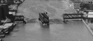
Aerial photo of the Centre Street Bridge around 1974, after the road part was removed
-
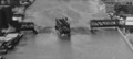
A close-up view of the parts of the Centre Street Bridge that supported it in Newark
-
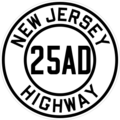
Map showing Route 25AD (1930s-1953)
-
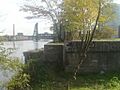
What's left of Route 158 from the Newark side
