Newell Branch (Tidbury Creek tributary) facts for kids
Quick facts for kids Newell Branch |
|
|---|---|
|
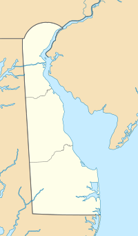
Location of Newell Branch mouth
|
|
| Other name(s) | Tributary to Tidbury Creek |
| Country | United States |
| State | Delaware |
| County | Kent |
| Physical characteristics | |
| Main source | Isaac Branch divide Pond about 0.5 miles west of Star Hill, Delaware 43 ft (13 m) 39°06′03″N 075°33′15″W / 39.10083°N 75.55417°W |
| River mouth | Tidbury Creek Voshell Mill, Delaware 10 ft (3.0 m) 39°05′55″N 075°31′41″W / 39.09861°N 75.52806°W |
| Length | 1.57 mi (2.53 km) |
| Basin features | |
| Progression | generally east |
| River system | St. Jones River |
| Basin size | 1.63 square miles (4.2 km2) |
| Tributaries |
|
| Bridges | Lone Tree Drive, US 13, Peachtree Run, Voshell Mill Road |
Newell Branch is a small stream, about 1.57 miles (2.53 km) long. It flows into Tidbury Creek in Kent County, Delaware. Think of it as a smaller helper stream that adds its water to a bigger one.
Contents
Where Newell Branch Flows
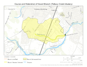
Newell Branch starts in a pond near Star Hill in Kent County, Delaware. This pond is close to another stream called Isaac Branch. From there, Newell Branch flows mostly towards the east. It eventually joins Tidbury Creek in a place called Voshell Mill, Delaware.
Understanding the Watershed
A watershed is like a giant funnel. It's an area of land where all the rain and snowmelt drain into a common stream, river, or lake. The Newell Branch watershed covers about 1.63 square miles (4.22 square kilometers). This means all the water that falls on this area eventually makes its way into Newell Branch.
Rainfall in the Area
The area around Newell Branch gets about 44.8 inches (113.8 cm) of rain and other precipitation each year. This water is important for keeping the stream flowing.
Forest Cover
Only about 1.2% of the Newell Branch watershed is covered by forests. Forests help keep the water clean and prevent soil from washing away.
Maps
 | Shirley Ann Jackson |
 | Garett Morgan |
 | J. Ernest Wilkins Jr. |
 | Elijah McCoy |


