Nicollet Island/East Bank, Minneapolis facts for kids
Quick facts for kids
Nicollet Island/East Bank
|
|
|---|---|
|
Neighborhood
|
|

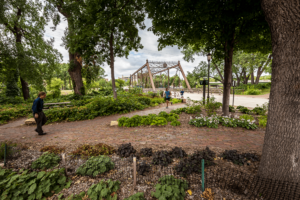
Merriam Street Bridge - showing one of the many areas in the Nicollet Island - East Bank Neighborhood of Minneapolis
|
|
| Nickname(s):
Old Saint Anthony
|
|

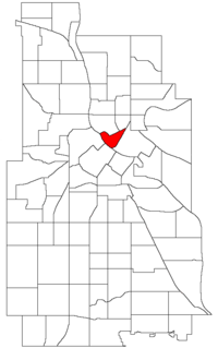
Location of Nicollet Island/East Bank within the U.S. city of Minneapolis
|
|
| Country | United States |
| State | Minnesota |
| County | Hennepin |
| City | Minneapolis |
| Community | University |
| City Council Ward | 3 |
| Area | |
| • Total | 0.247 sq mi (0.64 km2) |
| Population
(2020)
|
|
| • Total | 2,439 |
| • Density | 9,874/sq mi (3,813/km2) |
| Time zone | UTC-6 (CST) |
| • Summer (DST) | UTC-5 (CDT) |
| ZIP code |
55401, 55413, 55414
|
| Area code(s) | 612 |
| Historical population | |||
|---|---|---|---|
| Census | Pop. | %± | |
| 1980 | 203 | — | |
| 1990 | 666 | 228.1% | |
| 2000 | 828 | 24.3% | |
| 2010 | 1,309 | 58.1% | |
| 2020 | 2,439 | 86.3% | |
Nicollet Island/East Bank is a cool neighborhood in Minneapolis, Minnesota. It's part of the University area. This neighborhood sits right across the famous Mississippi River from Downtown Minneapolis, which is the city's main center.
This area includes Nicollet Island itself and the land along the east side of the river. It stretches between Central Avenue and the BNSF train tracks. The "East Bank" part is often called "Old St. Anthony." That's because it used to be the separate town of St. Anthony before it joined Minneapolis in 1872.
Contents
What is Nicollet Island/East Bank?
This neighborhood is unique because it includes both an island and a piece of land on the riverbank. It's one of six neighborhoods that make up the University community in Minneapolis. The neighborhood is bordered by Central Avenue, 2nd Avenue NE, and the Mississippi River.
East Hennepin Avenue runs right through the middle of the neighborhood. This means parts of it are in Northeast Minneapolis, and other parts are in Southeast Minneapolis.
A Look at Its History
The "East Bank" part of this neighborhood has a long history. It was once the independent town of St. Anthony. This town was founded in 1849. It was a very important place in the early days of Minnesota. In 1872, the town of St. Anthony became part of Minneapolis. This is why the area is sometimes called "Old St. Anthony."
Life in the Neighborhood Today
Because Nicollet Island/East Bank is so close to Downtown Minneapolis, it has changed a lot recently. Many new buildings have been built here. You can find new places to shop and modern apartments.
One important place in the neighborhood is DeLaSalle High School. This school is located right on Nicollet Island. It's a private school that has been educating students for many years.
Who Represents the Neighborhood?
The Nicollet Island/East Bank neighborhood is part of Minneapolis City Council Ward 3. A city council member named Michael Rainville helps represent this area. City council members are elected officials. They work to make decisions for the city and help their local neighborhoods.
How Many People Live Here?
The number of people living in Nicollet Island/East Bank has grown a lot over the years. Here's how the population has changed:
- 1980: 203 people
- 1990: 666 people
- 2000: 828 people
- 2010: 1,309 people
- 2020: 2,439 people
This shows that more and more people are choosing to live in this historic and growing neighborhood.
 | John T. Biggers |
 | Thomas Blackshear |
 | Mark Bradford |
 | Beverly Buchanan |

