Central, Minneapolis facts for kids
Quick facts for kids
Central
|
|
|---|---|
|
Community
|
|

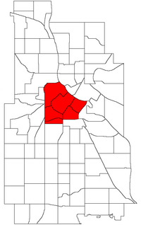
Location of Central Minneapolis in Minneapolis
|
|
| Country | United States |
| State | Minnesota |
| County | Hennepin |
| City | Minneapolis |
| Founded | 1849 |
| City Council Wards | 3, 5, 6, 7 |
| Neighborhoods |
List
|
| Area | |
| • Total | 3.024 sq mi (7.83 km2) |
| Population
(2023)
|
|
| • Total | 58,409 |
| • Density | 19,315/sq mi (7,458/km2) |
| Time zone | UTC-6 (CST) |
| • Summer (DST) | UTC-5 (CDT) |
| ZIP Code |
55401, 55402, 55403, 55404, 55405, 55411, 55415, 55454, 55487
|
| Area code(s) | 612 |
| Historical population | |||
|---|---|---|---|
| Census | Pop. | %± | |
| 1980 | 18,952 | — | |
| 1990 | 21,158 | 11.6% | |
| 2000 | 24,149 | 14.1% | |
| 2010 | 29,725 | 23.1% | |
| 2020 | 53,093 | 78.6% | |
| 2023 (est.) | 58,409 | 96.5% | |

Central is a special area in Minneapolis, Minnesota. It's like a big community made up of six smaller neighborhoods right in the heart of the city. This area includes the busy downtown part where many businesses are. You'll also find old flour mills here, which are historic buildings, and other important industrial spots. Central also has lots of homes and apartments, but it doesn't go across the Mississippi River.
Many important places are located in Central. These include the main offices for big companies like Target and US Bancorp. You can also find the Star Tribune newspaper headquarters and the Hennepin County Government Center, which is where local government works. The Minneapolis Central Library, Minneapolis City Hall, and the TV station WCCO-TV are also in Central.
Central Minneapolis is not controlled by just one City Council member. Instead, it is divided among four different wards. These are Wards 3, 5, 6, and 7. Each ward has its own Council Member who helps make decisions for the city. The current Council Members for these areas are Rainville, Ellison, Osman, and Cashman.
Neighborhoods in Central Minneapolis
Central Minneapolis is made up of six unique neighborhoods. Each one has its own special feel and history.
- Downtown East
- Downtown West
- Elliot Park
- Loring Park
- North Loop, which is also known as the Warehouse District
- Stevens Square/Loring Heights
Images for kids
-
View of downtown Minneapolis from the Stone Arch Bridge.
-
White U.S. Bancorp towers reflected in the Capella Tower.
-
Downtown Minneapolis from Bde Maka Ska.
-
Minneapolis Skyline from Target Field.
-
Wells Fargo Center from the Foshay Tower
-
IDS Center, the tallest building in Minneapolis and Minnesota
-
The Foshay Tower
-
33 South Sixth, also known as the City Center.
-
Target Plaza South, the headquarters of Target Corporation, lit up multicolored during the winter.
-
The CenturyLink Building, the 17th tallest building in Minneapolis.
-
US Bank Plaza, the 6th tallest building in Minneapolis.
 | Calvin Brent |
 | Walter T. Bailey |
 | Martha Cassell Thompson |
 | Alberta Jeannette Cassell |


