Nimmons, Arkansas facts for kids
Quick facts for kids
Nimmons, Arkansas
|
|
|---|---|

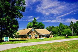
City Hall
|
|

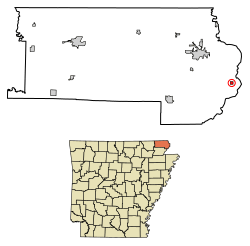
Location of Nimmons in Clay County, Arkansas.
|
|
| Country | United States |
| State | Arkansas |
| County | Clay |
| Area | |
| • Total | 0.25 sq mi (0.65 km2) |
| • Land | 0.25 sq mi (0.65 km2) |
| • Water | 0.00 sq mi (0.00 km2) |
| Elevation | 269 ft (82 m) |
| Population
(2020)
|
|
| • Total | 69 |
| • Density | 276.00/sq mi (106.75/km2) |
| Time zone | UTC-6 (Central (CST)) |
| • Summer (DST) | UTC-5 (CDT) |
| FIPS code | 05-49820 |
| GNIS feature ID | 2406993 |
Nimmons is a small town located in Clay County, Arkansas, in the United States. In 2020, the town had a population of 69 people. This was the same number as in 2010, but it was less than the 100 people who lived there in 2000.
Contents
History of Nimmons
Nimmons started as a stop along a railroad line in 1901. This railroad was called the St. Louis, Kennett and Southeastern Railroad. It later became part of the St. Louis–San Francisco Railway. The town was named after a worker from the railroad.
In 1903, Nimmons got its own post office, which is now closed. For about 20 years, many businesses operated in the town. These businesses were mainly focused on the timber industry, which means they used wood from trees. However, after most of the trees in the area were cut down, the town began to get smaller.
Geography and Location
Nimmons is found in the eastern part of Clay County. It is about 1 mile (1.6 km) west of the St. Francis River. This river forms the border between Arkansas and Missouri. The town covers a total area of about 0.25 square miles (0.65 square kilometers), and all of this area is land.
Natural Surroundings
Nimmons is located in a natural area called the St. Francis Lowlands. This area is part of the larger Mississippi Alluvial Plain. The St. Francis Lowlands are mostly flat. Today, much of this land is used for farming crops.
You can also find special land features here. These include "sand blows" and "sunken lands." These were created by very strong earthquakes that happened in 1811 and 1812. These were known as the 1811–12 New Madrid earthquakes. Many of the natural waterways in this area have been changed by people. They have been "channelized," which means they were made straighter. This has caused some loss of places where water animals and plants live. It also affected the areas along the riverbanks, called "riparian" habitats.
Population Facts
The population of Nimmons has changed over the years. Here is a quick look at how many people lived there:
| Historical population | |||
|---|---|---|---|
| Census | Pop. | %± | |
| 1920 | 297 | — | |
| 1930 | 193 | −35.0% | |
| 1940 | 217 | 12.4% | |
| 1950 | 199 | −8.3% | |
| 1960 | 154 | −22.6% | |
| 1970 | 135 | −12.3% | |
| 1980 | 112 | −17.0% | |
| 1990 | 96 | −14.3% | |
| 2000 | 100 | 4.2% | |
| 2010 | 69 | −31.0% | |
| 2020 | 69 | 0.0% | |
| U.S. Decennial Census | |||
In 2000, there were 100 people living in Nimmons. These people lived in 44 different homes, and 23 of these were families. The town had about 397 people per square mile (154 people per square kilometer). Most of the people living in Nimmons were White. A small number were Native American or Hispanic/Latino.
Households and Families
Out of the 44 homes in 2000, about 20.5% had children under 18 living there. About 43.2% of the homes were married couples living together. Some homes had a female head of household without a husband. About 34.1% of all homes were individuals living alone. Some of these were people aged 65 or older.
The average home had about 2.27 people. The average family had about 3.00 people. The median age of people in the town was 40 years old. This means half the people were younger than 40 and half were older.
Income Information
In 2000, the median income for a household in Nimmons was $28,000 per year. For families, the median income was $29,792. Men generally earned more than women. The average income per person in the town was $10,725. Some families and individuals in Nimmons had lower incomes.
Education
Students in Nimmons attend schools that are part of the Piggott School District.
See also
 In Spanish: Nimmons (Arkansas) para niños
 | Janet Taylor Pickett |
 | Synthia Saint James |
 | Howardena Pindell |
 | Faith Ringgold |

