
Mississippi Alluvial Plain (ecoregion) facts for kids
Quick facts for kids Mississippi Alluvial Plain ecoregion |
|
|---|---|

Level III ecoregions in the region, with the Mississippi Alluvial Plain ecoregion marked as (73) (full map)
|
|
| Ecology | |
| Borders |
List
|
| Geography | |
| Area | 44,834 km2 (17,311 sq mi) |
| Country | United States |
| States | Arkansas, Illinois, Kentucky, Louisiana, Mississippi, Missouri and Tennessee |
| Climate type | Humid subtropical (Cwa) |
The Mississippi Alluvial Plain is a huge natural area, or ecoregion, found in seven U.S. states. It runs alongside the mighty Mississippi River all the way from the Midwestern United States down to the Gulf of Mexico. Most of this ecoregion is in Arkansas, Louisiana, and Mississippi.
This large area has been divided into fifteen smaller sections, called Level IV ecoregions, each with its own special features.
What is the Mississippi Alluvial Plain?
The Mississippi Alluvial Plain stretches along the Mississippi River from where the Ohio River joins it, all the way south to the Gulf of Mexico. This area is a very flat, wide plain made of soil and sediment carried by the river over thousands of years. It's much flatter than the areas around it.
The plain is covered by different types of soil and rock, including loess (wind-blown silt) and deposits left by ancient lakes and glaciers. Even small changes in height, like those from old riverbeds or natural banks, create a bit of variety. The soils here are often clay-like and don't drain water very well, which is typical for this region. Rivers and streams flow very slowly and have soft, fine bottoms.
Home for Wildlife and Birds
This ecoregion is super important for fish and other wildlife. It has the largest connected system of wetlands in North America. Wetlands are like natural sponges that hold water and are home to many different plants and animals.
It's also a major highway for birds! Many birds use this area as a "flyway" (a migration path) when they travel north in spring and south in fall. This path is called the Mississippi Flyway.
The natural plants here are mostly "southern floodplain forests." These are different from the oak and hickory forests found in the higher lands to the west. Sadly, much of this forest and wetland has been cleared for farming. This has caused problems for wildlife and reduced bird populations.
Farming and Water Quality
Today, a lot of the northern and central parts of the plain are used for growing crops like soybeans, cotton, and rice. Farmers also raise fish through aquaculture.
Because of all the farming, water quality can be a problem. Fertilizers, weed killers, bug killers, and animal waste from farms can wash into the rivers and streams. This makes the water cloudy and adds too many nutrients, which can harm aquatic life. Water quality is often worse here than in other parts of Arkansas, especially during spring floods.
Large man-made walls called levees have been built along the Mississippi River to control floods. These levees separate the river from its natural floodplains, which changes how sediment moves and reduces habitats for many species. The land between the levees and the river is called the batture lands. These areas still flood and provide important habitat for "big river" species like the pallid sturgeon.
The region also experiences small earthquakes quite often. The soft soils of the plain can make these earthquake shocks feel stronger.
Special Areas of the Plain
The Mississippi Alluvial Plain is divided into many smaller sections, each with its own unique features. Here are a few examples:
Northern Holocene Meander Belts (73a)

This area is very flat and includes the paths of the Mississippi River from today and long ago. You can see old river bends, natural banks, and oxbow lakes (lakes shaped like a U, formed when a river bend is cut off). The soils here vary from sandy on higher banks to heavy clays in old river channels.
Many wetlands have been drained, and forests cleared for farming. Soybeans, cotton, corn, and rice are common crops. Catfish farms are also growing.
Many important natural areas are protected here, like Choctaw Island Wildlife Management Area in Arkansas and Reelfoot Lake State Park in Tennessee. There are also important historical sites, such as Winterville Mounds in Mississippi.
St. Francis Lowlands (73c)

This ecoregion is flat to uneven and has many old river channels. It's made of sand and gravel left by ancient glaciers. You might even see "sand blows" (areas where sand has been pushed up by earthquakes) and "sunk lands" (areas that dropped down), which were caused by the huge 1811–12 New Madrid earthquakes in the early 1800s.
Most of the original forests have been replaced by farms growing soybeans, corn, and cotton. The St. Francis Sunken Lands Wildlife Management Area in Arkansas protects some of the unique lands near the St. Francis River.
Grand Prairie (73e)
The Grand Prairie is a wide, flat area that used to be covered by tall grass prairie. Now, it's mostly farmland. Before the 1800s, this was Arkansas's largest prairie, a big contrast to the forests elsewhere on the plain.
Today, rice is the main crop here, along with soybeans, cotton, corn, and wheat. The rice fields are important places for many kinds of waterfowl (ducks and geese), making it a popular spot for hunting.
Western Lowlands Holocene Meander Belts (73f)
This ecoregion is a flat floodplain with the paths of the White River, Black River, and Cache River. It has some of the largest remaining areas of natural bottomland hardwood forest in the Mississippi Alluvial Plain.
This area is special because its wetlands, particularly in the Cache-lower White River systems, are recognized internationally as "Wetlands of International Importance" by the Ramsar Convention on Wetlands. This means they are very important for the environment worldwide.
Arkansas/Ouachita River Holocene Meander Belts (73h)

This flat ecoregion includes the paths of the lower Arkansas River and Ouachita Rivers. It has many old river features like oxbow lakes. Bayou Bartholomew flows through a very long section of old river channels here. It's known as one of the most diverse streams in North America, meaning it's home to many different species, including over half of all known mussel species in Louisiana!
Most of the native forest has been cleared for farms and pastures, with corn, cotton, and soybeans being the main crops.
Deltaic Coastal Marshes and Barrier Islands (73o)
This ecoregion is dominated by marshes with salty or brackish water (a mix of fresh and salt water). The plants here, like saltmarsh cordgrass, can handle salty conditions.
These wetlands and marshes are very important because they act as a natural buffer, helping to reduce flooding and storm surges during big storms. However, this area is threatened by a lack of new sediment from the river, erosion, land sinking, and rising sea levels.
Images for kids
-
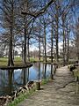
A boardwalk at Reelfoot Lake State Park in Tennessee, showing cypress trees in a wetland area.
-
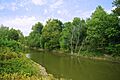
The St. Francis River near the Arkansas-Missouri border.
-
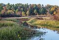
Bayou Bartholomew near Pine Bluff, Arkansas.
