Nobby Islet facts for kids

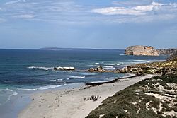
View of Seal Bay looking west with Nobby Islet in background
|
|
| Lua error in Module:Location_map at line 420: attempt to index field 'wikibase' (a nil value). | |
| Geography | |
|---|---|
| Location | Great Australian Bight |
| Administration | |
|
Australia
|
|
Nobby Islet, also known as Knobby Island, is a small island located in the Great Australian Bight. It's off the southern coast of Kangaroo Island in the Australian state of South Australia. This tiny island is about 50 kilometers (31 miles) southwest of Kingscote. Today, Nobby Islet is part of the Seal Bay Conservation Park.
Contents
What is Nobby Islet?
Nobby Islet is about 50 kilometers (31 miles) southwest of Kingscote. It is also about 9.2 kilometers (5.7 miles) east of Point Ellen in Vivonne Bay. The islet is very close to the coast at Seal Bay, only about 200 meters (660 feet) away.
This island is shaped like a cylinder, with sides that go almost straight up. It has a flat top. Nobby Islet stands 75 meters (246 feet) high and covers an area of 12 hectares (30 acres). It is hard to reach because it is in shallow water next to a cliffy coastline. The area also has strong, rolling waves. The cliff faces are crumbly and fragile. In 1996, a survey team used a helicopter to land on the island's top.
How Nobby Islet Formed
Nobby Islet might have formed quite recently, perhaps only 6,000 years ago. This is because the water around it is not very deep. The island is made almost entirely of a type of limestone called Bridgewater Formation calcarenite. This rock is quite crumbly.
In 1996, scientists saw signs of recent rockfalls. Piles of fallen rock were on the island's northern side, which is more sheltered. On the southern side, waves had washed away any fallen rock. The top of the island has gentle terraces made of harder rock. These terraces hold bands of sandy soil. Nobby Islet is technically a sea stack, which is a tall, thin rock column formed by erosion. The water around the islet is about 5.5 meters (18 feet) deep. It hides wave-cut platforms, which are flat areas of rock formed by waves.
Plants and Animals on Nobby Islet
In 1996, the cliff faces of Nobby Islet had very few plants. The top of the island was covered in clumps of Coast tussock-grass. Around the edges, there was a shrubland area. This area was mostly made up of Coast Daisy-bush.
Scientists found 25 other plant species on the island. These included Dry land Tea-tree, Coast beard-heath, Common correa, Cotton bush, Thyme Riceflower, pointed twinleaf, Black-anther Flax Lily, Common Wallaby Grass, and Downy Dodder-laurel.
Only a few types of animals were seen in 1996. An Osprey nest was found on the northern side of the island. White-faced storm petrels were nesting in shallow burrows all over the island's top. Two types of lizards were also found: the marbled gecko and the bull skink.
Protecting Nobby Islet
Nobby Islet has been a protected area for a long time. It first became a fauna reserve in 1964. Then, in 1967, it was declared a fauna conservation reserve. Since 1971, the waters around the island have been part of the Seal Bay Aquatic Reserve. In 1996, Nobby Islet was included in the Seal Bay Conservation Park. As of 2012, the waters around the island are part of a special restricted access zone. This zone is within the Southern Kangaroo Island Marine Park.
 | Ernest Everett Just |
 | Mary Jackson |
 | Emmett Chappelle |
 | Marie Maynard Daly |

