North East River facts for kids
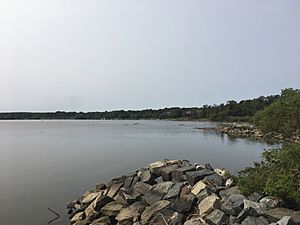
The Northeast River is a cool waterway in Maryland that flows into the famous Chesapeake Bay. It's like a smaller arm of the bay itself! This river is completely "tidal," which means its water level goes up and down with the ocean's tides, even though it's quite far inland.
Contents
What is the Northeast River?
The Northeast River stretches for about 5 miles (8 kilometers). It starts near the town of North East and flows southwest. It passes by another town called Charlestown before joining the main part of the Chesapeake Bay. The river's mouth is between two points of land called Carpenter's Point and Red Point.
Where Does the Water Come From?
The Northeast River gets its water from smaller streams and creeks. The main one is called North East Creek. These creeks gather water from an area that reaches as far north as Nottingham, Pennsylvania.
The River's Location
Even though some of the water comes from Pennsylvania, the entire Northeast River itself is located within Cecil County, Maryland. The land area that drains into the river, called its "watershed," actually extends into Chester County, Pennsylvania. In 1994, the watershed area in Maryland (not counting the water) was about 63 square miles (163 square kilometers). About 6% of this land was covered by things like roads and buildings, which are called "impervious surfaces."
A Little History: Gunter's Harbour
Did you know the Northeast River had a different name long ago? On a map made in 1612 by the famous explorer John Smith, this river was called "Gunter's Harbour." It's interesting how names can change over hundreds of years!
 | May Edward Chinn |
 | Rebecca Cole |
 | Alexa Canady |
 | Dorothy Lavinia Brown |


