
Norton Camp facts for kids
Quick facts for kids Norton Camp |
|
|---|---|

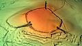
Plan of earthworks at Norton Camp
|
|
| Location | Norton Fitzwarren, Somerset, England |
| Area | 5 hectares (12 acres) |
| Built | Bronze Age |
| Official name: Norton Camp | |
| Reference no. | 189007 |
| Lua error in Module:Location_map at line 420: attempt to index field 'wikibase' (a nil value). | |
Norton Camp is an ancient hill fort located near Taunton in Somerset, England. It was built during the Bronze Age, a very long time ago. Today, you can visit this historic site.
Contents
What is a Hill Fort?
Hill forts are large, walled settlements built on hills. They were common in Britain during the late Bronze Age and early Iron Age, starting around 1000 BC. People built them for different reasons.
Some experts believe they were military sites, built to defend against attacks. Others think they were places where people lived and traded. A popular idea is that they offered protection when communities faced problems, like a growing population needing more land.
Archaeologist Barry Cunliffe suggests that these forts were useful for defense when tensions grew. He believes they weren't always built because of war. Instead, they were strongholds that could be used if fighting broke out.
Exploring Norton Camp
Norton Camp is a large, circular earthwork. It has a single wall, called a rampart, which is up to 3 meters (about 10 feet) high. There are three entrances, which are like sunken paths.
The fort is about 250 meters (820 feet) across. It covers an area of about 5 hectares (12 acres). You can find it at the top of a small hill, about 50 meters (164 feet) high. It's located about 1 kilometer (0.6 miles) north of the River Tone.
A Look into the Past: Norton Camp's History

Archaeologists have studied Norton Camp to learn about its past. In July 1908, Mr. H. St. George Gray led the first excavations. They found that the original ditch around the fort was about 2.75 meters (9 feet) deep. They also found pieces of pottery from the Bronze Age and the Roman period.
More excavations took place between 1968 and 1971. Nancy and Philip Langmaid found even older items. They discovered flint tools from the Mesolithic and Neolithic periods. These are even earlier times than the Bronze Age.
They also found many valuable bronze objects. These included 9 bracelets, an axe-head, and molds for making swords. These items date back to the Bronze Age, around 700 BC. The team also found signs that the fort was made stronger during the Iron Age, before the Romans arrived in Britain around 43 AD.
In 1981, a Neolithic axe-head made from a type of stone called greensand chert was found. Pictures taken from the air also show marks in the ground. These marks suggest there might have been roundhouses inside the fort.
Today, Norton Camp is next to Norton Manor Camp, which is home to the 40 Commando of the Royal Marines.
This ancient site is listed on the Heritage at Risk Register. This means it needs protection because farming activities could damage it. In 2019, the local council and a heritage group bought the site. Now, the entire Norton Camp is open for everyone to visit and explore!
Images for kids
-
3D view of the digital terrain model
