O Vicedo facts for kids
Quick facts for kids
O Vicedo
|
||
|---|---|---|
 |
||
|
||
| Country | Spain | |
| Community | Galicia | |
| Province | Lugo | |
| Comarca | A Mariña Occidental | |
| Area | ||
| • Total | 75.96 km2 (29.33 sq mi) | |
| Elevation | 20 m (70 ft) | |
| Population
(2018)
|
||
| • Total | 1,723 | |
| • Density | 22.683/km2 (58.749/sq mi) | |
| Demonym(s) | Vicedenses | |
| Time zone | UTC+1 (CET) | |
| • Summer (DST) | UTC+2 (CEST) | |
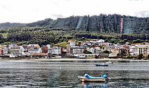
O Vicedo is a small town, also called a municipality, located on the northern coast of Galicia, Spain. It is part of the province of Lugo and belongs to an area known as A Mariña Occidental. It's a beautiful place right by the Cantabrian Sea.
Contents
What's in a Name? The Meaning of O Vicedo
The name O Vicedo comes from an old Latin word, "vitiates". This means "the place where 'vice' grows a lot". A 'vice' is a type of plant, a small pea-like flower, that grows every year. These plants are very common in coastal areas all over Europe.
Exploring O Vicedo's Geography
Where is O Vicedo Located?
O Vicedo is found in the northwest part of the Iberian Peninsula, which is where Spain and Portugal are located. It's in the comarca (a type of region) called A Mariña Occidental, in the northern part of Galicia. To its north is the Cantabrian Sea. To the south, it borders the town of Ourol. To the east, you'll find Viveiro, and to the west, Mañón. The whole area of O Vicedo covers about 75.96 square kilometers.
Mountains and Hills of O Vicedo
The land in O Vicedo is mostly hilly, with some big differences in height. Two main mountain ranges run through the municipality from south to north. One is the Couteiro mountain range. It starts near Ourol and reaches its highest point on Mount Padro, close to the border with Viveiro. The other main area is Riobarba, which has lower mountains. These form a series of smaller hills.
O Vicedo's Beautiful Coastline
Along the coast of O Vicedo, there are eight different beaches. They come in various sizes and are used differently depending on their features and where they are located. Some might be big and popular, while others are smaller and more secluded.
Understanding O Vicedo's Parishes
O Vicedo is made up of several smaller areas called "parishes" (or "parroquias" in Spanish). These are:
- As Negradas
- Cabanas
- Mosende
- San Román do Vale
- Santo Estevo do Vale (O Vicedo)
- Riobarba
- Suegos
Long ago, in the Middle Ages, these parishes belonged to different powerful lords. They were under the control of places like As Negradas and Viveiro.
When Spain created its first municipalities in 1812, the area that is now O Vicedo was split into three separate municipalities: As Negradas, Val, and Cabanas.
Later, in 1835, a new plan for municipal divisions was made. This time, the current area of O Vicedo was divided between two larger councils: Galdo (which included O Vicedo, Negradas, and Vale) and Viveiro (which included Suegos, Mosende, Riobarba, and Cabanas). This arrangement only lasted for five years.
In 1840, the municipality of Riobarba appeared, and its borders were set to include the parishes we know today. Finally, in 1952, the Civil Governor of Lugo decided to move the main town, or capital, of the municipality to O Vicedo itself.
See also
 In Spanish: Vicedo para niños
 | Dorothy Vaughan |
 | Charles Henry Turner |
 | Hildrus Poindexter |
 | Henry Cecil McBay |


