
Oakview, Queensland facts for kids
Quick facts for kids OakviewQueensland |
|||||||||||||||
|---|---|---|---|---|---|---|---|---|---|---|---|---|---|---|---|

Oakview
Location in Queensland
|
|||||||||||||||
| Population | 45 (2021 census) | ||||||||||||||
| • Density | 0.584/km2 (1.51/sq mi) | ||||||||||||||
| Postcode(s) | 4600 | ||||||||||||||
| Area | 77.0 km2 (29.7 sq mi) | ||||||||||||||
| Time zone | AEST (UTC+10:00) | ||||||||||||||
| Location | |||||||||||||||
| LGA(s) | Gympie Region | ||||||||||||||
| State electorate(s) | Nanango | ||||||||||||||
| Federal Division(s) | Wide Bay | ||||||||||||||
|
|||||||||||||||
Oakview is a small rural area, also called a locality, in the Gympie Region of Queensland, Australia. It's a place with a history of mining, but today it's mostly used for grazing animals.
In 2021, only 45 people lived in Oakview.
Contents
Exploring Oakview's Landscape
Oakview has a mix of mountains and flat land. The southern part and the very northern edge are mountainous. In between, there's flatter land that sits about 100 to 150 metres above sea level. This flatter area is where most of the grazing happens.
The northern edge of Oakview is home to Sugarloaf Mountain, which is 340 metres high. This area is mostly untouched nature. The southern mountains reach up to 630 metres and are part of the Oakview State Forest and the Oakview National Park.
A creek called Wide Bay Creek flows through the northern flat parts of Oakview. It winds from west to east and eventually joins the Mary River.
An old railway line used to run through the flat parts of Oakview, but it's not used anymore. There was once a railway station called Oakview railway station. The Wide Bay Highway also crosses through the flatter land, just south of where the railway line used to be.
Amazing Plants and Animals
Oakview National Park is a special place for nature. It has unique bottle trees (Brachychiton) and two types of plants that are almost threatened: the giant ironwood (Choricarpia subargentea) and the Rhodamnia pauciovulata.
This park is also home to some rare animals. You might find the endangered gecko called Phyllurus kabikabi and the Nangur spiny skink (Nangura spinosa). These animals need special protection to survive.
A Look Back at Oakview's History

Oakview has an interesting past. A school called Oakview Provisional School first opened in 1895. It closed and reopened a few times over the years. For a short period, it was a "half-time" school, meaning it shared a teacher with another school. It became Oakview State School in 1918 but closed again in 1928. The school reopened one last time in 1937 and finally closed for good in 1963.
There was also a sawmill in Oakview, run by the Spencer Brothers from 1934 to 1971. It was located close to the old Oakview railway station.
In 2001, a large part of the Oakview State Forest was turned into the Oakview Forest Reserve. This was done to help protect its unique plants and animals. Later, in 2009, some of this reserve became the Oakview National Park. Another part became a Resource Reserve, which allowed for mining exploration. This was because copper had been mined in the area back in the 1860s and 1870s. After the mining exploration was finished, that land was also added to the national park.
Heritage Sites

Oakview has one important historical site listed as a heritage place:
- The Mount Clara smelter, located on Rossmore Road near Fat Hen Creek. This old smelter tells a story about the area's mining past.
Images for kids
-
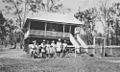
Tennis players standing outside Oakview State School, 1946
-
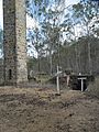
Mount Clara smelter and chimney, 2012
