kids encyclopedia robot

Ocean Gate, New Jersey facts for kids

Kids Encyclopedia Facts
Quick facts for kids
Ocean Gate, New Jersey
Borough
Borough of Ocean Gate
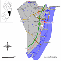
Map of Ocean Gate in Ocean County. Inset: Location of Ocean County highlighted in the State of New Jersey.
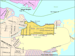
Census Bureau map of Ocean Gate, New Jersey
Country  United States
State  New Jersey
County Ocean
Incorporated February 28, 1918
Government
 • Type Borough
 • Body Borough Council
Area
 • Total 0.54 sq mi (1.41 km2)
 • Land 0.45 sq mi (1.17 km2)
 • Water 0.09 sq mi (0.24 km2)  17.22%
Area rank 544th of 565 in state
33rd of 33 in county
Elevation
7 ft (2 m)
Population
 • Total 2,011
 • Estimate 
(2019)
2,035
 • Rank 485th of 566 in state
22nd of 33 in county
 • Density 4,490.3/sq mi (1,733.7/km2)
 • Density rank 129th of 566 in state
3rd of 33 in county
Time zone UTC−05:00 (Eastern (EST))
 • Summer (DST) UTC−04:00 (Eastern (EDT))
ZIP Code
08740
Area code(s) 732 exchanges: 237, 269, 606
FIPS code 3402954450
GNIS feature ID 885333
Website

Ocean Gate is a borough in Ocean County, New Jersey, United States. As of the 2010 United States Census, the borough's population was 2,011, reflecting a decline of 65 (-3.1%) from the 2,076 counted in the 2000 Census, which had in turn declined by 2 (-0.1%) from the 2,078 counted in the 1990 Census.

History

Trains operated to the area by Pennsylvania Railroad served what was called "Good Luck Point", with visitors building cottages that were the start of the community that became Ocean Gate. AT&T operated a shortwave radio transmitting station after purchasing 175 acres (71 ha) in 1929.

The borough of Ocean Gate was incorporated by an act of the New Jersey Legislature on February 28, 1918, from portions of Berkeley Township. An additional portion of Berkeley Township was annexed on February 28, 1953.

Geography

According to the United States Census Bureau, the borough had a total area of 0.454 square miles (1.175 km2), including 0.448 square miles (1.160 km2) of land and 0.006 square miles (0.015 km2) of water (1.26%).

The borough is bordered by the Ocean County municipality of Berkeley Township.

Demographics

Historical population
Census Pop.
1920 69
1930 174 152.2%
1940 242 39.1%
1950 452 86.8%
1960 706 56.2%
1970 1,081 53.1%
1980 1,385 28.1%
1990 2,078 50.0%
2000 2,076 −0.1%
2010 2,011 −3.1%
2019 (est.) 2,035 1.2%
Population sources:
1920 1920-1930
1930-1990 2000 2010
* = Gained territory in previous decade.

Census 2010

As of the census of 2010, there were 2,011 people, 832 households, and 534 families residing in the borough. The population density was 4,490.3 per square mile (1,733.7/km2). There were 1,203 housing units at an average density of 2,686.1 per square mile (1,037.1/km2)*. The racial makeup of the borough was 95.18% (1,914) White, 1.34% (27) Black or African American, 0.05% (1) Native American, 0.20% (4) Asian, 0.00% (0) Pacific Islander, 2.09% (42) from other races, and 1.14% (23) from two or more races. [[Hispanic (U.S. Census)|Hispanic or Latino of any race were 6.36% (128) of the population.

There were 832 households out of which 27.6% had children under the age of 18 living with them, 40.5% were married couples living together, 17.2% had a female householder with no husband present, and 35.8% were non-families. 28.6% of all households were made up of individuals, and 10.3% had someone living alone who was 65 years of age or older. The average household size was 2.42 and the average family size was 2.98.

In the borough, the population was spread out with 22.2% under the age of 18, 8.3% from 18 to 24, 26.3% from 25 to 44, 29.7% from 45 to 64, and 13.5% who were 65 years of age or older. The median age was 40.1 years. For every 100 females there were 92.6 males. For every 100 females ages 18 and old there were 89.2 males.

The Census Bureau's 2006-2010 American Community Survey showed that (in 2010 inflation-adjusted dollars) median household income was $61,250 (with a margin of error of +/- $9,978) and the median family income was $73,056 (+/- $23,241). Males had a median income of $61,932 (+/- $6,721) versus $43,295 (+/- $6,037) for females. The per capita income for the borough was $29,770 (+/- $4,691). About 2.2% of families and 6.3% of the population were below the poverty line, including 11.3% of those under age 18 and 5.2% of those age 65 or over.

Census 2000

As of the 2000 United States Census there were 2,076 people, 832 households, and 546 families residing in the borough. The population density was 4,749.0 people per square mile (1,821.7/km2). There were 1,152 housing units at an average density of 2,635.3 per square mile (1,010.9/km2). The racial makeup of the borough was 96.53% White, 0.96% African American, 0.14% Native American, 0.96% Asian, 0.53% from other races, and 0.87% from two or more races. Hispanic or Latino of any race were 2.36% of the population.

There were 832 households, out of which 32.6% had children under the age of 18 living with them, 44.0% were married couples living together, 16.2% had a female householder with no husband present, and 34.3% were non-families. 28.1% of all households were made up of individuals, and 11.1% had someone living alone who was 65 years of age or older. The average household size was 2.50 and the average family size was 3.06.

In the borough the population was spread out, with 26.0% under the age of 18, 7.0% from 18 to 24, 32.2% from 25 to 44, 20.3% from 45 to 64, and 14.5% who were 65 years of age or older. The median age was 37 years. For every 100 females, there were 88.9 males. For every 100 females age 18 and over, there were 82.2 males.

The median income for a household in the borough was $41,067, and the median income for a family was $50,847. Males had a median income of $33,558 versus $30,919 for females. The per capita income for the borough was $19,239. About 7.6% of families and 10.3% of the population were below the poverty line, including 12.0% of those under age 18 and 4.3% of those age 65 or over.

Transportation

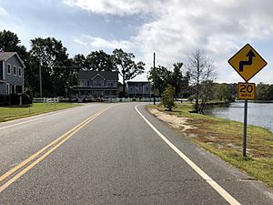
2018-10-04 11 30 16 View south along Ocean County Route 625 (Ocean Gate Drive) just south of Ocean County Route 617 (Chelsea Avenue) in Ocean Gate, Ocean County, New Jersey
County Route 625 (Ocean Gate Drive) southbound in Ocean Gate

As of May 2010, the borough had a total of 12.30 miles (19.79 km) of roadways, of which 2.56 miles (4.12 km) were maintained by the municipality and 9.74 miles (15.68 km) by Ocean County.

No Interstate, U.S. or state highways serve Ocean Gate. The main roads serving the borough are minor county roads, such as County Route 625.

Education

The Ocean Gate School District is a public school district that serves students in pre-kindergarten through sixth grade at Ocean Gate Elementary School. As of the 2018–19 school year, the district, comprised of one school, had an enrollment of 142 students and 15.4 classroom teachers (on an FTE basis), for a student–teacher ratio of 9.2:1. In the 2016–17 school year, Ocean Gate was tied as having the 26th smallest enrollment of any school district in the state, with 149 students.

Public school students in seventh through twelfth grades attend the schools of the Central Regional School District, which serves students from Ocean Gate and from the municipalities of Berkeley Township, Island Heights, Seaside Heights and Seaside Park. Schools in the high school district (with 2018–19 enrollment data from the National Center for Education Statistics) are Central Regional Middle School with 769 students in grades 7–8 and Central Regional High School with 1,483 students in grades 9–12. The high school district's board of education consists of nine members, who are directly elected by the residents of the constituent municipalities to three-year terms of office on a staggered basis, with three seats up for election each year. Ocean Gate is allocated one of the board's nine seats.

Notable people

See also (related category): People from Ocean County, New Jersey

People who were born in, residents of, or otherwise closely associated with Ocean Gate include:

  • Rob Beaton, Guinness World Record holder ("Most Eggs Held in the Hand" - 17, "Most Grains of Rice Eaten with Chopsticks in 3 Minutes" - 78).

See also

Kids robot.svg In Spanish: Ocean Gate para niños

kids search engine
Ocean Gate, New Jersey Facts for Kids. Kiddle Encyclopedia.