Ochelata, Oklahoma facts for kids
Quick facts for kids
Ochelata, Oklahoma
|
|
|---|---|

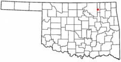
Location of Ochelata, Oklahoma
|
|
| Country | United States |
| State | Oklahoma |
| County | Washington |
| Area | |
| • Total | 0.65 sq mi (1.69 km2) |
| • Land | 0.65 sq mi (1.69 km2) |
| • Water | 0.00 sq mi (0.00 km2) |
| Elevation | 742 ft (226 m) |
| Population
(2020)
|
|
| • Total | 427 |
| • Density | 653.91/sq mi (252.36/km2) |
| Time zone | UTC−6 (Central (CST)) |
| • Summer (DST) | UTC−5 (CDT) |
| ZIP Code |
74051
|
| Area code(s) | 539/918 |
| FIPS code | 40-53700 |
| GNIS feature ID | 2413072 |
Ochelata is a small town located in Washington County, Oklahoma, in the United States. In 2010, about 424 people lived there. By 2020, the population had slightly increased to 427 residents.
Contents
History of Ochelata
This town was started around 1898 by a man named Thomas Ellis. He bought 40 acres of land from Jacob Dick, who was a Cherokee land owner. Ellis first called the community "Otis."
How Ochelata Got Its Name
The town's name was changed in November 1899 to Ochelata. This new name honored Charles Thompson, who was a very important leader of the Cherokee people. His Cherokee name was Oochalata.
Growth and Development
In 1899, the Atchison, Topeka and Santa Fe Railway built tracks that reached Ochelata. This helped the town grow. A post office opened on March 23, 1900. Ochelata officially became a town in 1902.
Ochelata School System
The Ochelata School District joined with other nearby school districts like Ramona, Vera, and Oglesby. Together, they formed the Caney Valley School District. The elementary school for the district is in Ochelata. The main offices, middle school, and high school are located in Ramona. In 2013 and 2014, the old Ochelata School building was fixed up and started being used for classrooms again.
Geography of Ochelata
Ochelata is a small town. According to the United States Census Bureau, the town covers an area of about 0.2 square miles (0.5 square kilometers). All of this area is land, meaning there are no large lakes or rivers within the town limits.
Population and People
| Historical population | |||
|---|---|---|---|
| Census | Pop. | %± | |
| 1910 | 550 | — | |
| 1920 | 419 | −23.8% | |
| 1930 | 335 | −20.0% | |
| 1940 | 333 | −0.6% | |
| 1950 | 357 | 7.2% | |
| 1960 | 312 | −12.6% | |
| 1970 | 330 | 5.8% | |
| 1980 | 480 | 45.5% | |
| 1990 | 441 | −8.1% | |
| 2000 | 494 | 12.0% | |
| 2010 | 424 | −14.2% | |
| 2020 | 427 | 0.7% | |
| U.S. Decennial Census | |||
In 2000, there were 494 people living in Ochelata. These people lived in 175 different homes. Most of these homes (131) were families. The town had about 188 housing units in total.
Who Lives in Ochelata?
In 2000, most of the people in Ochelata (about 72%) were White. About 19% were Native American. A smaller number of people (about 1%) were from other racial backgrounds. About 8% of the people identified with two or more races. Less than 2% of the population was of Hispanic or Latino background.
Families and Age Groups
Out of the 175 homes in 2000, about 36% had children under 18 living there. Most homes (about 61%) were married couples living together. About 10% of homes had a female head of household with no husband present.
The average home in Ochelata had about 2.82 people. The average family had about 3.34 people. The population was spread out by age. About 32% of the people were under 18 years old. About 12% were 65 years or older. The average age in the town was 33 years old.
See also
 In Spanish: Ochelata (Oklahoma) para niños
 | Ernest Everett Just |
 | Mary Jackson |
 | Emmett Chappelle |
 | Marie Maynard Daly |

