Ogygia Island facts for kids

|
|
|
Location of Ogygia Island
|
|
| Geography | |
|---|---|
| Location | Antarctica |
| Coordinates | 62°46′34″S 61°14′15″W / 62.77611°S 61.23750°W |
| Archipelago | South Shetland Islands |
| Area | 2 ha (4.9 acres) |
| Length | 420 m (1,380 ft) |
| Width | 70 m (230 ft) |
| Administration | |
| Administered under the Antarctic Treaty System | |
| Demographics | |
| Population | uninhabited |
Ogygia Island is a small, rocky island located in the South Shetland Islands. It is about 420 meters (1,378 feet) long from west to east and 70 meters (230 feet) wide. This island is separated from Hall Peninsula on Snow Island by a narrow passage, which is about 110 meters (360 feet) wide.
The island has a surface area of 2 hectares (about 5 acres). It is part of the northeast coast of Ivaylo Cove. Long ago, in the early 1800s, people who hunted seals visited this area.
What's in a Name?
Ogygia Island gets its name from a famous place in ancient Greek myths. It is named after the mythical island of Ogygia. In these old stories, Ogygia was the home of a beautiful nymph named Calypso.
Where is Ogygia Island?
Ogygia Island is found in the South Shetland Islands, which are part of Antarctica. Its exact location is 62°46′34″S 61°14′15″W / 62.77611°S 61.23750°W.
Here are some distances to other nearby places:
- It is about 580 meters (1,900 feet) south of Trapecio Island.
- It is 6 kilometers (3.7 miles) south-southwest of the very tip of President Head.
- It is 12.15 kilometers (7.55 miles) northeast of Cape Conway.
- It is 29.8 kilometers (18.5 miles) northwest of Deception Island.
Bulgarian scientists have created maps of this area in 2009 and 2017.
Maps of the Area
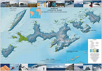
Scientists and explorers use detailed maps to understand places like Ogygia Island. Here are some maps that show Ogygia Island and the surrounding area:
- L. Ivanov. Antarctica: Livingston Island and Greenwich, Robert, Snow and Smith Islands. This is a topographic map at a scale of 1:120000, published in 2010.
- L. Ivanov. Antarctica: Livingston Island and Smith Island. This is another topographic map, at a scale of 1:100000, from 2017.


