Olanta, South Carolina facts for kids
Quick facts for kids
Olanta, South Carolina
|
|
|---|---|
 |
|

Location of Olanta in South Carolina
|
|
| Country | United States |
| State | South Carolina |
| County | Florence |
| Area | |
| • Total | 1.00 sq mi (2.59 km2) |
| • Land | 0.99 sq mi (2.58 km2) |
| • Water | 0.00 sq mi (0.01 km2) |
| Elevation | 112 ft (34 m) |
| Population
(2020)
|
|
| • Total | 550 |
| • Density | 552.76/sq mi (213.47/km2) |
| Time zone | UTC-5 (EST) |
| • Summer (DST) | UTC-4 (EDT) |
| ZIP code |
29114
|
| Area code(s) | 843, 854 |
| FIPS code | 45-52540 |
| GNIS feature ID | 1249947 |
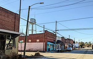
Olanta is a small town in Florence County, South Carolina, United States. It is a part of the larger Florence Metropolitan Statistical Area. In 2020, about 550 people lived there.
Contents
Where is Olanta?
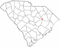
Olanta is located in the southern part of Florence County. You can find its exact spot using these coordinates: 33°56′11″N 79°55′55″W / 33.93639°N 79.93194°W.
Roads and Travel
Several main roads pass through or near Olanta:
- U.S. Route 301 goes through the town. It is known as Jones Road.
- South Carolina Highway 341 heads northwest from Olanta about 13 miles (21 km) to Lynchburg.
- Highway 341 also goes southeast about 13 miles (21 km) to Lake City.
- South Carolina Highway 541 leads east about 12 miles (19 km) to Coward.
Land and Water
The town of Olanta covers a total area of about 1.0 square mile (2.6 square kilometers). A very small part of this area, about 0.004 square miles (0.01 square kilometers), is water.
Who Lives in Olanta?
The number of people living in Olanta has changed over the years. A census is a count of all the people in a place.
| Historical population | |||
|---|---|---|---|
| Census | Pop. | %± | |
| 1910 | 230 | — | |
| 1920 | 409 | 77.8% | |
| 1930 | 433 | 5.9% | |
| 1940 | 515 | 18.9% | |
| 1950 | 586 | 13.8% | |
| 1960 | 568 | −3.1% | |
| 1970 | 640 | 12.7% | |
| 1980 | 699 | 9.2% | |
| 1990 | 687 | −1.7% | |
| 2000 | 613 | −10.8% | |
| 2010 | 563 | −8.2% | |
| 2020 | 550 | −2.3% | |
| U.S. Decennial Census | |||
Population Details (2000 Census)
According to the census taken in 2000, there were 613 people living in Olanta. These people lived in 206 households, and 133 of these were families.
- About 61% of the people were White.
- About 37% were African American.
- A small number of people were from other backgrounds.
Households and Families
- About 28% of households had children under 18 living with them.
- About 41% of households were married couples living together.
- About 20% of households were led by a female without a husband present.
- About 32% of all households were individuals living alone.
- About 14% of households had someone aged 65 or older living alone.
Age and Income
In 2000, the people in Olanta had different ages:
- About 21% were under 18 years old.
- About 21% were 65 years old or older.
The average age of people in Olanta was 41 years.
The median income for a household in the town was $27,813. This means that half of the households earned more than this amount, and half earned less. About 28% of the population lived below the poverty line. This includes about 54% of children under 18.
Education in Olanta
Olanta has a public library. It is a part of the Florence County Library System. This means residents can borrow books and use other library services.
See also
 In Spanish: Olanta para niños
 | Leon Lynch |
 | Milton P. Webster |
 | Ferdinand Smith |

